Welcome to Whitsunday, a Tropical island in the Coral Sea, part of the majestic Pacific Ocean. This guide offers a comprehensive overview of what makes Whitsunday unique – from its geography and climate to its population, infrastructure, and beyond. Dive into the details:
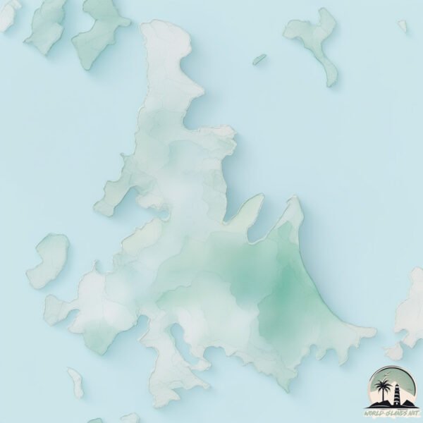
Geography and size of Whitsunday
Size: 106.1 km²
Coastline: 145.5 km
Ocean: Pacific Ocean
Sea: Coral Sea
Continent: Oceania
Whitsunday is a Large Island spanning 106 km² with a coastline of 145 km.
Archipel: Whitsunday Island – A collection of 74 islands off the central coast of Queensland, Australia, known for their stunning natural beauty and as a gateway to the Great Barrier Reef.
Tectonic Plate: Australia – A major tectonic plate covering Australia, New Zealand, and parts of the Indian and Pacific Oceans, known for its relative stability and occasional seismic activity.
The geographic heart of the island is pinpointed at these coordinates:
Latitude: -20.26049086 / Longitude: 148.98185414
Climate and weather of Whitsunday
Climate Zone: Tropical
Climate Details: Tropical Savanna, Wet
Temperature: Hot
Climate Characteristics: Defined by distinct wet and dry seasons with high temperatures year-round. Pronounced rainfall occurs during the wet season, while the dry season is marked by drought.
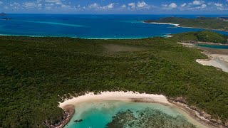
Topography and nature of Whitsunday
Timezone: UTC+10:00
Timezone places: Australia/Sydney
Max. Elevation: 332 m
Mean Elevation: 106 m
Vegetation: Evergreen Broadleaf Forest
Tree Coverage: 92%
The mean elevation is 106 m. The highest elevation on the island reaches approximately 332 meters above sea level. The island is characterized by Hills: Gently sloping landforms with rounded tops, having a maximum elevation between 200 and 500 meters. Hills contribute to a varied landscape on islands.
Dominating Vegetation: Evergreen Broadleaf Forest
Characterized by dense, lush canopies of broadleaf trees that retain their leaves year-round. These forests are typically found in tropical and subtropical regions and are known for their high biodiversity. Whitsunday has a tree cover of 92 %.
Vegetation: 6 vegetation zones – Very Highly Diverse Island
Islands in this range are ecological powerhouses, showcasing a wide array of vegetation zones. Each zone, from lush rainforests to arid scrublands, coastal mangroves to mountainous regions, contributes to a complex and interdependent ecosystem. These islands are often hotspots of biodiversity, supporting numerous species and intricate ecological processes.
Infrastructure and Travelling to Whitsunday
Does the island have a public airport? no.
There is no public and scheduled airport on Whitsunday. The nearest airport is Hamilton Island Airport, located 4 km away.
Does the island have a major port? no.
There are no major ports on Whitsunday. The closest major port is MACKAY, approximately 91 km away.
The mean population of Whitsunday is 1 per km². Whitsunday is Gently Populated. The island belongs to Australia.
Continuing your journey, Hook is the next notable island, situated merely km away.
THE WHITSUNDAYS, AUSTRALIA (2026) | Full Travel Guide To The Whitsunday Islands
Located off the central coast of Queensland, the Whitsundays are an archipelago consisting of 74 pristine islands. They're ...THE WHITSUNDAYS, AUSTRALIA (2026) | Full Travel Guide To The Whitsunday Islands
Located off the central coast of Queensland, the Whitsundays are an ...
Located off the central coast of Queensland, the Whitsundays are an archipelago consisting of 74 pristine islands. They're ...
Whitehaven Beach - Whitsunday Islands in 4K
Whitehaven Beach in stunning 4K. This video has not been colour graded ...
Whitehaven Beach in stunning 4K. This video has not been colour graded at all, everything you see is straight of camera.
We Slept Underwater in Australia 🥹 Whitsundays Islands, Queensland
Welcome to a gem of Queensland, the Whitsunday Islands! In this first ...
Welcome to a gem of Queensland, the Whitsunday Islands! In this first video we're taking you to Hayman Island and the Great ...
WATCH THIS BEFORE YOU GO TO THE WHITSUNDAYS | ULTIMATE WHITSUNDAYS TRAVEL GUIDE
In this video, we're taking you on the Ultimate Whitsunday Islands ...
In this video, we're taking you on the Ultimate Whitsunday Islands adventure! This video covers is an all inclusive travel guide for ...
Explore the Whitsunday Islands: Australia's Tropical Paradise
Discover the Whitsunday Islands, a paradise of pristine beaches, ...
Discover the Whitsunday Islands, a paradise of pristine beaches, crystal-clear waters, and vibrant coral reefs located off the coast ...
Whitsunday Islands Vacation Travel Guide | Expedia
The Whitsundays: An Australian island group nestled in the calm waters ...
The Whitsundays: An Australian island group nestled in the calm waters between the Great Barrier Reef and the Central ...
🇦🇺 WHITSUNDAYS: The ULTIMATE Travel Guide to Australia’s Island Paradise
Welcome to the Whitsundays, Australia — a true paradise on Earth and ...
Welcome to the Whitsundays, Australia — a true paradise on Earth and one of the most breathtaking destinations in the world.
Whitehaven Beach - Whitsunday Islands, Australia 🇦🇺
beach #beautiful #vacation #summer #viral Whitehaven Beach is a ...
beach #beautiful #vacation #summer #viral Whitehaven Beach is a world-renowned beach located on Whitsunday Island in the ...
Top 10 Things to Do in AIRLIE BEACH & the WHITSUNDAYS, Australia in 2026 | Airlie Beach Travel Guide
Support our channel and save on travel by joining our new Top ...
Support our channel and save on travel by joining our new Top Traveller Club: ...
A journey through The Whitsunday Islands
whitsundayislands #thewhitsundays #queensland #greatbarrierreef ...
whitsundayislands #thewhitsundays #queensland #greatbarrierreef #whitehavenbeach #shorts View and book this tour and other ...
The Whitsundays, Queensland Australia
Top 10 Amazing Things to Do in Whitsunday Island, Australia - Travel Video
Top 10 Amazing Things to Do in Whitsunday Island, Australia - Travel ...
Top 10 Amazing Things to Do in Whitsunday Island, Australia - Travel Video The Whitsunday Islands are a breathtaking tropical ...
5 things to do in The Whitsundays
Nestled into northern Queensland, The Whitsundays is a true paradise. ...
Nestled into northern Queensland, The Whitsundays is a true paradise. But it's so much more, with views that'll stun you and ...
AIRLIE BEACH WHITSUNDAYS || The Great Barrier Reef
Airlie Beach Whitsundays Snorkelling Hamilton Island and exploring the ...
Airlie Beach Whitsundays Snorkelling Hamilton Island and exploring the Great Barrier Reef was where we chose to spend our ...
Rough seas Whitsunday Islands #shorts #whitsundays #airliebeach #roughseas
If you want to support us, you can do that right here! Click on the ...
If you want to support us, you can do that right here! Click on the 'THANKS' $ button located just to the right of the 'Thumbs-up' ...
Is HAMILTON ISLAND Worth the Hype? (Surprised by the Whitsundays!)
The Whitsundays have impressed, a lot! It's our second video from this ...
The Whitsundays have impressed, a lot! It's our second video from this Queensland paradise and we've spent 4 days discovering ...
Liveaboard for 10 days exploring the Whitsundays | Ultimate boating & fishing holiday | How & Where
Join us on an epic 10 day adventure as we explore the Whitsunday ...
Join us on an epic 10 day adventure as we explore the Whitsunday Islands while living on board my 7mtr Riptide plate alloy boat.
Airlie Beach and the Whitsunday Islands 🇦🇺 - MUST DO things to see and do when visiting.
Whitsunday island #brisbane #travel #australiadiaries #queensland #northqueenslandcowboys
Discover the Whitsunday Islands – Australia's Tropical Paradise! ✨ ...
Discover the Whitsunday Islands – Australia's Tropical Paradise! ✨ Join me as we explore the stunning Whitsunday Islands, ...
Whitsunday Islands Travel Guide 2025 🌴 | Top Things to Do, Eat & Explore
Welcome to the stunning Whitsunday Islands, Australia! In this travel ...
Welcome to the stunning Whitsunday Islands, Australia! In this travel guide, we'll take you through everything you need to know to ...
Whitsunday Islands ⛰️ #australia #whitehavenbeach #whitsundays #queensland #pvtaustralie
WHY THE WHITSUNDAY ISLANDS ARE SO SPECIAL! - Chance Bay Whitsunday Island
A short video showing what makes this part of the world so special and ...
A short video showing what makes this part of the world so special and such a magnet for cruisers sailing up and down Australia's ...
Touring the Beautiful Whitsundays on a Catamaran
This is the ultimate travel guide to touring the Whitsundays. Skip the ...
This is the ultimate travel guide to touring the Whitsundays. Skip the crowds and find the most pristine, untouched corners of this ...
Whitsunday Islands: Queensland's most beautiful islands 🇦🇺
Cinematic film of Queensland's most beautiful islands.. The ...
Cinematic film of Queensland's most beautiful islands.. The Whitsundays in the Heart of the Great Barrier Reef is located along ...
Magical 2 Days in Airlie Beach 🌴 | Heart Reef🩵 Whitsunday Island Adventure
2 Days in Airlie Beach | Sunset Sail, Heart Reef & Whitehaven Paradise ...
2 Days in Airlie Beach | Sunset Sail, Heart Reef & Whitehaven Paradise Come along with me for a perfect 2-day escape in ...
Australia is classified as Developed region: nonG7: Developed economies outside of the Group of Seven, characterized by high income and advanced economic structures. The level of income is High income: OECD.
News – Latest Updates and Headlines from Whitsunday
Stay informed with the most recent news and important headlines from Whitsunday. Here’s a roundup of the latest developments.
Loading...
Please note: The data used here has been primarily extracted from satellite readings. Deviations from exact values may occur, particularly regarding the height of elevations and population density. Land area and coastline measurements refer to average values at mean high tide.