Yamdena
Welcome to Yamdena, a Tropical island in the Banda Sea, part of the majestic Indian Ocean. This guide offers a comprehensive overview of what makes Yamdena unique – from its geography and climate to its population, infrastructure, and beyond. Dive into the details:
- Geography and Size: Explore the island’s size and location.
- Climate and Weather: Weather patterns and temperature.
- Topography and Nature: Uncover the natural wonders of the island.
- Infrastructure and Travelling: Insights on reaching, staying, and making the most of your visit.
- News and Headlines: Latest News.
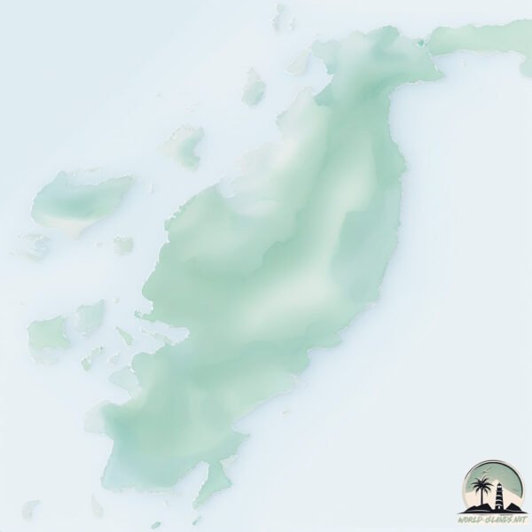
Geography and size of Yamdena
Size: 3283 km²
Coastline: 634 km
Ocean: Indian Ocean
Sea: Banda Sea
Continent: Oceania
Yamdena is a Very Large Island spanning 3283 km² with a coastline of 634 km.
Archipel: Melanesia – A subregion of Oceania in the southwestern Pacific Ocean, including countries like Fiji, Solomon Islands, and Vanuatu, known for their diverse cultures and languages.
Tectonic Plate: Timor – A small tectonic plate in the Timor region, primarily under the Timor Sea. It’s involved in the collision between the Australian and Eurasian plates, contributing to the region’s seismic activity and the uplift of the island of Timor.
The geographic heart of the island is pinpointed at these coordinates:
Latitude: -7.58710456 / Longitude: 131.40728592
Climate and weather of Yamdena
Climate Zone: Tropical
Climate Details: Tropical Savanna, Wet
Temperature: Hot
Climate Characteristics: Defined by distinct wet and dry seasons with high temperatures year-round. Pronounced rainfall occurs during the wet season, while the dry season is marked by drought.
Topography and nature of Yamdena
Timezone: UTC+09:00
Timezone places: Asia/Tokyo
Max. Elevation: 267 m
Mean Elevation: 71 m
Vegetation: Evergreen Broadleaf Forest
Tree Coverage: 68%
The mean elevation is 71 m. The highest elevation on the island reaches approximately 267 meters above sea level. The island is characterized by Hills: Gently sloping landforms with rounded tops, having a maximum elevation between 200 and 500 meters. Hills contribute to a varied landscape on islands.
Dominating Vegetation: Evergreen Broadleaf Forest
Characterized by dense, lush canopies of broadleaf trees that retain their leaves year-round. These forests are typically found in tropical and subtropical regions and are known for their high biodiversity. Yamdena has a tree cover of 68 %.
Vegetation: 15 vegetation zones – Exceptionally Diverse Island
Islands with more than ten vegetation zones are among the most ecologically rich and varied in the world. These islands are akin to miniature continents, boasting an incredible array of ecosystems. The sheer range of habitats, from high peaks to deep valleys, rainforests to deserts, creates a mosaic of life that is unparalleled. They are crucial for conservation and ecological studies.
Infrastructure and Travelling to Yamdena
Does the island have a public airport? yes.
Yamdena has a public and scheduled airport. The following airports are located on this island: Mathilda Batlayeri Airport.
Does the island have a major port? yes.
Yamdena is home to a major port. The following ports are situated on the island: SAUMLAKI.
The mean population of Yamdena is 27 per km². Yamdena is Gently Populated. The island belongs to Indonesia.
Continuing your journey, Pulau Mitak is the next notable island, situated merely km away.
Yamdena island. Beautiful people, intricate wood carvings


Indonesia is classified as Emerging region: MIKT: Mexico, Indonesia, South Korea, and Turkey – Economies recognized for their development potential and emerging market status. The level of income is Lower middle income.
News – Latest Updates and Headlines from Yamdena
Stay informed with the most recent news and important headlines from Yamdena. Here’s a roundup of the latest developments.
- JGC Awarded FEED Contract by INPEX Masela for Onshore LNG Plant and Offshore Production Facility in Indonesia - Euro-petrole.comon 27 August 2025
JGC Awarded FEED Contract by INPEX Masela for Onshore LNG Plant and Offshore Production Facility in Indonesia Euro-petrole.com
- Tanimbar Islands, Location, Vegetation, Latest News - Vajiram & Ravion 17 July 2025
Tanimbar Islands, Location, Vegetation, Latest News Vajiram & Ravi
- Japan's Inpex weighs Indonesia hiring spree for $20bn LNG project - Nikkei Asiaon 9 July 2025
Japan's Inpex weighs Indonesia hiring spree for $20bn LNG project Nikkei Asia
- Inpex targets FID completion for Abadi Field project by 2027 - Indonesia Business Poston 14 February 2025
Inpex targets FID completion for Abadi Field project by 2027 Indonesia Business Post
- Regulator, user, contractor discuss Abadi LNG Project development in Masela Block - Indonesia Business Poston 1 November 2024
Regulator, user, contractor discuss Abadi LNG Project development in Masela Block Indonesia Business Post
- Masela Block Waiting for Settlement of Land Claims and Amdal - Kompas.idon 28 June 2024
Masela Block Waiting for Settlement of Land Claims and Amdal Kompas.id
- Southwest Maluku Doesn't Want to Be a Spectator in the Masela Block - Kompas.idon 21 November 2023
Southwest Maluku Doesn't Want to Be a Spectator in the Masela Block Kompas.id
- No tsunami detected after 7.6 quake strikes eastern Indonesia - The Straits Timeson 10 January 2023
No tsunami detected after 7.6 quake strikes eastern Indonesia The Straits Times
- M5.9 earthquake hits near the coast of Yamdena island, Indonesia - The Watchers - Watching the world evolve and transformon 26 February 2020
M5.9 earthquake hits near the coast of Yamdena island, Indonesia The Watchers - Watching the world evolve and transform
- 8 great reasons to visit the forgotten Maluku Islands - The Jakarta Poston 30 September 2019
8 great reasons to visit the forgotten Maluku Islands The Jakarta Post
Social Media Posts about Yamdena
Please note: The data used here has been primarily extracted from satellite readings. Deviations from exact values may occur, particularly regarding the height of elevations and population density. Land area and coastline measurements refer to average values at mean high tide.