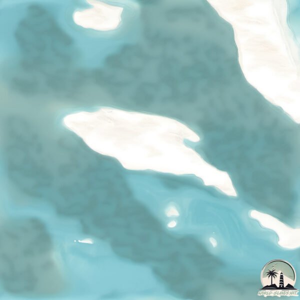
Welcome to Zulaf, a Dry island in the Red Sea, part of the majestic Indian Ocean. This guide offers a comprehensive overview of what makes Zulaf unique – from its geography and climate to its population, infrastructure, and beyond. Dive into the details:
Geography and size of Zulaf
Size: 33.1 km²
Coastline: 34.6 km
Ocean: Indian Ocean
Sea: Red Sea
Continent: Asia
Zulaf is a Medium Island spanning 33 km² with a coastline of 35 km.
Archipel: –
Tectonic Plate: Arabia – A major tectonic plate covering the Arabian Peninsula and parts of the Middle East. The plate is primarily continental and known for its collision with the Eurasian Plate, leading to the uplift of the Zagros Mountains.
The geographic heart of the island is pinpointed at these coordinates:
Latitude: 16.71277906 / Longitude: 41.773993
Climate and weather of Zulaf
Climate Zone: Dry
Climate Details: Hot Deserts Climate
Temperature: Hot
Climate Characteristics: Dominated by extremely hot temperatures, this climate is marked by minimal rainfall and barren landscapes. Nights often experience drastic temperature drops.
Topography and nature of Zulaf
Timezone: UTC+03:00
Timezone places: Asia/Riyadh
Max. Elevation: 41 m
Mean Elevation: 15 m
Vegetation: Sparse Vegetation
Tree Coverage: 3%
The mean elevation is 15 m. The highest elevation on the island reaches approximately 41 meters above sea level. The island is characterized by Plains: Flat, low-lying lands characterized by a maximum elevation of up to 200 meters. On islands, plains are typically coastal lowlands or central flat areas.
Dominating Vegetation: Sparse Vegetation
These regions have limited plant growth, typically due to extreme conditions like aridity or poor soils. Vegetation is scattered and consists of hardy plant species. Zulaf has a tree cover of 3 %.
Vegetation: 3 vegetation zones – Moderately Diverse Island
These islands start to show a broader range of ecological niches. With three vegetation zones, they may offer a mix of ecosystems like coastal areas, inland woods, and perhaps a distinct wetland or dry area. This diversity supports a wider range of flora and fauna, making these islands more ecologically complex than those with minimal diversity.
Infrastructure and Travelling to Zulaf
Does the island have a public airport? no.
There is no public and scheduled airport on Zulaf. The nearest airport is Jizan Regional Airport / King Abdullah bin Abdulaziz Airport, located 87 km away.
Does the island have a major port? no.
There are no major ports on Zulaf. The closest major port is JIZAN, approximately 76 km away.
The mean population of Zulaf is 28 per km². Zulaf is Gently Populated. The island belongs to Saudi Arabia.
Continuing your journey, Sarad Sarso is the next notable island, situated merely km away.
The World's Largest Oil field Saudi Arabia's Ghawarh #shorts
The World's Largest Oil field Saudi Arabia's Ghawarh #shorts
Sajde - Official Music Video | Faheem Abdullah | Huzaif Nazar
Sajde is a song which shows the internal fight of a man with his ...
Sajde is a song which shows the internal fight of a man with his emotions. He has loved beyond capacity and emptied himself.
JEFFREY EPSTEIN'IN ADASINA SIZDIM! (Tapınak ve Yeraltı Tünelleri)
Epstein Adası'nın Karanlık Sırları: Oraya Gittim! Jeffrey Epstein ...
Epstein Adası'nın Karanlık Sırları: Oraya Gittim! Jeffrey Epstein kimdir ve dünyayı sarsan bu karanlık ağ nasıl kuruldu? Bill Clinton ...
Pakistan Idol Episode 5 | Sarfaraz Ali | Tere Bheegay Badan | Karachi Auditions
Sarfaraz Ali mesmerized the stage with his soulful rendition of “Tere ...
Sarfaraz Ali mesmerized the stage with his soulful rendition of “Tere Bheegay Badan” by Mehdi Hassan ✨ Catch his full ...
Parents Sexually Abused Sons They Adopted in ‘House of Horrors’
A judge sentenced two Georgia men to 100 years in prison after they ...
A judge sentenced two Georgia men to 100 years in prison after they adopted two boys and sexually abused them in what ...
Zulu -1964 -Michael Caine -Full Movie
Zulu -1964 -Michael Caine -Full Movie.
Zulu -1964 -Michael Caine -Full Movie.
Reise an die Algarve (Portugal) vom 29.09. - 03.10.2021: Video 2 von Natalie
Hidden Murder Island (2023) movie explained in Hindi | True Thriller and Suspense story explained
Plot- When two young women are attacked while camping, only one makes ...
Plot- When two young women are attacked while camping, only one makes it out alive. Now, back at her parents' island estate ...
Bastion - Saving Zulf
Probably the most powerful moment in the game. I couldn't leave that ...
Probably the most powerful moment in the game. I couldn't leave that adorable fool.
Boomt Venezuela bald wieder? Comeback deutscher Touristen auf Isla Margarita
Nach 15 Jahren sind europäische Kreuzfahrt-Touristinnen und -touristen ...
Nach 15 Jahren sind europäische Kreuzfahrt-Touristinnen und -touristen wieder auf der Insel Margarita an Land gegangen, die ...
The Dark Secret of Epstein Files | Is Donald Trump in Trouble?
Jeffrey Epstein's case remains one of the most disturbing and ...
Jeffrey Epstein's case remains one of the most disturbing and mysterious scandals of the 21st century. A wealthy financier with ties ...
Ellie Williams | Deep blue sea
Another sad ellie edit I'm sorry Also this is a shameless plug for my ...
Another sad ellie edit I'm sorry Also this is a shameless plug for my new tik tok account where I posted this edit as well 🙂 Go follow ...
zulf - squid game 2 (Official Music Video, 2022)
Наконец-то вышел мой первый клип, посмотрите пожалуйста поставьте ...
Наконец-то вышел мой первый клип, посмотрите пожалуйста поставьте лайки подпишитесь на канал, я крутой чцувак да ...
قلعه رومی حصار استانبول
یکی از این دیدنی های ترکیه قلعه روملی حصار استانبول است که در تنگه ...
یکی از این دیدنی های ترکیه قلعه روملی حصار استانبول است که در تنگه بسفر ساحل «روملی»در شهر استانبول واقع شدهاست.
Zulf زُلفوں کا اسیر Real island Story #rohailtalk #storiesinhindi #darr
Zulf, زُلفوں کا اسیر, سچی کہانی, Sacchi kahani, Audio horror story, ...
Zulf, زُلفوں کا اسیر, سچی کہانی, Sacchi kahani, Audio horror story, Read and listen story, Audio book horror, Real story , Horror ...
@SlayyPointOfficial Then Vs Now - Punjabi Kompa🔥 || #slayypoint #edit
Island: Jóhannesson erklärt sich zum Sieger bei Präsidentschaftswahlen
Bei den Präsidentschaftswahlen in Island hat sich der unabhängige ...
Bei den Präsidentschaftswahlen in Island hat sich der unabhängige Kandidat Gudni Jóhannesson zum Sieger erklärt.
Panama ke Khubsurat Beach | Isla Mamey | Colon | Siraj Nalla
Panama ke Khubsurat Beach | Isla Mamey | Colon | Siraj Nalla #shorts ...
Panama ke Khubsurat Beach | Isla Mamey | Colon | Siraj Nalla #shorts #sirajnalla #panama #beach #vacation #island Isla ...
Risen Soundtrack - 05. The Island At Night
Risen Soundtrack - 05. The Island At Night by Kai Rosenkranz (2009)
Risen Soundtrack - 05. The Island At Night by Kai Rosenkranz (2009)
SHOCKING Defection: Advance UK Treasurer Quits & Spills The Truth About Rupert Lowe & Ben Habib
SHOCKING Defection Rocks UK Politics: Advance UK Treasurer Edward ...
SHOCKING Defection Rocks UK Politics: Advance UK Treasurer Edward Oakenfull Quits – “I Was Just a Glorified Bookkeeper!
Off Grid Life: Wilderness Island History Revealed — As Told by One of Its First Children S4 Ep2
MY WILD HOLM S4 Ep2* — Season 4 begins with a rough trip back to the ...
MY WILD HOLM S4 Ep2* — Season 4 begins with a rough trip back to the island, a few surprises, and one moment that makes ...
4K Video Ultra HD Unbelievable Beauty
Welcome to the second 4K video (ultra HD) captured this month on a ...
Welcome to the second 4K video (ultra HD) captured this month on a tropical island of Hispanola.
[Bastion] Episode 2: Zulf
Bastion is een actie role-playing-ervaring die de vertelkunst in games ...
Bastion is een actie role-playing-ervaring die de vertelkunst in games opnieuw definieert, met een alerte verteller die reageert op ...
Boshorus River, Istanbul Turkey
Saudi Arabia is classified as Developed region: nonG7: Developed economies outside of the Group of Seven, characterized by high income and advanced economic structures. The level of income is High income: nonOECD.
News – Latest Updates and Headlines from Zulaf
Stay informed with the most recent news and important headlines from Zulaf. Here’s a roundup of the latest developments.
Loading...
Please note: The data used here has been primarily extracted from satellite readings. Deviations from exact values may occur, particularly regarding the height of elevations and population density. Land area and coastline measurements refer to average values at mean high tide.


![[Bastion] Episode 2: Zulf](https://i.ytimg.com/vi/ck-1gnkIa1c/mqdefault.jpg)
