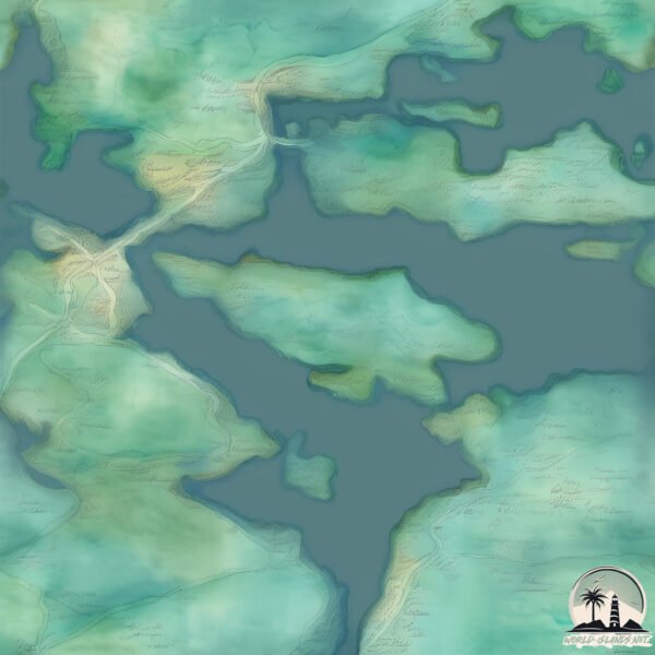
Welcome to Abord, a Continental island in the Gulf of Bothnia, part of the majestic Atlantic Ocean. This guide offers a comprehensive overview of what makes Abord unique – from its geography and climate to its population, infrastructure, and beyond. Dive into the details:
Geography and size of Abord
Size: 8.564 km²
Coastline: 18.4 km
Ocean: Atlantic Ocean
Sea: Gulf of Bothnia
Continent: Europe
Abord is a Small Island spanning 8.6 km² with a coastline of 18.4 km.
Archipel: –
Tectonic Plate: Eurasia – One of the world’s largest tectonic plates, the Eurasian Plate covers a significant portion of Europe and Asia. It’s characterized by diverse geological features, including the Ural Mountains, the European Plain, and the Himalayas formed from its collision with the Indian Plate.
The geographic heart of the island is pinpointed at these coordinates:
Latitude: 62.77444714 / Longitude: 17.98914983
Climate and weather of Abord
Climate Zone: Continental
Climate Details: Warm-Summer Humid Continental Climate
Temperature: Warm Summer
Climate Characteristics: Features warm summers and cold winters with consistent precipitation, common in higher latitudes.
Topography and nature of Abord
Timezone: UTC+01:00
Timezone places: Europe/Paris
Max. Elevation: 110 m
Mean Elevation: 54 m
Vegetation: Mixed Forest
Tree Coverage: 74%
The mean elevation is 54 m. The highest elevation on the island reaches approximately 110 meters above sea level. The island is characterized by Plains: Flat, low-lying lands characterized by a maximum elevation of up to 200 meters. On islands, plains are typically coastal lowlands or central flat areas.
Dominating Vegetation: Mixed Forest
A combination of both deciduous and evergreen trees, often found in transitional zones between forest types. These forests offer a diverse habitat for various wildlife species. Abord has a tree cover of 74 %.
Vegetation: 5 vegetation zones – Highly Diverse Island
With five different vegetation zones, these islands offer a rich tapestry of ecosystems. The variety could include dense forests, open meadows, wetlands, coastal zones, and more. This level of diversity supports an intricate web of life, with each zone playing a vital role in the overall ecological health and balance of the island.
Infrastructure and Travelling to Abord
Does the island have a public airport? no.
There is no public and scheduled airport on Abord. The nearest airport is Kramfors-Sollefteå Höga Kusten Airport, located 35 km away.
Does the island have a major port? no.
There are no major ports on Abord. The closest major port is UTANSJO, approximately 2 km away.
The mean population of Abord is 6 per km². Abord is Gently Populated. The island belongs to Sweden.
Continuing your journey, Hemso is the next notable island, situated merely km away.
An Idiot Abroad - Season 1 (COMPLETE)
disclaimer* I do not claim any ownership of the content in this video. This is An Idiot Abroad Season 1, with all episodes linked ...An Idiot Abroad - Season 1 (COMPLETE)
disclaimer* I do not claim any ownership of the content in this video. ...
disclaimer* I do not claim any ownership of the content in this video. This is An Idiot Abroad Season 1, with all episodes linked ...
BluRay - An Idiot Abroad Season 2 Episode 1 - Desert Island
An Idiot Abroad - Season 2 (COMPLETE)
disclaimer* I do not claim any ownership of the content in this video. ...
disclaimer* I do not claim any ownership of the content in this video. This is An Idiot Abroad Season 2, with all episodes linked ...
What Happened to Harold Davis from Match Me Abroad #matchmeabroad #harolddavis #tlc #realitytv
Jurassic Park in 4K Ultra HD | All Aboard To Jurassic Park Island | Extended Preview
Experience one of the biggest films in motion picture history with ...
Experience one of the biggest films in motion picture history with director Steven Spielberg's ultimate thrill ride, Jurassic Park in 4K ...
Best Bits from S2 E1 DESERT ISLAND An Idiot Abroad
Digging out his passport for the second series, the one and only Karl ...
Digging out his passport for the second series, the one and only Karl Pilkington makes his way through the `Bucket List'. First up ...
Top 5 cheap travel destinations in 2024✈🌴
1⃣Indonesia: Diverse country with stunning landscapes, vibrant ...
1⃣Indonesia: Diverse country with stunning landscapes, vibrant culture, and delicious cuisine. 2⃣Zanzibar: ...
Panic Room on a Yacht?😳🤯 ⬆️Full Tour▶️⬆️#yachts #boats
Swiss Army Knife Boat: RANGER TUG R-43 CB Motor Yacht Tour Cruising ...
Swiss Army Knife Boat: RANGER TUG R-43 CB Motor Yacht Tour Cruising Liveaboard & for the Great Loop.
5 Reasons NOT to buy a live aboard sailing boat - (Watch before you buy!)
After three years of living on a sailing boat full time, we've learned ...
After three years of living on a sailing boat full time, we've learned the hard way about some of the genuine difficulties in living on ...
Ireland Will Pay You $140k to Move There
Republic Of Ireland Is Offering Expats $140000 To Move To There, But ...
Republic Of Ireland Is Offering Expats $140000 To Move To There, But There Is A Catch.
How much it really costs to live on a sailing boat ⛵️ #sailing #shorts
Billionaire’s private island estate 🤯🤩 the end will blow your mind 😜🦩💃🏻 @moskitobvi
Top 10 Vacations Spots You Must Visit in the World! ✈️ Part 1
Best countries for black people to move abroad and leave the U.S.
Need some help getting the F out of the U.S.? Grab my free U.S. ...
Need some help getting the F out of the U.S.? Grab my free U.S. dropout checklist here:
https://bit.ly/3F6pJo0 Follow me on TikTok: ...
Budget friendly alternatives to popular travel destinations
Underwater Bedroom In Maldives
Underwater Bedroom In Maldives #maldives #underwater #muraka #conrad ...
Underwater Bedroom In Maldives #maldives #underwater #muraka #conrad #rangaliisland #resort #hotel #island #travel ...
What I Hate Tourists Doing in Japan
There are so many travelers in Kyoto now as if the covid pandemic ...
There are so many travelers in Kyoto now as if the covid pandemic never happened. As much as I am happy that everyone is ...
High-Pay Jobs Abroad 2026 | USA & Cayman Islands | No Experience Needed
Looking for high-paying jobs abroad in 2026? This video breaks down ...
Looking for high-paying jobs abroad in 2026? This video breaks down **real overseas job opportunities** in the **USA and ...
Top 10 Vacation Spots You Must Visit in the World! ✈️ Part 2
An Idiot Abroad - Jordan [Season 1 Episode 3] HD
Karl is sent to Jordan to investigate the archaeological city of ...
Karl is sent to Jordan to investigate the archaeological city of Petra. Along the way, Ricky and Steve send him to Israel where he ...
Atlantic Crossing DAY 11 ⛵️ ➡️ Caribbean. Real life aboard .. 😴 #sailing #atlanticcrossing
BEST Places To Visit International Under 40k I Cheap Travel Guide 2022 | Budget foreign trip #shorts
A day in The Cayman Islands l Living abroad l expat life #livingabroad #islandlife #smallisland 🌸
The TRUTH About Living on a Sailboat in the Open Ocean ⛵️
Ever wonder what it's like to live at sea? It's a lot different living ...
Ever wonder what it's like to live at sea? It's a lot different living on a sailboat in the open ocean than living on land! Sailing the ...
Aboard a Thai long tail boat in Krabi #travel #thailandtravel #krabi
Sweden is classified as Developed region: nonG7: Developed economies outside of the Group of Seven, characterized by high income and advanced economic structures. The level of income is High income: OECD.
News – Latest Updates and Headlines from Abord
Stay informed with the most recent news and important headlines from Abord. Here’s a roundup of the latest developments.
Loading...
Please note: The data used here has been primarily extracted from satellite readings. Deviations from exact values may occur, particularly regarding the height of elevations and population density. Land area and coastline measurements refer to average values at mean high tide.


![An Idiot Abroad - Jordan [Season 1 Episode 3] HD](https://i.ytimg.com/vi/4_i8zsxnHtM/mqdefault.jpg)


