Adams Island
Welcome to Adams Island, a Polar island in the Baffin Bay, part of the majestic Arctic Ocean. This guide offers a comprehensive overview of what makes Adams Island unique – from its geography and climate to its population, infrastructure, and beyond. Dive into the details:
- Geography and Size: Explore the island’s size and location.
- Climate and Weather: Weather patterns and temperature.
- Topography and Nature: Uncover the natural wonders of the island.
- Infrastructure and Travelling: Insights on reaching, staying, and making the most of your visit.
- News and Headlines: Latest News.
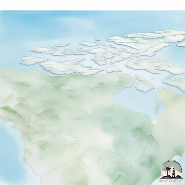
Geography and size of Adams Island
Size: 268.1 km²
Coastline: 158.2 km
Ocean: Arctic Ocean
Sea: Baffin Bay
Continent: North America
Adams Island is a Large Island spanning 268 km² with a coastline of 158 km.
Archipel: Canadian Arctic Archipelago – A vast and remote region in northern Canada, consisting of a series of large and small islands known for their extreme Arctic environment and unique wildlife.
Tectonic Plate: North America – Covers North America and parts of the Atlantic and Arctic Oceans, characterized by diverse geological features and varying levels of seismic activity.
The geographic heart of the island is pinpointed at these coordinates:
Latitude: 71.44451805 / Longitude: -73.1248109
Climate and weather of Adams Island
Climate Zone: Polar
Climate Details: Tundra
Temperature: Cold
Climate Characteristics: The tundra climate features long, extremely cold winters and short, cool summers. Vegetation is limited to mosses, lichens, and small shrubs due to the low temperatures and short growing seasons. Biodiversity is low, but some specialized species thrive.
Topography and nature of Adams Island
Timezone: UTC-05:00
Timezone places: America/New_York
Max. Elevation: 1130 m
Mean Elevation: 449 m
Vegetation: Snow and Ice Covered
Tree Coverage: 48%
The mean elevation is 449 m. The highest elevation on the island reaches approximately 1130 meters above sea level. The island is characterized by Mountains: High, steeply elevated landforms. Characterized by both a high maximum elevation (over 500 meters) and a high mean elevation, creating rugged, mountainous terrains on islands.
Dominating Vegetation: Snow and Ice Covered
These areas are permanently or seasonally covered in snow and ice, with little to no vegetation, such as polar regions and high mountains. Adams Island has a tree cover of 48 %.
Vegetation: 5 vegetation zones – Highly Diverse Island
With five different vegetation zones, these islands offer a rich tapestry of ecosystems. The variety could include dense forests, open meadows, wetlands, coastal zones, and more. This level of diversity supports an intricate web of life, with each zone playing a vital role in the overall ecological health and balance of the island.
Infrastructure and Travelling to Adams Island
Does the island have a public airport? no.
There is no public and scheduled airport on Adams Island. The nearest airport is Prince Rupert Airport, located 173 km away.
Does the island have a major port? no.
There are no major ports on Adams Island. The closest major port is BUTEDALE, approximately 103 km away.
The mean population of Adams Island is 0 per km². Adams Island is Uninhabited. The island belongs to Canada.
The name of the island resonates across different cultures and languages. Here is how it is known around the world: Arabic: بافين; German: Baffininsel; Spanish: Isla de Baffin; French: Île de Baffin; Portuguese: Ilha de Baffin; Russian: Баффинова Земля; Chinese: 巴芬島
Continuing your journey, Estevan is the next notable island, situated merely km away.
Pitcairn Island: The Devastating Price of Paradise

Canada is classified as Developed region: G7: Group of Seven – Major advanced economies, including Canada, France, Germany, Italy, Japan, the United Kingdom, and the United States. The level of income is High income: OECD.
News – Latest Updates and Headlines from Adams Island
Stay informed with the most recent news and important headlines from Adams Island. Here’s a roundup of the latest developments.
Please note: The data used here has been primarily extracted from satellite readings. Deviations from exact values may occur, particularly regarding the height of elevations and population density. Land area and coastline measurements refer to average values at mean high tide.