Welcome to Agnimāri Char, a Tropical island in the Bay of Bengal, part of the majestic Indian Ocean. This guide offers a comprehensive overview of what makes Agnimāri Char unique – from its geography and climate to its population, infrastructure, and beyond. Dive into the details:
Geography and size of Agnimāri Char
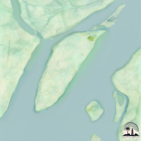
Size: 49.3 km²
Coastline: 33.6 km
Ocean: Indian Ocean
Sea: Bay of Bengal
Continent: Asia
Agnimāri Char is a Medium Island spanning 49 km² with a coastline of 34 km.
Archipel: –
Tectonic Plate: India – A major tectonic plate that initially moved northward at a rapid pace before colliding with the Eurasian Plate. This collision is responsible for the uplift of the Himalayas and the Tibetan Plateau.
The geographic heart of the island is pinpointed at these coordinates:
Latitude: 21.97596205 / Longitude: 88.08856386
Climate and weather of Agnimāri Char
Climate Zone: Tropical
Climate Details: Tropical Savanna, Wet
Temperature: Hot
Climate Characteristics: Defined by distinct wet and dry seasons with high temperatures year-round. Pronounced rainfall occurs during the wet season, while the dry season is marked by drought.
Topography and nature of Agnimāri Char
Timezone: UTC+05:30
Timezone places: Asia/Kolkata
Max. Elevation: 6 m
Mean Elevation: 4 m
Vegetation: Sparse Vegetation
Tree Coverage: 46%
The mean elevation is 4 m. The highest elevation on the island reaches approximately 6 meters above sea level. The island is characterized by Plains: Flat, low-lying lands characterized by a maximum elevation of up to 200 meters. On islands, plains are typically coastal lowlands or central flat areas.
Dominating Vegetation: Sparse Vegetation
These regions have limited plant growth, typically due to extreme conditions like aridity or poor soils. Vegetation is scattered and consists of hardy plant species. Agnimāri Char has a tree cover of 46 %.
Vegetation: 7 vegetation zones – Very Highly Diverse Island
Islands in this range are ecological powerhouses, showcasing a wide array of vegetation zones. Each zone, from lush rainforests to arid scrublands, coastal mangroves to mountainous regions, contributes to a complex and interdependent ecosystem. These islands are often hotspots of biodiversity, supporting numerous species and intricate ecological processes.
Infrastructure and Travelling to Agnimāri Char
Does the island have a public airport? no.
There is no public and scheduled airport on Agnimāri Char. The nearest airport is Netaji Subhash Chandra Bose International Airport, located 78 km away.
Does the island have a major port? no.
There are no major ports on Agnimāri Char. The closest major port is HALDIA PORT, approximately 1 km away.
The mean population of Agnimāri Char is 1209 per km². Agnimāri Char is Densely Populated. The island belongs to India.
Continuing your journey, Sāgar Island is the next notable island, situated merely km away.
Free Health Check Up | Nayachar: An island without any health centre | PKG Initiative
On 5th of January Purono Kolkatar Golpo Society's team visited Nayachar island along with Dr. Sanjay Banerjee for a free health ...Free Health Check Up | Nayachar: An island without any health centre | PKG Initiative
On 5th of January Purono Kolkatar Golpo Society's team visited ...
On 5th of January Purono Kolkatar Golpo Society's team visited Nayachar island along with Dr. Sanjay Banerjee for a free health ...
নয়াচর, লুকিয়ে থাকা এক দ্বীপের সন্ধান I Nayachar, the search for a hidden island!!
নয়াচর, লুকিয়ে থাকা এক দ্বীপের সন্ধান I Nayachar, the search for a ...
নয়াচর, লুকিয়ে থাকা এক দ্বীপের সন্ধান I Nayachar, the search for a hidden island!
নির্জন দ্বীপ নয়াচর ভ্রমণ | Nayachar Island | Haldia | East Midnapore #haldia #haldiavlog
Nayachar Island | Haldia | East Midnapore #haldia #nayacharisland.
Nayachar Island | Haldia | East Midnapore #haldia #nayacharisland.
নয়াচর দ্বীপে কিভাবে মানুষ যাতায়াত করে দেখুন / Naya char ireland
নয়াচর দ্বীপে কিভাবে মানুষ যাতায়াত করে দেখুন/Naya char ireland.
নয়াচর দ্বীপে কিভাবে মানুষ যাতায়াত করে দেখুন/Naya char ireland.
নয়াচর দ্বীপ(Nayachar island west bengal) কীভাবে যাবেন || নয়াচর যাবার আগে ভিডিওটি দেখুন || #naya
হলদিয়ার একদম কাছে,হলদিয়া ও হুগলি নদীর মাঝে গড়ে উঠেছে এই নয়াচর ...
হলদিয়ার একদম কাছে,হলদিয়া ও হুগলি নদীর মাঝে গড়ে উঠেছে এই নয়াচর ...
celebrating late winter cricket at nayachar island
celebrating late winter cricket at nayachar island.
celebrating late winter cricket at nayachar island.
নয়াচর পূর্ব মেদনাপুর naya dip purba Medinipur #duet #review #trending #love #meditation
#naya char #island #haldia #onedaytrip #offbeat #boat #fishing #picnic
Nayachar is an island in the Hooghly River, off Haldia in Purba ...
Nayachar is an island in the Hooghly River, off Haldia in Purba Medinipur in the Indian state of West Bengal. The island is ...
on the way of Nayachar island
Exploring Nayachar: The Secret Island Near Mayapur & Nabadwip
Many explore Mayapur and Nabadwip, but few discover the hidden gem ...
Many explore Mayapur and Nabadwip, but few discover the hidden gem beside the Ganga — Nayachar. This peaceful island is ...
Shadow bowling- having funtime
Nayachar Island trip,When we get trapped in loop of childhood habit ...
Nayachar Island trip,When we get trapped in loop of childhood habit Shadow bowling- Copyright Disclaimer: Under Section 107 ...
ফিরে দেখা নয়াচর দ্বীপ | Nayachar Island | Nayachar tour 2020 | Haldia |
nayachar #purbamedinipur #travellerinsideme This video is about my ...
nayachar #purbamedinipur #travellerinsideme This video is about my visit to a No Man's Island in Purba Medinipur District in West ...
Nayachar island West Bengal || Nayachar island কীভাবে যাবেন || নয়াচর যাবার আগে ভিডিওটি দেখুন ||
Nayachar is an island in the Hooghly River, off Haldia in Purba ...
Nayachar is an island in the Hooghly River, off Haldia in Purba Medinipur in the Indian state of West Bengal. The island inhabited ...
mobile time lapse/wild Nayachar@reactiontime @LikeNastyaofficial
Hailing from the Nadia district near Burdwan, Ganesh Chowdhary's ...
Hailing from the Nadia district near Burdwan, Ganesh Chowdhary's primary education started in the village of Nayachar, lips,time ...
Nayachar island : A new home for organisms|| Things every Indian should know ||General awareness.
In this video we will learn about the new island Nayachar.
In this video we will learn about the new island Nayachar.
Nayachar - Paradise for Bird Watchers and Nature Lovers | Dolphin in Ganga | Day Outing in Winter
Nayachar, a beautiful village of Bengal, is a Paradise for Bird ...
Nayachar, a beautiful village of Bengal, is a Paradise for Bird Watchers and Nature Lovers. The main attraction of this trip however ...
নয়াচর ইকো ভিলেজ হোমস্টে অফবিট ডেস্টিনেশন
নয়াচর দ্বীপ ll Nayachar Island near Haldia
Nayachar is an island in the Hooghly River, near of Haldia in Purba ...
Nayachar is an island in the Hooghly River, near of Haldia in Purba Medinipur in the Indian state of West Bengal. The island ...
Nayachar-র ভাটায় মাছ চাষীরা, বাধ্য হয়ে জেলাশাসকের কাছে স্বেচ্ছামৃত্যুর আবেদন মৎস্যজীবীদের
Nayachar-এর মাছ ব্যবসায়ীদের দুঃখের দিন, কিছুতেই যেন লাভের মুখ দেখছেন ...
Nayachar-এর মাছ ব্যবসায়ীদের দুঃখের দিন, কিছুতেই যেন লাভের মুখ দেখছেন ...
নয়াচর মানেই, নেই রাজ্যের বাসিন্দা, চারিদিকে কেবল হতাশা
নয়াচর মানেই, নেই রাজ্যের বাসিন্দা, চারিদিকে কেবল হতাশা #NewsAmarBangla ...
নয়াচর মানেই, নেই রাজ্যের বাসিন্দা, চারিদিকে কেবল হতাশা #NewsAmarBangla ...
A small, inceptive, river island. Hooghly, West Bengal.
wildlife photography tour at Nayachar Eco village #animals #bbcwildlife #wildlifephotography
wildlife photography tour at Nayachar Eco village #animals ...
wildlife photography tour at Nayachar Eco village #animals #bbcwildlife #wildlifephotography contact number 9641384729.
Nayachar# kata#chalan#2025
কলকাতার খুব কাছেই বেড়ানোর Offbeat destination : নয়াচর
Music Courtesy Music: Building A Treehouse Musician: As Tall As Pine ...
Music Courtesy Music: Building A Treehouse Musician: As Tall As Pine (from Audiio)
India is classified as Emerging region: BRIC: Brazil, Russia, India, and China – Economies noted for their rapid growth and increasing influence on global affairs. The level of income is Lower middle income.
News – Latest Updates and Headlines from Agnimāri Char
Stay informed with the most recent news and important headlines from Agnimāri Char. Here’s a roundup of the latest developments.
Loading...
Please note: The data used here has been primarily extracted from satellite readings. Deviations from exact values may occur, particularly regarding the height of elevations and population density. Land area and coastline measurements refer to average values at mean high tide.