Al Mubarraz
Welcome to Al Mubarraz, a Dry island in the Persian Gulf, part of the majestic Indian Ocean. This guide offers a comprehensive overview of what makes Al Mubarraz unique – from its geography and climate to its population, infrastructure, and beyond. Dive into the details:
- Geography and Size: Explore the island’s size and location.
- Climate and Weather: Weather patterns and temperature.
- Topography and Nature: Uncover the natural wonders of the island.
- Infrastructure and Travelling: Insights on reaching, staying, and making the most of your visit.
- News and Headlines: Latest News.
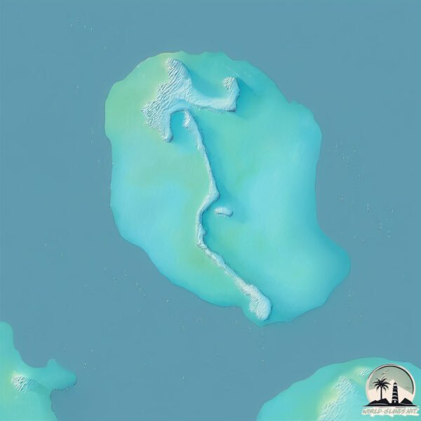
Geography and size of Al Mubarraz
Size: 4.318 km²
Coastline: 52.5 km
Ocean: Indian Ocean
Sea: Persian Gulf
Continent: Asia
Al Mubarraz is a Small Island spanning 4.3 km² with a coastline of 52.5 km.
Archipel: –
Tectonic Plate: Arabia – A major tectonic plate covering the Arabian Peninsula and parts of the Middle East. The plate is primarily continental and known for its collision with the Eurasian Plate, leading to the uplift of the Zagros Mountains.
The geographic heart of the island is pinpointed at these coordinates:
Latitude: 24.52934648 / Longitude: 53.33908368
Climate and weather of Al Mubarraz
Climate Zone: Dry
Climate Details: Hot Deserts Climate
Temperature: Hot
Climate Characteristics: Dominated by extremely hot temperatures, this climate is marked by minimal rainfall and barren landscapes. Nights often experience drastic temperature drops.
Topography and nature of Al Mubarraz
Timezone: UTC+04:00
Timezone places: Asia/Dubai
Max. Elevation: 0 m
Mean Elevation: -1 m
Vegetation: Sparse Vegetation
Tree Coverage: 25%
The mean elevation is -1 m. The highest elevation on the island reaches approximately 0 meters above sea level. The island is characterized by Plains: Flat, low-lying lands characterized by a maximum elevation of up to 200 meters. On islands, plains are typically coastal lowlands or central flat areas.
Dominating Vegetation: Sparse Vegetation
These regions have limited plant growth, typically due to extreme conditions like aridity or poor soils. Vegetation is scattered and consists of hardy plant species. Al Mubarraz has a tree cover of 25 %.
Vegetation: 1 vegetation zones – Minimal Diversity Island
These islands exhibit the most basic level of ecological diversity, often characterized by a single dominant vegetation type. This could be due to extreme environmental conditions, limited land area, or significant human impact. They represent unique ecosystems where specific species have adapted to thrive in these singular environments.
Infrastructure and Travelling to Al Mubarraz
Does the island have a public airport? no.
There is no public and scheduled airport on Al Mubarraz. The nearest airport is Delma Airport, located 108 km away.
Does the island have a major port? no.
There are no major ports on Al Mubarraz. The closest major port is MUBARRAZ OIL TERMINAL, approximately 16 km away.
The mean population of Al Mubarraz is 37 per km². Al Mubarraz is Gently Populated. The island belongs to United Arab Emirates.
Continuing your journey, Jazīrat Marawwaḩ is the next notable island, situated merely km away.
United Arab Emirates is classified as Developing region: Regions characterized by lower income levels, with economies in the process of industrialization and modernization. The level of income is High income: nonOECD.
News – Latest Updates and Headlines from Al Mubarraz
Stay informed with the most recent news and important headlines from Al Mubarraz. Here’s a roundup of the latest developments.
- Middle East contractor wins major offshore prize - Upstream Onlineby "Al Mubarraz island" - Google News on 15 July 2025
Middle East contractor wins major offshore prize Upstream Online
- Rejlers wins engineering contract for Mubarraz oil field project - MEEDby "Al Mubarraz island" - Google News on 2 June 2025
Rejlers wins engineering contract for Mubarraz oil field project MEED
- Hail Field, Abu Dhabi - Offshore Technologyby "Al Mubarraz island" - Google News on 14 August 2024
Hail Field, Abu Dhabi Offshore Technology
- Japan's Cosmo Awarded Offshore Exploration Concession in Abu Dhabi - Offshore Engineer Magazineby "Al Mubarraz island" - Google News on 10 February 2021
Japan's Cosmo Awarded Offshore Exploration Concession in Abu Dhabi Offshore Engineer Magazine
- ADNOC L&S wins 25-year deal to service petroleum ports in Abu Dhabi - Offshore Energyby "Al Mubarraz island" - Google News on 29 September 2020
ADNOC L&S wins 25-year deal to service petroleum ports in Abu Dhabi Offshore Energy
- ADNOC Logistics and Services secures 25-year service contract - Splash247by "Al Mubarraz island" - Google News on 29 September 2020
ADNOC Logistics and Services secures 25-year service contract Splash247
- ADNOC L&S Signs Agreement to Service Petroleum Ports - Egypt Oil & Gasby "Al Mubarraz island" - Google News on 28 September 2020
ADNOC L&S Signs Agreement to Service Petroleum Ports Egypt Oil & Gas
- KBR Lands 'Major' PMC Contract for Ghasha mega-project - Offshore Engineer Magazineby "Al Mubarraz island" - Google News on 3 February 2020
KBR Lands 'Major' PMC Contract for Ghasha mega-project Offshore Engineer Magazine
Please note: The data used here has been primarily extracted from satellite readings. Deviations from exact values may occur, particularly regarding the height of elevations and population density. Land area and coastline measurements refer to average values at mean high tide.