Alatsonísi
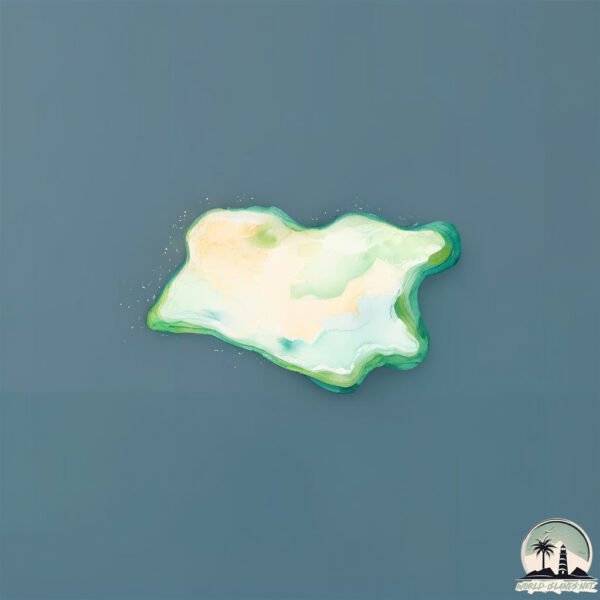
Welcome to Alatsonísi, a Temperate island in the Aegean Sea, part of the majestic Atlantic Ocean. This guide offers a comprehensive overview of what makes Alatsonísi unique – from its geography and climate to its population, infrastructure, and beyond. Dive into the details:
- Geography and Size: Explore the island’s size and location.
- Climate and Weather: Weather patterns and temperature.
- Topography and Nature: Uncover the natural wonders of the island.
- Infrastructure and Travelling: Insights on reaching, staying, and making the most of your visit.
- News and Headlines: Latest News.
Geography and size of Alatsonísi
Size: 0.298 km²
Coastline: 2.3 km
Ocean: Atlantic Ocean
Sea: Aegean Sea
Continent: Europe
Alatsonísi is a Tiny Island spanning 0.298 km² with a coastline of 2.3 km.
Archipel: –
Tectonic Plate: Aegean Sea – Located in the eastern Mediterranean, this microplate is characterized by seismic and volcanic activity due to its interaction with the Eurasian and African Plates.
The geographic heart of the island is pinpointed at these coordinates:
Latitude: 37.53199464 / Longitude: 26.41634454
Climate and weather of Alatsonísi
Climate Zone: Temperate
Climate Details: Hot-Summer Mediterranean Climate
Temperature: Hot Summer
Climate Characteristics: Characterized by hot, dry summers and mild, wet winters, typical of coastal areas with abundant sunshine.
Topography and nature of Alatsonísi
Timezone: UTC+02:00
Timezone places: Europe/Mariehamn
Max. Elevation: -1 m
Mean Elevation: -9 m
Vegetation: Open Woodland
Tree Coverage: 37%
The mean elevation is -9 m. Remarkably, this unique island barely emerges above the sea level, showcasing nature’s fascinating interplay with the ocean. The island is characterized by Plains: Flat, low-lying lands characterized by a maximum elevation of up to 200 meters. On islands, plains are typically coastal lowlands or central flat areas.
Dominating Vegetation: Open Woodland
Characterized by sparsely distributed trees with open canopy allowing sunlight to penetrate, supporting grasses and shrubs underneath. Often found in drier or transitional environments. Alatsonísi has a tree cover of 37 %.
Vegetation: 2 vegetation zones – Low Diversity Island
Islands with two distinct vegetation zones offer slightly more ecological variety. These zones could be due to differences in elevation, moisture, or other environmental factors. While still limited in biodiversity, these islands may offer a contrast between the two zones, such as a coastline with mangroves and an inland area with grassland.
Infrastructure and Travelling to Alatsonísi
Does the island have a public airport? no.
There is no public and scheduled airport on Alatsonísi. The nearest airport is Ikaria Airport, located 18 km away.
Does the island have a major port? no.
There are no major ports on Alatsonísi. The closest major port is NEON KARLOVAS, approximately 42 km away.
The mean population of Alatsonísi is 29 per km². Alatsonísi is Gently Populated. The island belongs to Greece.
Continuing your journey, Nisí Thýmaina is the next notable island, situated merely km away.
I visited America’s most remote island (Adak, AK)

Greece is classified as Developed region: nonG7: Developed economies outside of the Group of Seven, characterized by high income and advanced economic structures. The level of income is High income: OECD.
News – Latest Updates and Headlines from Alatsonísi
Stay informed with the most recent news and important headlines from Alatsonísi. Here’s a roundup of the latest developments.
Please note: The data used here has been primarily extracted from satellite readings. Deviations from exact values may occur, particularly regarding the height of elevations and population density. Land area and coastline measurements refer to average values at mean high tide.