Welcome to Ambre, a Tropical island in the Indian Ocean, part of the majestic Indian Ocean. This guide offers a comprehensive overview of what makes Ambre unique – from its geography and climate to its population, infrastructure, and beyond. Dive into the details:
Geography and size of Ambre
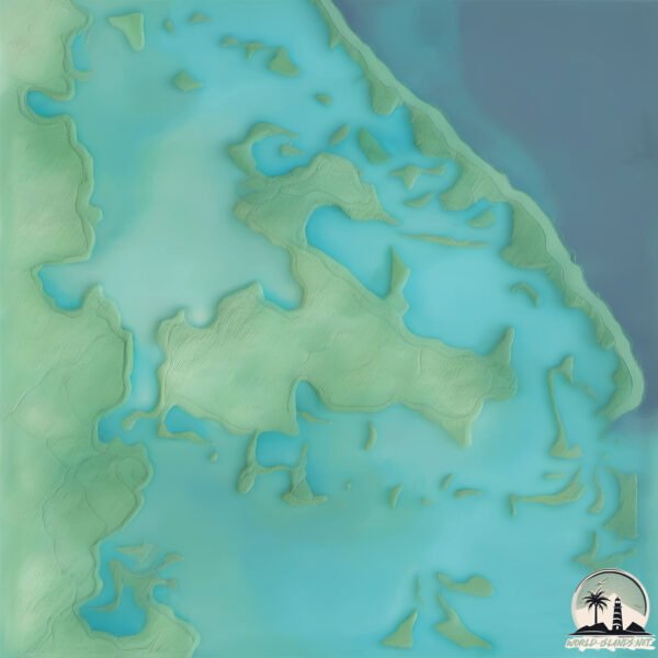
Size: 2.21 km²
Coastline: 11.9 km
Ocean: Indian Ocean
Sea: Indian Ocean
Continent: Seven seas (open ocean)
Ambre is a Small Island spanning 2.2 km² with a coastline of 11.9 km.
Archipel: Mascarene Islands – Located in the Indian Ocean, these islands, including Mauritius and Réunion, are known for their unique wildlife and vibrant cultures.
Tectonic Plate: Somalia – A large tectonic plate covering the Horn of Africa and parts of the Indian Ocean, known for the East African Rift where it’s splitting away from the African Plate.
The geographic heart of the island is pinpointed at these coordinates:
Latitude: -20.03624199 / Longitude: 57.6991501
Climate and weather of Ambre
Climate Zone: Tropical
Climate Details: Tropical Savanna, Wet
Temperature: Hot
Climate Characteristics: Defined by distinct wet and dry seasons with high temperatures year-round. Pronounced rainfall occurs during the wet season, while the dry season is marked by drought.
Topography and nature of Ambre
Timezone: UTC+04:00
Timezone places: Asia/Dubai
Max. Elevation: 2 m
Mean Elevation: -1 m
Vegetation: Evergreen Broadleaf Forest
Tree Coverage: 73%
The mean elevation is -1 m. The highest elevation on the island reaches approximately 2 meters above sea level. The island is characterized by Plains: Flat, low-lying lands characterized by a maximum elevation of up to 200 meters. On islands, plains are typically coastal lowlands or central flat areas.
Dominating Vegetation: Evergreen Broadleaf Forest
Characterized by dense, lush canopies of broadleaf trees that retain their leaves year-round. These forests are typically found in tropical and subtropical regions and are known for their high biodiversity. Ambre has a tree cover of 73 %.
Vegetation: 3 vegetation zones – Moderately Diverse Island
These islands start to show a broader range of ecological niches. With three vegetation zones, they may offer a mix of ecosystems like coastal areas, inland woods, and perhaps a distinct wetland or dry area. This diversity supports a wider range of flora and fauna, making these islands more ecologically complex than those with minimal diversity.
Infrastructure and Travelling to Ambre
Does the island have a public airport? no.
There is no public and scheduled airport on Ambre. The nearest airport is Sir Seewoosagur Ramgoolam International Airport, located 43 km away.
Does the island have a major port? no.
There are no major ports on Ambre. The closest major port is PORT LOUIS, approximately 24 km away.
The mean population of Ambre is 720 per km². Ambre is Densely Populated. The island belongs to Mauritius.
Continuing your journey, Mauritius is the next notable island, situated merely km away.
Amber Island - Full Song Wave 14 (My Singing Monsters)
Amber Island's full song with Viveine and Gnarls! All island songs: ...Amber Island - Full Song Wave 14 (My Singing Monsters)
Amber Island's full song with Viveine and Gnarls! All island songs: ...
Amber Island's full song with Viveine and Gnarls! All island songs: ...
Ile D'Ambre - Mauritius Island
A full hike clip at Ile D'Ambre. Ile D'Ambre is the third national ...
A full hike clip at Ile D'Ambre. Ile D'Ambre is the third national park in Mauritius. It is situated near Poudre D'Or. It used to inhabit ...
Stunning Ambre Resort Mauritius: Is This The Best Adults-Only Beach Getaway? #travel #vacation
Welcome to Ambre Mauritius, a serene adults-only escape on the ...
Welcome to Ambre Mauritius, a serene adults-only escape on the tranquil East Coast of Mauritius! This 4-star all-inclusive ...
Mauritius East Coast, Hotel Ambre, Reef, Sea Turtles & Dolphins
Come & Have A Look At The South East Of Mauritius, We stayed at the ...
Come & Have A Look At The South East Of Mauritius, We stayed at the Hotel Ambre Booked with Tui, it was a beautiful resort all ...
Ile Maurice Poudre d'Or Village - Excursion sur l'île d'Ambre
Journée avec l'association Les Cent Pieds Île de la Réunion.
Journée avec l'association Les Cent Pieds Île de la Réunion.
Ranking Worst Amber Island Monsters | My Singing Monsters
Bain de Rosnay: Sea Kayak Adventures fait visiter l’île d’Ambre à la pagaie
Depuis quatre mois, Sea Kayak Adventures propose une découverte de ...
Depuis quatre mois, Sea Kayak Adventures propose une découverte de l'île d'Ambre, de l'île aux Bernaches et de Trou Coco en ...
Ambre Mauritius | A Sun Resort | Mavic 2 Zoom + Osmo 4K
Have a look how the Ambre Hotel in Mauritius look like. We spend two ...
Have a look how the Ambre Hotel in Mauritius look like. We spend two fantastic weeks in this awesome hotel on the East side of ...
Everything To Know About Amber Island in My Singing Monsters.
Ambre (Adults Only) Resort & Spa, Mauritius | Review
This resort is lucky it's so beautiful, because it's giving Wall-e. ...
This resort is lucky it's so beautiful, because it's giving Wall-e. Let's jump into things I loved and disliked about Ambre Resort and ...
walk round of deluxe sea view room at the Ambre Mauritius
recently stayed at the @Ambre Mauritius in one of there deluxe sea ...
recently stayed at the @Ambre Mauritius in one of there deluxe sea view rooms with balcony, don't go by the pictures on there ...
Ambre Mauritius Serene Adults Only Resort on the East Coast
Ambre Mauritius Serene Adults Only Resort on the East Coast © Sunlife ...
Ambre Mauritius Serene Adults Only Resort on the East Coast © Sunlife Resorts.
Hiking at Ile d'Ambre
Explore the incredible islet Ile d'Ambre, where you will find ...
Explore the incredible islet Ile d'Ambre, where you will find mangroves, Tamarin trees, butterflies, indigenous birds, old ruins and ...
Ambre A Sun Resort, Belle Mare, Mauritius, 4 star hotel
Subscribe for more videos: ...
Kayaking mangroves of Île d'Ambre, Mauritius
Awesome full day sea kayaking and snorkelling trip exploring the ...
Awesome full day sea kayaking and snorkelling trip exploring the mangroves of Île d'Ambre (Amber Island, Mauritius) with ...
Ambre Mauritius Hotel Review: Luxury Adults-Only Resort in Mauritius
Explore Ambre Mauritius, a luxurious adults-only resort on the east ...
Explore Ambre Mauritius, a luxurious adults-only resort on the east coast of Mauritius, offering stunning ocean views, vibrant ...
Ambre Mauritius | Serene Adults-Only Resort on the East Coast
Welcome to Ambre Mauritius, a tranquil adults-only resort on the ...
Welcome to Ambre Mauritius, a tranquil adults-only resort on the serene East Coast of Mauritius! 🏖️ Set along a breathtaking ...
Sea Kayaking at Ile d'Ambre
Slide into your kayak and explore the mangroves, hidden bays and the ...
Slide into your kayak and explore the mangroves, hidden bays and the nature of Ile d'Ambre. During this tour you will get to ...
Trip - At Île d'ambre Mauritius
Went on a trip at ile d'ambre with family a surely refreshing trip got ...
Went on a trip at ile d'ambre with family a surely refreshing trip got time to relax and enjoy the beauty of nature and to gaze at the ...
Ambre Resort in Mauritius
Located on the east coast of Mauritius, Ambre Hotel makes for a ...
Located on the east coast of Mauritius, Ambre Hotel makes for a tranquil delight where island living can be experienced at its best.
Review of Ambre Sun Resort. Belle Mare. Mauritius.
the Ambre resort and spa hotel in Mauritius
this from our 10 night stay at the Ambre resort and spa on the ...
this from our 10 night stay at the Ambre resort and spa on the beautiful island of Mauritius , the hotel is fantastic and the staff cater ...
St Antoine Private Residence - |Il d' Ambre
Ile d' Ambre is an islet off St. Antoine, where residents are free to ...
Ile d' Ambre is an islet off St. Antoine, where residents are free to tour through the mangroves, or fish and snorkel in its ...
Kayaking Mangroves Mauritius - Ile d Ambre Sea Kayaking #mauritius #travel
Explore the serene mangroves of Ile d'Ambre in Mauritius! Paddle ...
Explore the serene mangroves of Ile d'Ambre in Mauritius! Paddle through winding waterways, spot wildlife, and enjoy the ...
Mauritius is classified as Developing region: Regions characterized by lower income levels, with economies in the process of industrialization and modernization. The level of income is Upper middle income.
News – Latest Updates and Headlines from Ambre
Stay informed with the most recent news and important headlines from Ambre. Here’s a roundup of the latest developments.
Loading...
Please note: The data used here has been primarily extracted from satellite readings. Deviations from exact values may occur, particularly regarding the height of elevations and population density. Land area and coastline measurements refer to average values at mean high tide.