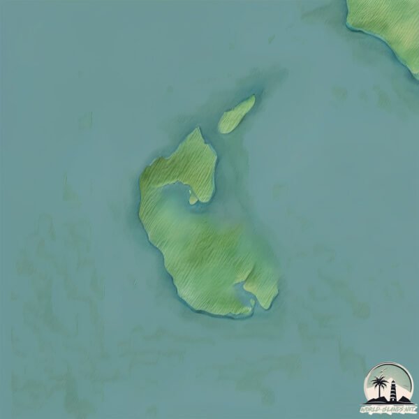
Welcome to Aniktun, a Continental island in the Bering Sea, part of the majestic Pacific Ocean. This guide offers a comprehensive overview of what makes Aniktun unique – from its geography and climate to its population, infrastructure, and beyond. Dive into the details:
Geography and size of Aniktun
Size: 3.027 km²
Coastline: 27.4 km
Ocean: Pacific Ocean
Sea: Bering Sea
Continent: North America
Aniktun is a Small Island spanning 3 km² with a coastline of 27.4 km.
Archipel: –
Tectonic Plate: North America – Covers North America and parts of the Atlantic and Arctic Oceans, characterized by diverse geological features and varying levels of seismic activity.
The geographic heart of the island is pinpointed at these coordinates:
Latitude: 61.75505512 / Longitude: -166.13207091
Climate and weather of Aniktun
Climate Zone: Continental
Climate Details: Subarctic Climate
Temperature: Cold Summer
Climate Characteristics: Characterized by long, extremely cold winters and short, cool summers, often found in northern latitudes of North America and Eurasia.
Topography and nature of Aniktun
Timezone: UTC-09:00
Timezone places: America/Anchorage
Max. Elevation: 11 m
Mean Elevation: 11 m
Vegetation: Herbaceous Cover
Tree Coverage: 94%
The mean elevation is 11 m. The highest elevation on the island reaches approximately 11 meters above sea level. The island is characterized by Plains: Flat, low-lying lands characterized by a maximum elevation of up to 200 meters. On islands, plains are typically coastal lowlands or central flat areas.
Dominating Vegetation: Herbaceous Cover
Comprising mainly of grasses, herbs, and ferns, these areas are common in prairies, meadows, and savannas, and can vary widely in species composition. Aniktun has a tree cover of 94 %.
Vegetation: 3 vegetation zones – Moderately Diverse Island
These islands start to show a broader range of ecological niches. With three vegetation zones, they may offer a mix of ecosystems like coastal areas, inland woods, and perhaps a distinct wetland or dry area. This diversity supports a wider range of flora and fauna, making these islands more ecologically complex than those with minimal diversity.
Infrastructure and Travelling to Aniktun
Does the island have a public airport? no.
There is no public and scheduled airport on Aniktun. The nearest airport is Chevak Airport, located 61 km away.
Does the island have a major port? no.
There are no major ports on Aniktun. The closest major port is NASH HARBOR, approximately 195 km away.
The mean population of Aniktun is 0 per km². Aniktun is Uninhabited. The island belongs to United States of America.
Continuing your journey, Munson is the next notable island, situated merely km away.
Quebec's Anticosti Island named UNESCO World Heritage Site
Anticosti Island, a large island in the Gulf of St. Lawrence, has been named a UNESCO World Heritage Site. The designation adds ...Quebec's Anticosti Island named UNESCO World Heritage Site
Anticosti Island, a large island in the Gulf of St. Lawrence, has been ...
Anticosti Island, a large island in the Gulf of St. Lawrence, has been named a UNESCO World Heritage Site. The designation adds ...
Discovering Anticosti Island: A Fossil Treasure in Canada
Discover the untamed beauty of Anticosti Island, a UNESCO World ...
Discover the untamed beauty of Anticosti Island, a UNESCO World Heritage Site renowned for its rugged coastline, misty forests, ...
Canada's Island of Fossils | Canada's Strangest Island Part 6| Anticosti Island
In this video we explore one of Canada's most fascinating islands, ...
In this video we explore one of Canada's most fascinating islands, known for its unique geology and wildlife to ask the question "Is ...
Girl survives on an island of coconuts #camping #survival #bushcraft #outdoors #coconut #island
Quebec's Anticosti Island named UNESCO heritage site
Genevieve Beauchemin explains why Anticosti Island in Quebec has been ...
Genevieve Beauchemin explains why Anticosti Island in Quebec has been recognized as a UNESCO world heritage site.
🦌 Anticosti Island – Part 1 | November Whitetail Adventure with Born to Hunt & Browning 🌲❄️
n this wild and windswept episode, Eric Lacelle, Eric Marion, and ...
n this wild and windswept episode, Eric Lacelle, Eric Marion, and Miguel travel to the legendary Anticosti Island for a late-season ...
Aneityum and Mystery Islands
Aneityum and Mystery Islands are at the very south of Vanuatu and has ...
Aneityum and Mystery Islands are at the very south of Vanuatu and has some of the clearest and most abundant marine life we ...
Never Visit This Island…
Would you visit the North Sentinel Island? All credit goes to the ...
Would you visit the North Sentinel Island? All credit goes to the original creator: @nelkfilmz Join this channel to get access to ...
An Island
Provided to YouTube by Epic An Island · Chevelle La Gárgola ℗ 2014 ...
Provided to YouTube by Epic An Island · Chevelle La Gárgola ℗ 2014 Epic Records, a division of Sony Music Entertainment ...
What did I just hear island boy song #shorts
uTureShow.
uTureShow.
🦌 Anticosti Island – Part 2 | Snow, Bucks & Brotherhood with Born to Hunt & Browning ❄️🏹
The story continues as Eric L., Eric M., Miguel, and Mark Coté of ...
The story continues as Eric L., Eric M., Miguel, and Mark Coté of Browning Canada push deeper into the snowy wilds of Anticosti ...
SHE SAID SHES FROM THE ISLANDS🌴😎 #robloxedit #shorts #mm2
An Island Of Toenail Clippings? 🤮
Jason Derulo, Frozy & Tomo - From The Islands (Kompa Passion) (Official Music Video)
Lyrics: (JASON) She said she's from the Islands And I'm just tryna ...
Lyrics: (JASON) She said she's from the Islands And I'm just tryna find her girl You are my desire You're all that I require (TOMO) ...
MYSTERY ISLAND 🏝️ VANUATU 🇻🇺 2026 Port Guide 🚢 one day itinerary & my first impressions
Mystery Island Vanuatu, also known as Inyeug, is a tropical paradise ...
Mystery Island Vanuatu, also known as Inyeug, is a tropical paradise stop for cruise ships and famous for its pristine white sand ...
The island of Queimada Grande, where the only living thing is hundreds of thousands of snakes,
The island of Queimada Grande, where the only living thing is hundreds ...
The island of Queimada Grande, where the only living thing is hundreds of thousands of snakes,
Game Name: Build an island
An Island Where The Living Don’t Survive And The Dead Don’t Stay Dead | FREE MOVIE
Isle of the Dead (2016) stars Joey Lawrence, Maryse Mizanin, and D.C. ...
Isle of the Dead (2016) stars Joey Lawrence, Maryse Mizanin, and D.C. Douglas in a zombie horror film set on a deadly island ...
i stranded myself on an island for fun
This video was posted due to a Coast Guard FOIA request, These were ...
This video was posted due to a Coast Guard FOIA request, These were the last known video files of Benjamin De Almeida.
Anticosti Island by David Etienne Durivage
Anticosti Island (French, Île d'Anticosti) is an island in the ...
Anticosti Island (French, Île d'Anticosti) is an island in the province of Quebec, Canada at the outlet of the Saint Lawrence River ...
Inside the World’s Deadliest Island 😳
There's an island off Brazil that no one's allowed to visit. It's ...
There's an island off Brazil that no one's allowed to visit. It's covered in venomous snakes that can kill with one bite. #snakeisland ...
Island boy at the gas station ⛽️ 💯
Spending $793,240,198 Building an ISLAND in Roblox
WISHLIST MY NEW GAME Waterpark Simulator - ...
The Most Remote Uninhabited Island in the World 📍 Bouvet Island 🏝️#map #geography #explanation
Did you know where is the most remote uninhibited island in the world? ...
Did you know where is the most remote uninhibited island in the world? Where is Bouvet Island? Transcription: What if you want to ...
United States of America is classified as Developed region: G7: Group of Seven – Major advanced economies, including Canada, France, Germany, Italy, Japan, the United Kingdom, and the United States. The level of income is High income: OECD.
News – Latest Updates and Headlines from Aniktun
Stay informed with the most recent news and important headlines from Aniktun. Here’s a roundup of the latest developments.
Loading...
Please note: The data used here has been primarily extracted from satellite readings. Deviations from exact values may occur, particularly regarding the height of elevations and population density. Land area and coastline measurements refer to average values at mean high tide.