Welcome to Antipodes, a Polar island in the South Pacific Ocean, part of the majestic Pacific Ocean. This guide offers a comprehensive overview of what makes Antipodes unique – from its geography and climate to its population, infrastructure, and beyond. Dive into the details:
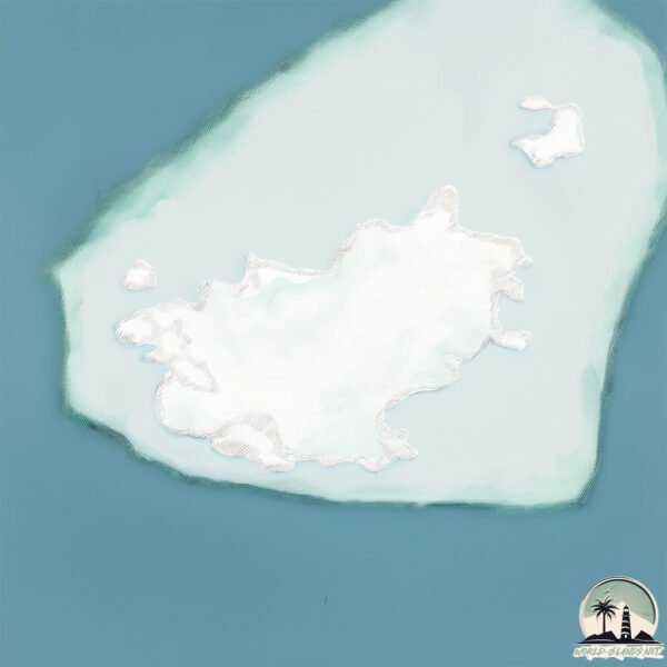
Geography and size of Antipodes
Size: 18.4 km²
Coastline: 42.7 km
Ocean: Pacific Ocean
Sea: South Pacific Ocean
Continent: Oceania
Antipodes is a Medium Island spanning 18 km² with a coastline of 43 km.
Archipel: –
Tectonic Plate: Pacific – The world’s largest tectonic plate, covering much of the Pacific Ocean, known for the Pacific Ring of Fire with extensive seismic and volcanic activity.
The geographic heart of the island is pinpointed at these coordinates:
Latitude: -49.68711105 / Longitude: 178.7742065
Climate and weather of Antipodes
Climate Zone: Polar
Climate Details: Tundra
Temperature: Cold
Climate Characteristics: The tundra climate features long, extremely cold winters and short, cool summers. Vegetation is limited to mosses, lichens, and small shrubs due to the low temperatures and short growing seasons. Biodiversity is low, but some specialized species thrive.
Topography and nature of Antipodes
Timezone: UTC+12:00
Timezone places: Pacific/Auckland
Max. Elevation: 304 m
Mean Elevation: 167 m
Vegetation: Evergreen Broadleaf Forest
Tree Coverage: 43%
The mean elevation is 167 m. The highest elevation on the island reaches approximately 304 meters above sea level. The island is characterized by Hills: Gently sloping landforms with rounded tops, having a maximum elevation between 200 and 500 meters. Hills contribute to a varied landscape on islands.
Dominating Vegetation: Evergreen Broadleaf Forest
Characterized by dense, lush canopies of broadleaf trees that retain their leaves year-round. These forests are typically found in tropical and subtropical regions and are known for their high biodiversity. Antipodes has a tree cover of 43 %.
Vegetation: 5 vegetation zones – Highly Diverse Island
With five different vegetation zones, these islands offer a rich tapestry of ecosystems. The variety could include dense forests, open meadows, wetlands, coastal zones, and more. This level of diversity supports an intricate web of life, with each zone playing a vital role in the overall ecological health and balance of the island.
Infrastructure and Travelling to Antipodes
Does the island have a public airport? no.
There is no public and scheduled airport on Antipodes. The nearest airport is Christchurch International Airport, located 974 km away.
Does the island have a major port? no.
There are no major ports on Antipodes. The closest major port is AKAROA, approximately 915 km away.
The mean population of Antipodes is 0 per km². Antipodes is Uninhabited. The island belongs to New Zealand.
Continuing your journey, Arapawa is the next notable island, situated merely km away.
Winter in the Subantarctic: Antipodes Island terrestrial ecology
Winter in the Subantarctic: Antipodes Island terrestrial ecology is a short film about the history of Antipodes Island and the work ...Winter in the Subantarctic: Antipodes Island terrestrial ecology
Winter in the Subantarctic: Antipodes Island terrestrial ecology is a ...
Winter in the Subantarctic: Antipodes Island terrestrial ecology is a short film about the history of Antipodes Island and the work ...
World’s biggest mouse hunt underway on remote Antipodes Island
A troop of 10 rangers, three sniffer dogs and the crew of HMNZS ...
A troop of 10 rangers, three sniffer dogs and the crew of HMNZS Wellington made the trip south for 'Operation Endurance' this ...
Exploring the Remote Life of Antipodes Island
Take a journey to New Zealand's Antipodes Island, a remote nature ...
Take a journey to New Zealand's Antipodes Island, a remote nature reserve with rich biodiversity and no permanent human ...
SmartShelters DOC Antipodes Helicopter Hangar Installation & Testimonial
The Department of Conservation employed SmartShelters to create a ...
The Department of Conservation employed SmartShelters to create a helicopter hangar and accommodation shelters for use in ...
🇳🇿New Zealand Southern Pacific Ocean Antipodes Island Google Earth and Google Maps#mapguide #travel
Southern Pacific Ocean Antipodes Island New Zealand in Google Earth ...
Southern Pacific Ocean Antipodes Island New Zealand in Google Earth and Google Maps#mapguide #travel.
Antipodes Island finally free of rodents
One of New Zealand's most remote islands, Antipodes Island, is ...
One of New Zealand's most remote islands, Antipodes Island, is officially free of the 200000 mice that once lived there.
Illegal islands that you can’t visit…😰 #shorts
14/07/16 Antipodes Island - SubAntarctic Weather
14th of July, a rough day of weather on the Antipodes Islands - not a ...
14th of July, a rough day of weather on the Antipodes Islands - not a day to land a dinghy in Hut Cove below the hut!
The other side of the Earth! Mal of Antipodes #geography
Antipodes!
Antipodes!
This is the World's Most Remote Island..
The World's Most Remote Islands are the Pitcairn Islands located in ...
The World's Most Remote Islands are the Pitcairn Islands located in the south pacific ocean. The town here is known as ...
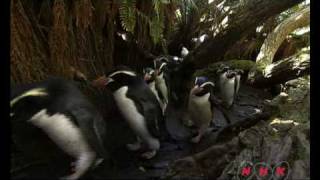
New Zealand Sub-Antarctic Islands (UNESCO/NHK)
The New Zealand Sub-Antarctic Islands consist of five island groups ...
The New Zealand Sub-Antarctic Islands consist of five island groups (the Snares, Bounty Islands, Antipodes Islands, Auckland ...
Antipodes Islands New Zealand
Exploring the Mysteries of Antipodes Island
Explore the remote Antipodes Island, highlighting its unique flora and ...
Explore the remote Antipodes Island, highlighting its unique flora and rare bird species, along with historical ocean tribes' survival ...
Introduced house mouse on Antipodes Island
Introduced house mouse in Anchorage Bay, Antipodes Island. Mice were ...
Introduced house mouse in Anchorage Bay, Antipodes Island. Mice were introduced to Antipodes Island at the start of the 20th ...
Antipodes Island parakeet - New Zealand Bird of the Week
Antipodes Island parakeets are unmistakable, uniformly green birds ...
Antipodes Island parakeets are unmistakable, uniformly green birds that are notable for being New Zealand's second known ...
Exploration of the Antipodes
VIDEO HOSTED ON BEHALF OF ORION EXPEDITIONS. Isolated, windswept, ...
VIDEO HOSTED ON BEHALF OF ORION EXPEDITIONS. Isolated, windswept, beautiful and fragile, New Zealand?s sub-Antarctic ...
Site levelling - Antipodes Island
In order to build a temporary helicopter hangar to hold the machines ...
In order to build a temporary helicopter hangar to hold the machines during a sub-antarctic winter a level site is required. A large ...
Antipodes Islands by Night
Turn your volume up and listen to the Antipodes Islands by night. ...
Turn your volume up and listen to the Antipodes Islands by night. Hundreds of petrels and seabirds were whizzing around our ...
Reischek's Parakeet - Antipodes Island NZ
New Zealand’s Antipodes Islands – remote, wild, and special | Our Changing World
An ambitious project to rid the remote Antipodes Island of introduced ...
An ambitious project to rid the remote Antipodes Island of introduced mice proved successful in 2018. Claire Concannon visits the ...
Antipodean Albatross - Antipodes Island NZ
ANTIPODES ISLANDS New Zealand Short 000060 Arhn global
Why NOBODY Wants These Islands? #shorts #geography #map #education
Do you think Earth is all neatly divided up into countries? Some ...
Do you think Earth is all neatly divided up into countries? Some places defy the rules. Take Bir Tawil—this patch of land between ...
Antipodes Island, New Zealand Beautiful island
The Antipodes Islands (from Greek αντίποδες - antipodes) are ...
The Antipodes Islands (from Greek αντίποδες - antipodes) are inhospitable and uninhabited volcanic islands in subantarctic ...
Getting the Kitchen Sink On the Antipodes Islands
In August, a team of builders and scientists went to the Antipodes ...
In August, a team of builders and scientists went to the Antipodes Islands to repair the main hut, which was severely damaged in a ...
New Zealand is classified as Developed region: G7: Group of Seven – Major advanced economies, including Canada, France, Germany, Italy, Japan, the United Kingdom, and the United States. The level of income is High income: OECD.
News – Latest Updates and Headlines from Antipodes
Stay informed with the most recent news and important headlines from Antipodes. Here’s a roundup of the latest developments.
Loading...
Please note: The data used here has been primarily extracted from satellite readings. Deviations from exact values may occur, particularly regarding the height of elevations and population density. Land area and coastline measurements refer to average values at mean high tide.