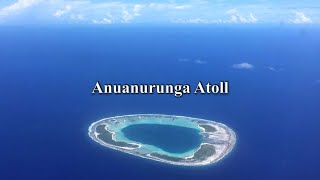
Anuanurunga

Welcome to Anuanurunga, a Tropical island in the South Pacific Ocean, part of the majestic Pacific Ocean. This guide offers a comprehensive overview of what makes Anuanurunga unique – from its geography and climate to its population, infrastructure, and beyond. Dive into the details:
- Geography and Size: Explore the island’s size and location.
- Climate and Weather: Weather patterns and temperature.
- Topography and Nature: Uncover the natural wonders of the island.
- Infrastructure and Travelling: Insights on reaching, staying, and making the most of your visit.
- News and Headlines: Latest News.
Geography and size of Anuanurunga
Size: 1.51 km²
Coastline: 7.6 km
Ocean: Pacific Ocean
Sea: South Pacific Ocean
Continent: Oceania
Anuanurunga is a Small Island spanning 1.5 km² with a coastline of 7.6 km.
Archipel: Polynesia – A region of more than 1,000 islands in the central and southern Pacific Ocean, known for their diverse Polynesian cultures, stunning landscapes, and marine biodiversity.
Tectonic Plate: Tonga – Part of the Pacific Ring of Fire, the Tonga Plate is known for its deep ocean trenches and subduction zones. It’s located in the southwestern Pacific Ocean and is primarily oceanic.
The geographic heart of the island is pinpointed at these coordinates:
Latitude: -20.60631408 / Longitude: -143.28533606
Climate and weather of Anuanurunga
Climate Zone: Tropical
Climate Details: Tropical Rainforest Climate
Temperature: Hot
Climate Characteristics: This climate is typified by heavy rainfall throughout the year, high humidity, and consistently high temperatures, leading to lush rainforests and rich biodiversity. Seasonal temperature variations are minimal.
Topography and nature of Anuanurunga
Timezone: UTC-10:00
Timezone places: Pacific/Honolulu
Max. Elevation: -1 m
Mean Elevation: -3 m
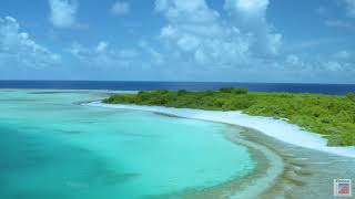
Vegetation: Rocky Terrain
Tree Coverage: 56%
The mean elevation is -3 m. Remarkably, this unique island barely emerges above the sea level, showcasing nature’s fascinating interplay with the ocean. The island is characterized by Plains: Flat, low-lying lands characterized by a maximum elevation of up to 200 meters. On islands, plains are typically coastal lowlands or central flat areas.
Dominating Vegetation: Rocky Terrain
Landscapes dominated by gravel, rock, and stone, with little to no vegetation. These areas are often found in mountainous regions or deserts. Anuanurunga has a tree cover of 56 %.
Vegetation: 2 vegetation zones – Low Diversity Island
Islands with two distinct vegetation zones offer slightly more ecological variety. These zones could be due to differences in elevation, moisture, or other environmental factors. While still limited in biodiversity, these islands may offer a contrast between the two zones, such as a coastline with mangroves and an inland area with grassland.
Infrastructure and Travelling to Anuanurunga
Does the island have a public airport? no.
There is no public and scheduled airport on Anuanurunga. The nearest airport is Hao Airport, located 382 km away.
Does the island have a major port? no.
There are no major ports on Anuanurunga. The closest major port is PAPEETE, approximately 777 km away.
The mean population of Anuanurunga is 2 per km². Anuanurunga is Gently Populated. The island belongs to France.
Continuing your journey, Tematangi is the next notable island, situated merely km away.
0069 Anuanurunga Atoll|Private Island for Sale in French Polynesia

France is classified as Developed region: G7: Group of Seven – Major advanced economies, including Canada, France, Germany, Italy, Japan, the United Kingdom, and the United States. The level of income is High income: OECD.
News – Latest Updates and Headlines from Anuanurunga
Stay informed with the most recent news and important headlines from Anuanurunga. Here’s a roundup of the latest developments.
Please note: The data used here has been primarily extracted from satellite readings. Deviations from exact values may occur, particularly regarding the height of elevations and population density. Land area and coastline measurements refer to average values at mean high tide.