Welcome to Atoll Rangiroa, a Tropical island in the South Pacific Ocean, part of the majestic Pacific Ocean. This guide offers a comprehensive overview of what makes Atoll Rangiroa unique – from its geography and climate to its population, infrastructure, and beyond. Dive into the details:
Geography and size of Atoll Rangiroa
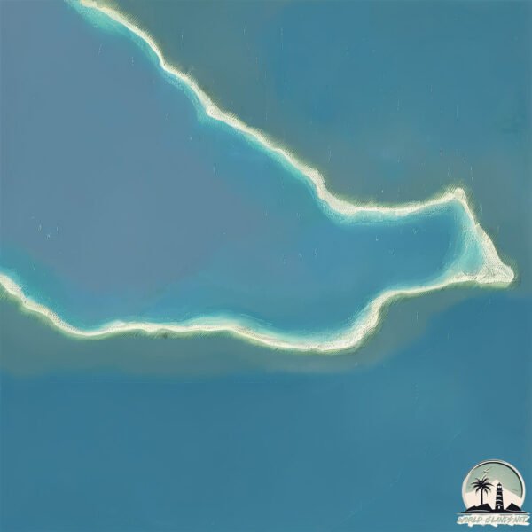
Size: 3.208 km²
Coastline: 16.7 km
Ocean: Pacific Ocean
Sea: South Pacific Ocean
Continent: Oceania
Atoll Rangiroa is a Small Island spanning 3.2 km² with a coastline of 16.7 km.
Archipel: Tuamotus – A group of atolls in French Polynesia, known for their stunning coral reefs, lagoons, and as a popular diving destination.
Tectonic Plate: Pacific – The world’s largest tectonic plate, covering much of the Pacific Ocean, known for the Pacific Ring of Fire with extensive seismic and volcanic activity.
The geographic heart of the island is pinpointed at these coordinates:
Latitude: -15.27198708 / Longitude: -147.36044723
Climate and weather of Atoll Rangiroa
Climate Zone: Tropical
Climate Details: Tropical Rainforest Climate
Temperature: Hot
Climate Characteristics: This climate is typified by heavy rainfall throughout the year, high humidity, and consistently high temperatures, leading to lush rainforests and rich biodiversity. Seasonal temperature variations are minimal.
Topography and nature of Atoll Rangiroa
Timezone: UTC-10:00
Timezone places: Pacific/Honolulu
Max. Elevation: 5 m
Mean Elevation: 4 m
Vegetation: Sandy Terrain
Tree Coverage: 47%
The mean elevation is 4 m. The highest elevation on the island reaches approximately 5 meters above sea level. The island is characterized by Plains: Flat, low-lying lands characterized by a maximum elevation of up to 200 meters. On islands, plains are typically coastal lowlands or central flat areas.
Dominating Vegetation: Sandy Terrain
Areas covered primarily with sand, like dunes and beaches, where vegetation is sparse due to the dry and shifting substrate. Atoll Rangiroa has a tree cover of 47 %.
Vegetation: 9 vegetation zones – Very Highly Diverse Island
Islands in this range are ecological powerhouses, showcasing a wide array of vegetation zones. Each zone, from lush rainforests to arid scrublands, coastal mangroves to mountainous regions, contributes to a complex and interdependent ecosystem. These islands are often hotspots of biodiversity, supporting numerous species and intricate ecological processes.
Infrastructure and Travelling to Atoll Rangiroa
Does the island have a public airport? no.
There is no public and scheduled airport on Atoll Rangiroa. The nearest airport is Rangiroa Airport, located 46 km away.
Does the island have a major port? no.
There are no major ports on Atoll Rangiroa. The closest major port is PAPEETE, approximately 342 km away.
The mean population of Atoll Rangiroa is 29 per km². Atoll Rangiroa is Gently Populated. The island belongs to France.
Continuing your journey, Motu Mahitu is the next notable island, situated merely km away.
Fakarava vs. Rangiroa: Picking the Perfect Atoll for Your Next Getaway!
Dive into the beauty and allure of the Tuamotu Archipelago in French Polynesia as we put two of its most stunning atolls ...Fakarava vs. Rangiroa: Picking the Perfect Atoll for Your Next Getaway!
Dive into the beauty and allure of the Tuamotu Archipelago in French ...
Dive into the beauty and allure of the Tuamotu Archipelago in French Polynesia as we put two of its most stunning atolls ...
Rangiroa Island - Exploring an Affordable Atoll in French Polynesia
Rangiroa Travel Vlog | Day trip to Blue Lagoon and Our stay at Hotel ...
Rangiroa Travel Vlog | Day trip to Blue Lagoon and Our stay at Hotel Kia Ora Resort & Spa in French Polynesia We're so excited ...
RANGIROA Island, French Polynesia's best scuba diving sites.
There are two Islands in French Polynesia not to be missed by scuba ...
There are two Islands in French Polynesia not to be missed by scuba divers, Rangiroa and Fakarava. Here you can find the super ...
Rangiroa Atoll | 4K Walking Tour of One of the World’s Largest Lagoons
Welcome to Rangiroa, one of the largest atolls in the world and a true ...
Welcome to Rangiroa, one of the largest atolls in the world and a true gem of French Polynesia In this 4K walking tour, we ...
Top 10 Things to Do in Rangiroa – Don't Miss These Before You Travel to French Polynesia!
Our full blog guide: ...
Unbelievable Secrets of Rangiroa Atoll!
Rangiroa- the biggest atoll in French Polynesia. Blue Lagoon
Welcome to Rangiroa – one of the largest atolls in the world, and a ...
Welcome to Rangiroa – one of the largest atolls in the world, and a true jewel of French Polynesia. Unlike the steep green ...
Traveling to a CRAZY BLUE Lagoon! - Rangiroa Travel Guide
My name is Chantae. I'm a professional travel writer who has been ...
My name is Chantae. I'm a professional travel writer who has been living in the South Pacific for the past five years. Come with me ...
"Top 5 Must-Do Day Trips in Rangiroa: Unveiling French Polynesia's Hidden Gem!"
Welcome to Rangiroa, the crown jewel of French Polynesia's Tuamotu ...
Welcome to Rangiroa, the crown jewel of French Polynesia's Tuamotu Archipelago and the world's largest atoll! Prepare to be ...
Rangiroa Revealed: A Traveler's Guide to the Hidden Gem of French Polynesia
Join us as we uncover the secrets of Rangiroa, a stunning atoll in ...
Join us as we uncover the secrets of Rangiroa, a stunning atoll in French Polynesia's Tuamotu Archipelago, nestled in the Pacific ...
The biggest atoll of French Polynesia -Rangiroa #travel #rangiroa #nature #beach
"Rangiroa Revealed: Your Ultimate Guide to Exploring French Polynesia's Enchanting Atoll!"
Welcome to Rangiroa, the jewel of the Tuamotu Archipelago in French ...
Welcome to Rangiroa, the jewel of the Tuamotu Archipelago in French Polynesia! This breathtaking atoll, surrounded by ...
Rangiroa or Fakarava? Decoding the Best Polynesian Atoll for Your Visit
Exploring the Tuamotu Archipelago in French Polynesia? Dive into our ...
Exploring the Tuamotu Archipelago in French Polynesia? Dive into our comparison of its two crown jewels: Rangiroa and ...
Things to do in Rangiroa, French Polynesia
The best things to do in #Rangiroa, #FrenchPolynesia, including ...
The best things to do in #Rangiroa, #FrenchPolynesia, including #diving the #TiputaPass, snorkelling and a trip to the Blue ...
Rangiroa, Tahiti: The World's Hidden Atoll Paradise
Dive into the mesmerizing beauty of Rangiroa, one of the world's ...
Dive into the mesmerizing beauty of Rangiroa, one of the world's largest atolls situated in Tahiti's Tuamotu Archipelago. Whether ...
Paradise Found in Rangiroa – French Polynesia Magic
Welcome to Rangiroa, a breathtaking atoll in French Polynesia! ...
Welcome to Rangiroa, a breathtaking atoll in French Polynesia! Crystal-clear waters, vibrant reefs, and island calm await you in ...
"Dive Into Paradise: Exploring the Stunning Rangiroa Lagoon in French Polynesia"
Join us on a breathtaking journey to the heart of French Polynesia's ...
Join us on a breathtaking journey to the heart of French Polynesia's Tuamotu Archipelago, where the picturesque atoll of ...
"Rangiroa Snorkeling Adventure: Discovering the World's Second Largest Atoll"
"Dive into an unforgettable snorkeling experience in Rangiroa, located ...
"Dive into an unforgettable snorkeling experience in Rangiroa, located in the heart of French Polynesia's Tuamotu Archipelago.
RANGIROA ATOLL - A PERFECT PARADISE | Around The World in 80 Islands | Polynesia Travel Guide
The travel guide to POLYNESIA! Five archipelagos covered by blooming ...
The travel guide to POLYNESIA! Five archipelagos covered by blooming vegetation and surrounded by crystal clear waters, such ...
"Discover Rangiroa: 5 Hidden Gems of French Polynesia's Tuamotu Archipelago!"
Embark on a journey to the heart of French Polynesia with our deep ...
Embark on a journey to the heart of French Polynesia with our deep dive into Rangiroa, a breathtaking atoll in the Tuamotu ...
Diving Rangiroa Atoll - French Polynesia
Check out the excitement of being pushed through a channel by a ...
Check out the excitement of being pushed through a channel by a massive current! An underwater roller coaster!
Rangiroa vs. Tikehau: Which French Polynesian Atoll is Perfect for You?
Situated in the Tuamotu Archipelago, Rangiroa and Tikehau are two gems ...
Situated in the Tuamotu Archipelago, Rangiroa and Tikehau are two gems of French Polynesia. Both offer stunning landscapes, ...
Rangiroa Island: Dive into the Heart of Polynesian Paradise!
Embark on a journey to Rangiroa Island, a gem in the Tuamotu ...
Embark on a journey to Rangiroa Island, a gem in the Tuamotu Archipelago of French Polynesia. Discover why this island is a ...
French Polynesia Rangiroa Island Aerial View Of Motu Atoll In French Polynesia Features A Narrow
French Polynesia Rangiroa Island Aerial View Of Motu Atoll In French ...
French Polynesia Rangiroa Island Aerial View Of Motu Atoll In French Polynesia Features A Narrow Land Strip Covered In ...
RANGIROA 🗺️ - Discover the Pearl of the Tuamotu! #Rangiroa
Guide ⬇️ ✨ THE PEARL OF THE TUAMOTU - FRENCH POLYNESIA 🛏️ Kia Ora ...
Guide ⬇️ ✨ THE PEARL OF THE TUAMOTU - FRENCH POLYNESIA 🛏️ Kia Ora Resort & Spa ➤ Luxurious haven nestled ...
France is classified as Developed region: G7: Group of Seven – Major advanced economies, including Canada, France, Germany, Italy, Japan, the United Kingdom, and the United States. The level of income is High income: OECD.
News – Latest Updates and Headlines from Atoll Rangiroa
Stay informed with the most recent news and important headlines from Atoll Rangiroa. Here’s a roundup of the latest developments.
Loading...
Please note: The data used here has been primarily extracted from satellite readings. Deviations from exact values may occur, particularly regarding the height of elevations and population density. Land area and coastline measurements refer to average values at mean high tide.