Atoll Ravahere
Welcome to Atoll Ravahere, a Tropical island in the South Pacific Ocean, part of the majestic Pacific Ocean. This guide offers a comprehensive overview of what makes Atoll Ravahere unique – from its geography and climate to its population, infrastructure, and beyond. Dive into the details:
- Geography and Size: Explore the island’s size and location.
- Climate and Weather: Weather patterns and temperature.
- Topography and Nature: Uncover the natural wonders of the island.
- Infrastructure and Travelling: Insights on reaching, staying, and making the most of your visit.
- News and Headlines: Latest News.
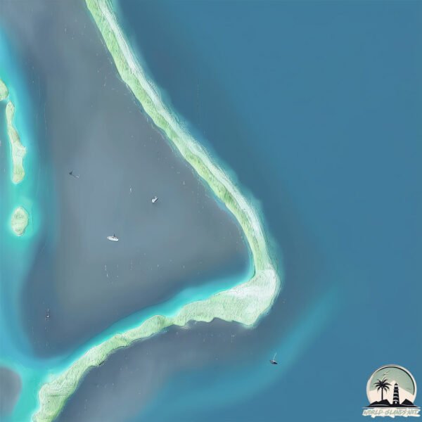
Geography and size of Atoll Ravahere
Size: 2.849 km²
Coastline: 21 km
Ocean: Pacific Ocean
Sea: South Pacific Ocean
Continent: Oceania
Atoll Ravahere is a Small Island spanning 2.8 km² with a coastline of 21 km.
Archipel: Tuamotus – A group of atolls in French Polynesia, known for their stunning coral reefs, lagoons, and as a popular diving destination.
Tectonic Plate: Pacific – The world’s largest tectonic plate, covering much of the Pacific Ocean, known for the Pacific Ring of Fire with extensive seismic and volcanic activity.
The geographic heart of the island is pinpointed at these coordinates:
Latitude: -18.24489639 / Longitude: -142.1663286
Climate and weather of Atoll Ravahere
Climate Zone: Tropical
Climate Details: Tropical Rainforest Climate
Temperature: Hot
Climate Characteristics: This climate is typified by heavy rainfall throughout the year, high humidity, and consistently high temperatures, leading to lush rainforests and rich biodiversity. Seasonal temperature variations are minimal.
Topography and nature of Atoll Ravahere
Timezone: UTC-10:00
Timezone places: Pacific/Honolulu
Max. Elevation: 1 m
Mean Elevation: -15 m
Vegetation: Shrubland
Tree Coverage: 95%
The mean elevation is -15 m. The highest elevation on the island reaches approximately 1 meters above sea level. The island is characterized by Plains: Flat, low-lying lands characterized by a maximum elevation of up to 200 meters. On islands, plains are typically coastal lowlands or central flat areas.
Dominating Vegetation: Shrubland
Dominated by shrubs and small bushes, these areas are typical in dry, rocky, or sandy environments, as well as in regions with poor soil fertility. Atoll Ravahere has a tree cover of 95 %.
Vegetation: 6 vegetation zones – Very Highly Diverse Island
Islands in this range are ecological powerhouses, showcasing a wide array of vegetation zones. Each zone, from lush rainforests to arid scrublands, coastal mangroves to mountainous regions, contributes to a complex and interdependent ecosystem. These islands are often hotspots of biodiversity, supporting numerous species and intricate ecological processes.
Infrastructure and Travelling to Atoll Ravahere
Does the island have a public airport? no.
There is no public and scheduled airport on Atoll Ravahere. The nearest airport is Hao Airport, located 133 km away.
Does the island have a major port? no.
There are no major ports on Atoll Ravahere. The closest major port is PAPEETE, approximately 823 km away.
The mean population of Atoll Ravahere is 13 per km². Atoll Ravahere is Gently Populated. The island belongs to France.
Continuing your journey, Ahunui is the next notable island, situated merely km away.
Atoll Toau - Tuamotus Islands - French Polynesia - Full HD


France is classified as Developed region: G7: Group of Seven – Major advanced economies, including Canada, France, Germany, Italy, Japan, the United Kingdom, and the United States. The level of income is High income: OECD.
News – Latest Updates and Headlines from Atoll Ravahere
Stay informed with the most recent news and important headlines from Atoll Ravahere. Here’s a roundup of the latest developments.
Please note: The data used here has been primarily extracted from satellite readings. Deviations from exact values may occur, particularly regarding the height of elevations and population density. Land area and coastline measurements refer to average values at mean high tide.