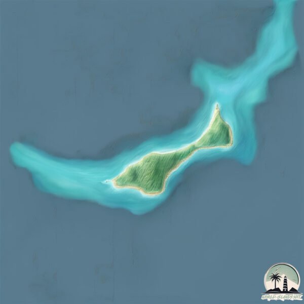
Aukena
Welcome to Aukena, a Tropical island in the South Pacific Ocean, part of the majestic Pacific Ocean. This guide offers a comprehensive overview of what makes Aukena unique – from its geography and climate to its population, infrastructure, and beyond. Dive into the details:
- Geography and Size: Explore the island’s size and location.
- Climate and Weather: Weather patterns and temperature.
- Topography and Nature: Uncover the natural wonders of the island.
- Infrastructure and Travelling: Insights on reaching, staying, and making the most of your visit.
- News and Headlines: Latest News.
Geography and size of Aukena
Size: 1.555 km²
Coastline: 9.6 km
Ocean: Pacific Ocean
Sea: South Pacific Ocean
Continent: Oceania
Aukena is a Small Island spanning 1.6 km² with a coastline of 9.6 km.
Archipel: Gambier Islands – Located in the southeastern part of French Polynesia, these islands are known for their remote beauty and vibrant marine life.
Tectonic Plate: South America – A major plate covering the South American continent and part of the Atlantic Ocean, known for the Andes mountain range and significant seismic and volcanic activity.
The geographic heart of the island is pinpointed at these coordinates:
Latitude: -23.13230242 / Longitude: -134.90486213
Climate and weather of Aukena
Climate Zone: Tropical
Climate Details: Tropical Rainforest Climate
Temperature: Hot
Climate Characteristics: This climate is typified by heavy rainfall throughout the year, high humidity, and consistently high temperatures, leading to lush rainforests and rich biodiversity. Seasonal temperature variations are minimal.
Topography and nature of Aukena
Timezone: UTC-10:00
Timezone places: Pacific/Honolulu
Max. Elevation: 41 m
Mean Elevation: 34 m
Vegetation: Evergreen Broadleaf Forest
Tree Coverage: 47%
The mean elevation is 34 m. The highest elevation on the island reaches approximately 41 meters above sea level. The island is characterized by Plains: Flat, low-lying lands characterized by a maximum elevation of up to 200 meters. On islands, plains are typically coastal lowlands or central flat areas.
Dominating Vegetation: Evergreen Broadleaf Forest
Characterized by dense, lush canopies of broadleaf trees that retain their leaves year-round. These forests are typically found in tropical and subtropical regions and are known for their high biodiversity. Aukena has a tree cover of 47 %.
Vegetation: 2 vegetation zones – Low Diversity Island
Islands with two distinct vegetation zones offer slightly more ecological variety. These zones could be due to differences in elevation, moisture, or other environmental factors. While still limited in biodiversity, these islands may offer a contrast between the two zones, such as a coastline with mangroves and an inland area with grassland.
Infrastructure and Travelling to Aukena
Does the island have a public airport? no.
There is no public and scheduled airport on Aukena. The nearest airport is Totegegie Airport, located 4 km away.
Does the island have a major port? no.
There are no major ports on Aukena. The closest major port is PORT RIKITEA, approximately 5 km away.
The mean population of Aukena is 21 per km². Aukena is Gently Populated. The island belongs to France.
Continuing your journey, Mangareva is the next notable island, situated merely km away.
LES GAMBIER AUKENA


France is classified as Developed region: G7: Group of Seven – Major advanced economies, including Canada, France, Germany, Italy, Japan, the United Kingdom, and the United States. The level of income is High income: OECD.
News – Latest Updates and Headlines from Aukena
Stay informed with the most recent news and important headlines from Aukena. Here’s a roundup of the latest developments.
Please note: The data used here has been primarily extracted from satellite readings. Deviations from exact values may occur, particularly regarding the height of elevations and population density. Land area and coastline measurements refer to average values at mean high tide.