Welcome to Avoid Island, a Tropical island in the Coral Sea, part of the majestic Pacific Ocean. This guide offers a comprehensive overview of what makes Avoid Island unique – from its geography and climate to its population, infrastructure, and beyond. Dive into the details:
Geography and size of Avoid Island
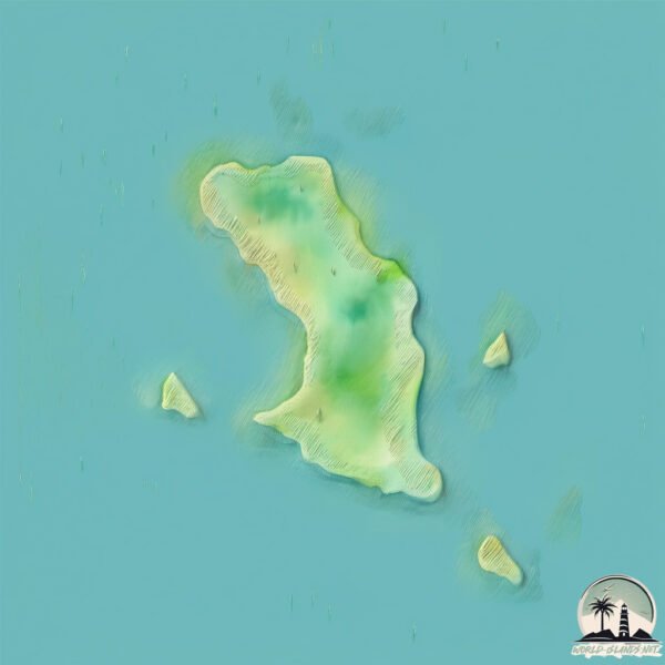
Size: 1.229 km²
Coastline: 6.1 km
Ocean: Pacific Ocean
Sea: Coral Sea
Continent: Oceania
Avoid Island is a Small Island spanning 1.2 km² with a coastline of 6.1 km.
Archipel: –
Tectonic Plate: Australia – A major tectonic plate covering Australia, New Zealand, and parts of the Indian and Pacific Oceans, known for its relative stability and occasional seismic activity.
The geographic heart of the island is pinpointed at these coordinates:
Latitude: -21.97451635 / Longitude: 149.66220725
Climate and weather of Avoid Island
Climate Zone: Tropical
Climate Details: Tropical Savanna, Wet
Temperature: Hot
Climate Characteristics: Defined by distinct wet and dry seasons with high temperatures year-round. Pronounced rainfall occurs during the wet season, while the dry season is marked by drought.
Topography and nature of Avoid Island
Timezone: UTC+10:00
Timezone places: Australia/Sydney
Max. Elevation: 8 m
Mean Elevation: 7 m
Vegetation: Evergreen Broadleaf Forest
Tree Coverage: 98%
The mean elevation is 7 m. The highest elevation on the island reaches approximately 8 meters above sea level. The island is characterized by Plains: Flat, low-lying lands characterized by a maximum elevation of up to 200 meters. On islands, plains are typically coastal lowlands or central flat areas.
Dominating Vegetation: Evergreen Broadleaf Forest
Characterized by dense, lush canopies of broadleaf trees that retain their leaves year-round. These forests are typically found in tropical and subtropical regions and are known for their high biodiversity. Avoid Island has a tree cover of 98 %.
Vegetation: 2 vegetation zones – Low Diversity Island
Islands with two distinct vegetation zones offer slightly more ecological variety. These zones could be due to differences in elevation, moisture, or other environmental factors. While still limited in biodiversity, these islands may offer a contrast between the two zones, such as a coastline with mangroves and an inland area with grassland.
Infrastructure and Travelling to Avoid Island
Does the island have a public airport? no.
There is no public and scheduled airport on Avoid Island. The nearest airport is Mackay Airport, located 103 km away.
Does the island have a major port? no.
There are no major ports on Avoid Island. The closest major port is HAY POINT, approximately 86 km away.
The mean population of Avoid Island is 0 per km². Avoid Island is Uninhabited. The island belongs to Australia.
Continuing your journey, Allandale is the next notable island, situated merely km away.
Avoid Island
DJI, Phantom 4, Queensland, Australia, Mackay, aerial, drone, island, tropical.Avoid Island
DJI, Phantom 4, Queensland, Australia, Mackay, aerial, drone, island, ...
DJI, Phantom 4, Queensland, Australia, Mackay, aerial, drone, island, tropical.
Avoid Island Real World Learning on the Reef
Come along to Avoid Island and we will tell you about our turtle ...
Come along to Avoid Island and we will tell you about our turtle conservation and education programs.
Avoid Island from above
Drone footage by Nicholas Shera.
Drone footage by Nicholas Shera.
Wonder of Science and QTFN Avoid Island trip
This January, seven Year 9 students from across regional Queensland, ...
This January, seven Year 9 students from across regional Queensland, Australia had the opportunity to participate in two days of ...
Avoid Island - We Ate Sand (KARP)
Rock Against Everything @ Petersham Bowling Club.
Rock Against Everything @ Petersham Bowling Club.
Student shares his experience at conservation camp on Avoid Island
5 Islands You MUST Avoid!
Explore the top 5 most dangerous and deserted islands on Earth that ...
Explore the top 5 most dangerous and deserted islands on Earth that you should never visit! From deadly creatures to haunting ...
Scientists on Avoid Island prepare for the flatback turtle breeding season
13/11/2016 The world's only privately owned turtle rookery is home to ...
13/11/2016 The world's only privately owned turtle rookery is home to the flatback turtle on Avoid Island.
AVOID Island Hopping In Philippines?! (WATCH THIS BEFORE YOU VISIT) 🇵🇭
Thank you so much for all the love and the support. You have no idea ...
Thank you so much for all the love and the support. You have no idea how much this mean to me. We put so much hard work and ...
The Most Dangerous Islands to Avoid
While some islands are paradise, others are better left unexplored. ...
While some islands are paradise, others are better left unexplored. From treacherous wildlife to extreme weather and perilous ...
People Go to this Island to Die #shorts #mystery
7 DANGEROUS ISLANDS YOU SHOULD AVOID
The Most Dangerous Islands to Avoid | Travel Guide
Which islands are the most dangerous places on Earth? In this video, ...
Which islands are the most dangerous places on Earth? In this video, we reveal the top 10 most dangerous islands you should ...
5 Mistakes to Avoid When Planning a Trip to the Cook Islands
Planning a trip to the Cook Islands? Avoid these 5 common mistakes to ...
Planning a trip to the Cook Islands? Avoid these 5 common mistakes to ensure your journey is as smooth and enjoyable as ...
Baby flatback turtle - Avoid Island, Queensland, Australia
A flatback turtle hatchling makes its way to the Coral Sea for the ...
A flatback turtle hatchling makes its way to the Coral Sea for the first time! This hatchling was born on Avoid Island in the Great ...
Avoid Island - Dumbest Bull at the Rodeo
Rock Against Everything @ Petersham Bowling Club.
Rock Against Everything @ Petersham Bowling Club.
4 things to know before you first trip to Maldives 🏝
Cr: TikTok@voyagefox TikTok@bestiewanderer TikTok@catchagypsea ...
Cr: TikTok@voyagefox TikTok@bestiewanderer TikTok@catchagypsea TikTok@michutravel #maldives #travel2023.
Avoid these scams while visiting the Gili Islands on Bali #giliair #bali #gili #indonesia #island
Avoid Island - One Hand Clapping
Rock Against Everything @ Petersham Bowling Club.
Rock Against Everything @ Petersham Bowling Club.
AVOID THESE 3 COMMON CHARTER MISTAKES IN GREEK ISLANDS
Avoid These Common Yacht Mistakes in the Greek Islands! ...
Avoid These Common Yacht Mistakes in the Greek Islands! #YachtCharterTips #Yacht #GreekIslands.
DON'T DO THIS in the Gili Islands (7 things to avoid)
These are 7 important things you should NOT do if you're planning to ...
These are 7 important things you should NOT do if you're planning to visit the Gili Islands in Indonesia. Don't make the same ...
Phu Quoc Island VIETNAM Itinerary MISTAKES to Avoid
Phu Quoc Island VIETNAM Itinerary MISTAKES to Avoid #shorts ...
Phu Quoc Island VIETNAM Itinerary MISTAKES to Avoid #shorts #phuquocisland #vietnam #travel #trending #trendingshorts ...
Why you should avoid koh samet ? #youtubeshort #avoid #kohsamet , the best island in Thailand
In my opinion it's Probably the best island in Thailand.
In my opinion it's Probably the best island in Thailand.
Man spends 33 years alone in an island to avoid speaking to anyone #putybuty #trending
Avoid the crowds in this beautiful Greek island! #ios #greece
I can't believe everyone travels to Santorini, but they skip this ...
I can't believe everyone travels to Santorini, but they skip this beautiful Greek island only 30 minutes away by ferry! SUBSCRIBE!
Australia is classified as Developed region: nonG7: Developed economies outside of the Group of Seven, characterized by high income and advanced economic structures. The level of income is High income: OECD.
News – Latest Updates and Headlines from Avoid Island
Stay informed with the most recent news and important headlines from Avoid Island. Here’s a roundup of the latest developments.
Loading...
Please note: The data used here has been primarily extracted from satellite readings. Deviations from exact values may occur, particularly regarding the height of elevations and population density. Land area and coastline measurements refer to average values at mean high tide.