Avsa Adasi

Welcome to Avsa Adasi, a Temperate island in the Sea of Marmara, part of the majestic Atlantic Ocean. This guide offers a comprehensive overview of what makes Avsa Adasi unique – from its geography and climate to its population, infrastructure, and beyond. Dive into the details:
- Geography and Size: Explore the island’s size and location.
- Climate and Weather: Weather patterns and temperature.
- Topography and Nature: Uncover the natural wonders of the island.
- Infrastructure and Travelling: Insights on reaching, staying, and making the most of your visit.
- News and Headlines: Latest News.
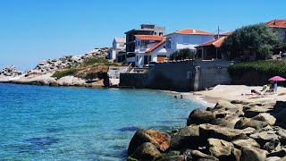
Geography and size of Avsa Adasi
Size: 21.3 km²
Coastline: 29.3 km
Ocean: Atlantic Ocean
Sea: Sea of Marmara
Continent: Asia
Avsa Adasi is a Medium Island spanning 21 km² with a coastline of 29 km.
Archipel: –
Tectonic Plate: Eurasia – One of the world’s largest tectonic plates, the Eurasian Plate covers a significant portion of Europe and Asia. It’s characterized by diverse geological features, including the Ural Mountains, the European Plain, and the Himalayas formed from its collision with the Indian Plate.
The geographic heart of the island is pinpointed at these coordinates:
Latitude: 40.50368507 / Longitude: 27.51124891
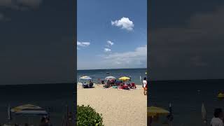
Climate and weather of Avsa Adasi
Climate Zone: Temperate
Climate Details: Hot-Summer Mediterranean Climate
Temperature: Hot Summer
Climate Characteristics: Characterized by hot, dry summers and mild, wet winters, typical of coastal areas with abundant sunshine.
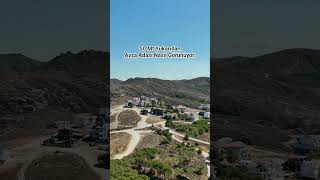
Topography and nature of Avsa Adasi
Timezone: UTC+02:00
Timezone places: Europe/Mariehamn
Max. Elevation: 113 m
Mean Elevation: 47 m
Vegetation: Agricultural Mosaic
Tree Coverage: 28%
The mean elevation is 47 m. The highest elevation on the island reaches approximately 113 meters above sea level. The island is characterized by Plains: Flat, low-lying lands characterized by a maximum elevation of up to 200 meters. On islands, plains are typically coastal lowlands or central flat areas.
Dominating Vegetation: Agricultural Mosaic
A mix of cropland and natural vegetation, often seen in rural landscapes where agricultural fields are interspersed with patches of natural habitats. Avsa Adasi has a tree cover of 28 %.
Vegetation: 7 vegetation zones – Very Highly Diverse Island
Islands in this range are ecological powerhouses, showcasing a wide array of vegetation zones. Each zone, from lush rainforests to arid scrublands, coastal mangroves to mountainous regions, contributes to a complex and interdependent ecosystem. These islands are often hotspots of biodiversity, supporting numerous species and intricate ecological processes.
Infrastructure and Travelling to Avsa Adasi
Does the island have a public airport? no.
There is no public and scheduled airport on Avsa Adasi. The nearest airport is Tekirdağ Çorlu Airport, located 80 km away.
Does the island have a major port? no.
There are no major ports on Avsa Adasi. The closest major port is KARABIGA, approximately 20 km away.
The mean population of Avsa Adasi is 44 per km². Avsa Adasi is Gently Populated. The island belongs to Turkey.
Continuing your journey, Pasalimani Adasi is the next notable island, situated merely km away.
Avşa Island Travel Guide 🇹🇷 | Beaches, Nightlife, History & Things to Do


Turkey is classified as Emerging region: MIKT: Mexico, Indonesia, South Korea, and Turkey – Economies recognized for their development potential and emerging market status. The level of income is Upper middle income.
News – Latest Updates and Headlines from Avsa Adasi
Stay informed with the most recent news and important headlines from Avsa Adasi. Here’s a roundup of the latest developments.
Please note: The data used here has been primarily extracted from satellite readings. Deviations from exact values may occur, particularly regarding the height of elevations and population density. Land area and coastline measurements refer to average values at mean high tide.