Welcome to Awaji Shima, a Temperate island in the Seto Naikai or Inland Sea, part of the majestic Pacific Ocean. This guide offers a comprehensive overview of what makes Awaji Shima unique – from its geography and climate to its population, infrastructure, and beyond. Dive into the details:
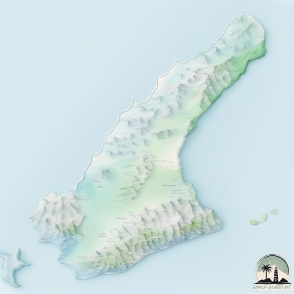
Geography and size of Awaji Shima
Size: 598.2 km²
Coastline: 187.9 km
Ocean: Pacific Ocean
Sea: Seto Naikai or Inland Sea
Continent: Asia
Awaji Shima is a Large Island spanning 598 km² with a coastline of 188 km.
Archipel: Japan – An East Asian archipelago comprising four main islands and numerous smaller ones, known for its rich history, technological advances, and distinct culture.
Tectonic Plate: Eurasia – One of the world’s largest tectonic plates, the Eurasian Plate covers a significant portion of Europe and Asia. It’s characterized by diverse geological features, including the Ural Mountains, the European Plain, and the Himalayas formed from its collision with the Indian Plate.
The geographic heart of the island is pinpointed at these coordinates:
Latitude: 34.36320278 / Longitude: 134.83851236
Climate and weather of Awaji Shima
Climate Zone: Temperate
Climate Details: Humid Subtropical Climate
Temperature: Hot Summer
Climate Characteristics: With continuous rainfall and hot summers, this climate is common in some coastal regions, supporting diverse vegetation.
Topography and nature of Awaji Shima
Timezone: UTC+09:00
Timezone places: Asia/Tokyo
Max. Elevation: 486 m
Mean Elevation: 122 m
Vegetation: Evergreen Broadleaf Forest
Tree Coverage: 47%
The mean elevation is 122 m. The highest elevation on the island reaches approximately 486 meters above sea level. The island is characterized by Hills: Gently sloping landforms with rounded tops, having a maximum elevation between 200 and 500 meters. Hills contribute to a varied landscape on islands.
Dominating Vegetation: Evergreen Broadleaf Forest
Characterized by dense, lush canopies of broadleaf trees that retain their leaves year-round. These forests are typically found in tropical and subtropical regions and are known for their high biodiversity. Awaji Shima has a tree cover of 47 %.
Vegetation: 13 vegetation zones – Exceptionally Diverse Island
Islands with more than ten vegetation zones are among the most ecologically rich and varied in the world. These islands are akin to miniature continents, boasting an incredible array of ecosystems. The sheer range of habitats, from high peaks to deep valleys, rainforests to deserts, creates a mosaic of life that is unparalleled. They are crucial for conservation and ecological studies.
Infrastructure and Travelling to Awaji Shima
Does the island have a public airport? no.
There is no public and scheduled airport on Awaji Shima. The nearest airport is Tokushima Awaodori Airport / JMSDF Tokushima Air Base, located 13 km away.
Does the island have a major port? no.
There are no major ports on Awaji Shima. The closest major port is KOBE, approximately 19 km away.
The mean population of Awaji Shima is 239 per km². Awaji Shima is Moderately Inhabited. The island belongs to Japan.
The name of the island resonates across different cultures and languages. Here is how it is known around the world: Arabic: شيكوكو; Spanish: Shikoku; French: Shikoku; Portuguese: Shikoku; Russian: Сикоку; Chinese: 四國
Continuing your journey, Kansai Airport is the next notable island, situated merely km away.
Awaji-shima island, the holy fortress Awaji island
The last samurai visits Awaji-shima island and introduces Izanagi jingu shrine, Sumoto castle and Uzushio, the famous whirlpool ...Awaji-shima island, the holy fortress Awaji island
The last samurai visits Awaji-shima island and introduces Izanagi ...
The last samurai visits Awaji-shima island and introduces Izanagi jingu shrine, Sumoto castle and Uzushio, the famous whirlpool ...
Awajishima Should Be On Your Next Japan Trip | In and Around Awajishima 4K #hyogo #awaji #japan
Hey guys, welcome back to my channel. In today's video we will be ...
Hey guys, welcome back to my channel. In today's video we will be visiting the AWAJI Island in Hyogo Prefecture. A little over 2 ...
Road trip to Awaji Island for Delicious Onions & Seafood 🧅 Japan Travel Vlog
Perfect day trip idea from Osaka, Japan. Awaji Island is a scenic ...
Perfect day trip idea from Osaka, Japan. Awaji Island is a scenic island in Hyogo Prefecture, Japan, located between Kobe and ...
We Took a Boat from Osaka to Awaji Island — and Found THIS View
AwajiIsland #Osaka #Ryokan We went cruising from Osaka to Awaji Island ...
AwajiIsland #Osaka #Ryokan We went cruising from Osaka to Awaji Island (淡路島) on the Fuke–Sumoto Liner (深日洲本 ...
Awaji Island tourism promotional video/아와지시마의 관광 프로모션 비디오
Awaji Island tourism promotional video 아와지시마의 관광 프로모션 비디오 ...
Awaji Island tourism promotional video 아와지시마의 관광 프로모션 비디오 淡路島の観光プロモーションビデオ 英語 ・ 韓国語 ...
Exploring Awaji Island: Japan’s Hidden Gem Between Shikoku and Kobe
Slow down and watch this short video with film photos captured with an ...
Slow down and watch this short video with film photos captured with an analog film camera, Konica Big Mini. Day 11. A sunny ...
Welcome to the Access Guide to Awaji Island from Sannomiya.
Sannomiya is a major transportation hub in the Kansai region, and your ...
Sannomiya is a major transportation hub in the Kansai region, and your journey to Awaji Island will likely start here. Today, we'll ...
Insanely KAWAII Hotel Stay on Awaji Island JAPAN | Amazing Dinner & Japanese Breakfast
pr #awaji #awajiislandwestcoast We stayed at Grand Chariot, a luxury ...
pr #awaji #awajiislandwestcoast We stayed at Grand Chariot, a luxury hotel located on Awaji Island in Hyogo prefecture. Awaji ...
Family Adventure: Our Awaji Island Trip
Disclosure: Awaji trip was not sponsored but free Get "The Kjellberg ...
Disclosure: Awaji trip was not sponsored but free Get "The Kjellberg Mail" (family newsletter w Mertz): ...
World's FIRST DEMON SLAYER Hotel Rooms on Awaji Island Japan 👺🇯🇵
Demon Slayer fans – you're about to lose your minds. We stayed inside ...
Demon Slayer fans – you're about to lose your minds. We stayed inside the world's first Demon Slayer hotel rooms, found ...
Awaji Island, Hyogo | Japan Travel
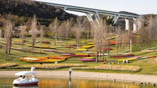
I explore the Awaji Strait National Government Park on Awaji Island. ...
I explore the Awaji Strait National Government Park on Awaji Island. It features gorgeous flower beds and landscaping, and lots of ...
Kobe & Awaji Island: A Seaside Adventure in Japan
Welcome to a journey exploring the beautiful seaside cities of Kobe ...
Welcome to a journey exploring the beautiful seaside cities of Kobe and Awaji Island in Japan! In this Vlog, enjoy the captivating ...
🇯🇵 A Day Trip To Awaji Island In Japan | Floating Staircase, Honpukuji Temple & Kozorasou Cafe
Another day of exploring the Kansai region! Just 1 hour drive away ...
Another day of exploring the Kansai region! Just 1 hour drive away from where we live in Osaka, we took a day trip to visit Awaji ...
How To Spend 1 Day on Awaji Island / 淡路島の1日遊び方
ワンちゃんと淡路島へ遊びに行きました!一日のロードトリップを一緒に楽しみましょう! We took our dog to Awaji ...
ワンちゃんと淡路島へ遊びに行きました!一日のロードトリップを一緒に楽しみましょう! We took our dog to Awaji Island for a ...
Let’s explore Awaji-shima! (Japan’s amazing island playground with hardly any foreign tourists)
Greetings from Awaji Island. Have you heard of this place? One of the ...
Greetings from Awaji Island. Have you heard of this place? One of the lesser-known areas of the country among foreign visitors, ...
Awaji Island Part II: NARUTO Park, Making Incense, Ancient Shrine & Local Food Adventure in Hyogo!
Welcome back to Awaji Island! ✨ In Part II, I dive deeper into this ...
Welcome back to Awaji Island! ✨ In Part II, I dive deeper into this amazing island in Hyogo Prefecture. From thrilling ...
【Japan travel guide】Awajishima island
Awaji shima island part 1, travel vlog day in my life in Japan
Awaji shima island part 1, travel vlog day in my life in Japan Part 2: ...
Awaji Island: Japan’s Secret Paradise You Must Visit #fyp #foryou #japantravel
Awaji Island's Roadside Gem! Epic Japanese Food Souvenirs & Regional Specialties! JAPAN😋
Get ready for a delicious detour! Join us on an exciting road trip in ...
Get ready for a delicious detour! Join us on an exciting road trip in Japan, as we hire a car in Kobe and make our way to Awaji ...
Japan's Famous Onion Island - Awajishima
In this video I ventured over to Hyogo Prefectures Awaji Island, just ...
In this video I ventured over to Hyogo Prefectures Awaji Island, just off the coast of Tokushima in Shikoku. There are lots of other ...
JAPAN | Awaji Island full day trip 🧅🐠
Japan Vlog Diaries #8! Awaji Shima / Island Full Day Trip with the ...
Japan Vlog Diaries #8! Awaji Shima / Island Full Day Trip with the fam. Awaji is a island in hyogo prefecture Japan. It's known for ...
Oh-SOBAR: Autumn soba course on Awaji Island, Japan
Take a look back with us at September's autumn-exclusive menu at ...
Take a look back with us at September's autumn-exclusive menu at Oh-SOBAR, a modern soba kappo restaurant on Awaji Island ...
🇯🇵 Why Does THIS Japanese Island Have The Best... Onions?? #shorts
Japan #foodie #japanesefood #Travel #Short #Shorts #Awaji #JapanTravel ...
Japan #foodie #japanesefood #Travel #Short #Shorts #Awaji #JapanTravel #JapanEats #RuralJapan #hiddengem #onion ...
Japan is classified as Developed region: G7: Group of Seven – Major advanced economies, including Canada, France, Germany, Italy, Japan, the United Kingdom, and the United States. The level of income is High income: OECD.
News – Latest Updates and Headlines from Awaji Shima
Stay informed with the most recent news and important headlines from Awaji Shima. Here’s a roundup of the latest developments.
Loading...
Please note: The data used here has been primarily extracted from satellite readings. Deviations from exact values may occur, particularly regarding the height of elevations and population density. Land area and coastline measurements refer to average values at mean high tide.