Baffin
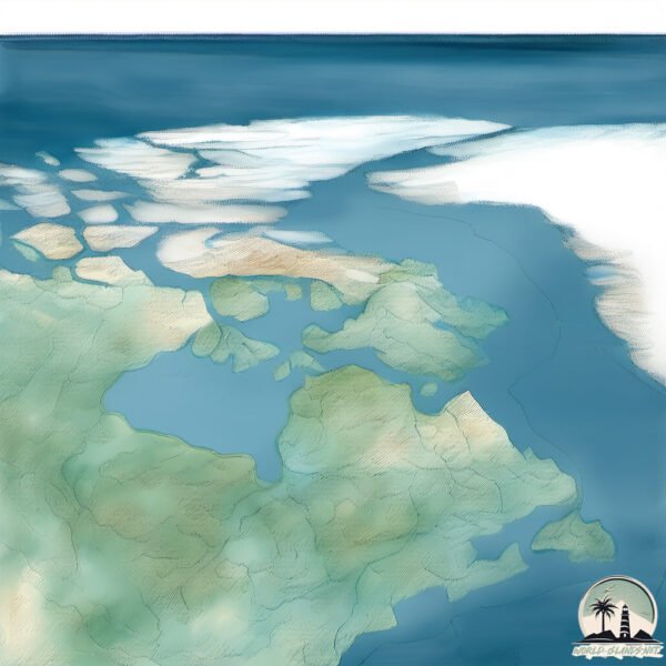
Welcome to Baffin, a Polar island in the The Northwestern Passages, part of the majestic Arctic Ocean. This guide offers a comprehensive overview of what makes Baffin unique – from its geography and climate to its population, infrastructure, and beyond. Dive into the details:
- Geography and Size: Explore the island’s size and location.
- Climate and Weather: Weather patterns and temperature.
- Topography and Nature: Uncover the natural wonders of the island.
- Infrastructure and Travelling: Insights on reaching, staying, and making the most of your visit.
- News and Headlines: Latest News.
Geography and size of Baffin
Size: 1.421 km²
Coastline: 8 km
Ocean: Arctic Ocean
Sea: The Northwestern Passages
Continent: North America
Baffin is a Small Island spanning 1.4 km² with a coastline of 8 km.
Archipel: Canadian Arctic Archipelago – A vast and remote region in northern Canada, consisting of a series of large and small islands known for their extreme Arctic environment and unique wildlife.
Tectonic Plate: North America – Covers North America and parts of the Atlantic and Arctic Oceans, characterized by diverse geological features and varying levels of seismic activity.
The geographic heart of the island is pinpointed at these coordinates:
Latitude: 68.60565533 / Longitude: -74.69159945
Climate and weather of Baffin
Climate Zone: Polar
Climate Details: Tundra
Temperature: Cold
Climate Characteristics: The tundra climate features long, extremely cold winters and short, cool summers. Vegetation is limited to mosses, lichens, and small shrubs due to the low temperatures and short growing seasons. Biodiversity is low, but some specialized species thrive.
Topography and nature of Baffin
Timezone: UTC-05:00
Timezone places: America/New_York
Max. Elevation: 2147 m Mt. Odin
Mean Elevation: 347 m
Vegetation: Sparse Vegetation
Tree Coverage: 15%
The mean elevation is 347 m. Dominating the island’s landscape, the majestic “Mt. Odin” rises as the highest peak, soaring to impressive heights. The island is characterized by Mountains: High, steeply elevated landforms. Characterized by both a high maximum elevation (over 500 meters) and a high mean elevation, creating rugged, mountainous terrains on islands.
Dominating Vegetation: Sparse Vegetation
These regions have limited plant growth, typically due to extreme conditions like aridity or poor soils. Vegetation is scattered and consists of hardy plant species. Baffin has a tree cover of 15 %.
Vegetation: 9 vegetation zones – Very Highly Diverse Island
Islands in this range are ecological powerhouses, showcasing a wide array of vegetation zones. Each zone, from lush rainforests to arid scrublands, coastal mangroves to mountainous regions, contributes to a complex and interdependent ecosystem. These islands are often hotspots of biodiversity, supporting numerous species and intricate ecological processes.
Infrastructure and Travelling to Baffin
Does the island have a public airport? yes.
Baffin has a public and scheduled airport. The following airports are located on this island: Arctic Bay Airport, Clyde River Airport, Iqaluit Airport, Pond Inlet Airport, Kimmirut Airport, Pangnirtung Airport.
Does the island have a major port? yes.
Baffin is home to a major port. The following ports are situated on the island: PANGNIRTUNG.
The mean population of Baffin is 0 per km². Baffin is Uninhabited. The island belongs to Canada.
The name of the island resonates across different cultures and languages. Here is how it is known around the world: Arabic: بافين; German: Baffininsel; Spanish: Isla de Baffin; French: Île de Baffin; Portuguese: Ilha de Baffin; Russian: Баффинова Земля; Chinese: 巴芬島
Continuing your journey, Kekertaluk Island is the next notable island, situated merely km away.
The Largest Island in Canada - Baffin Island

Canada is classified as Developed region: G7: Group of Seven – Major advanced economies, including Canada, France, Germany, Italy, Japan, the United Kingdom, and the United States. The level of income is High income: OECD.
News – Latest Updates and Headlines from Baffin
Stay informed with the most recent news and important headlines from Baffin. Here’s a roundup of the latest developments.
Please note: The data used here has been primarily extracted from satellite readings. Deviations from exact values may occur, particularly regarding the height of elevations and population density. Land area and coastline measurements refer to average values at mean high tide.