Welcome to Bali, a Tropical island in the Bali Sea, part of the majestic Pacific Ocean. This guide offers a comprehensive overview of what makes Bali unique – from its geography and climate to its population, infrastructure, and beyond. Dive into the details:
Geography and size of Bali
Size: 5413 km²
Coastline: 504 km
Ocean: Pacific Ocean
Sea: Bali Sea
Continent: Asia
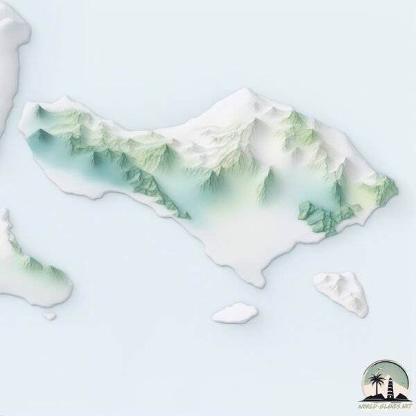
Bali is a Very Large Island spanning 5413 km² with a coastline of 504 km.
Archipel: Malay Archipelago – The world’s largest archipelago, located between mainland Southeast Asia and Australia, known for its immense biodiversity and cultural diversity.
Tectonic Plate: Sunda – Extends across Southeast Asia, encompassing parts of the Sunda Shelf, known for its interaction with the Australian Plate, contributing to volcanic activity in Indonesia.
The geographic heart of the island is pinpointed at these coordinates:
Latitude: -8.35466065 / Longitude: 115.11638622
Climate and weather of Bali
Climate Zone: Tropical
Climate Details: Tropical Monsoon Climate
Temperature: Hot
Climate Characteristics: Characterized by heavy rainfall, high humidity, and uniformly high temperatures, but with a distinct short dry season. It features a seasonal reversal of prevailing wind directions.
Topography and nature of Bali
Timezone: UTC+08:00
Timezone places: Australia/Perth
Max. Elevation: 3031 m Gunung Agung
Mean Elevation: 454 m
Vegetation: Evergreen Broadleaf Forest
Tree Coverage: 51%
The mean elevation is 454 m. Dominating the island’s landscape, the majestic “Gunung Agung” rises as the highest peak, soaring to impressive heights. The island is characterized by Mountains: High, steeply elevated landforms. Characterized by both a high maximum elevation (over 500 meters) and a high mean elevation, creating rugged, mountainous terrains on islands.
Dominating Vegetation: Evergreen Broadleaf Forest
Characterized by dense, lush canopies of broadleaf trees that retain their leaves year-round. These forests are typically found in tropical and subtropical regions and are known for their high biodiversity. Bali has a tree cover of 51 %.
Vegetation: 15 vegetation zones – Exceptionally Diverse Island
Islands with more than ten vegetation zones are among the most ecologically rich and varied in the world. These islands are akin to miniature continents, boasting an incredible array of ecosystems. The sheer range of habitats, from high peaks to deep valleys, rainforests to deserts, creates a mosaic of life that is unparalleled. They are crucial for conservation and ecological studies.
Infrastructure and Travelling to Bali
Does the island have a public airport? yes.
Bali has a public and scheduled airport. The following airports are located on this island: Letkol Wisnu Airstrip, Discovery Helipad, Ngurah Rai (Bali) International Airport.
Does the island have a major port? yes.
Bali is home to a major port. The following ports are situated on the island: .
The mean population of Bali is 879 per km². Bali is Densely Populated. The island belongs to Indonesia.
The name of the island resonates across different cultures and languages. Here is how it is known around the world: Arabic: بالي; German: Bali; Spanish: Bali; French: Bali; Portuguese: Bali; Russian: Бали; Chinese: 巴厘岛
Continuing your journey, Penida is the next notable island, situated merely km away.
Massive python swims through flooded streets in Bali
Popular tourist spots in Bali, Indonesia have been experiencing severe flash floods after a torrential rain hit the island on Feb 21.Massive python swims through flooded streets in Bali
Popular tourist spots in Bali, Indonesia have been experiencing severe ...
Popular tourist spots in Bali, Indonesia have been experiencing severe flash floods after a torrential rain hit the island on Feb 21.
Top 10 Most Beautiful Islands Near Bali - Travel Guide 2025
"Welcome to Travel Insights! Today, we're venturing beyond Bali's ...
"Welcome to Travel Insights! Today, we're venturing beyond Bali's shores to uncover the hidden gems of paradise—some of the ...
13 Best Places to Visit in Bali, Indonesia 🇮🇩
Best Places To Visit in Bali in 2026 - Travel Guide
Looking to travel to Bali in 2026? Look no further! This travel guide ...
Looking to travel to Bali in 2026? Look no further! This travel guide will give you all the necessary information to make the most of ...
The Real Bali Most People Miss | 4K Travel Documentary
This 4K travel documentary takes you beyond the typical tourist ...
This 4K travel documentary takes you beyond the typical tourist experience to uncover the real Bali most people miss. Explore ...
DON'T go HERE in BALI!! ❌ #bali #traveltips #indonesia #ubud #canggu #monkeys @Christian.Grossi
BALI: A Tropical Paradise | Full Travel Guide 2026 | Bali travel in 4k
Explore the tropical paradise of Bali in this full travel guide for ...
Explore the tropical paradise of Bali in this full travel guide for 2026! From stunning beaches to vibrant culture, this 4k Bali travel ...
BALI: Exploring One of the Most Enchanting Islands on Earth | 4K Travel Documentary
Bali is more than a destination — it's a feeling, a culture, and a way ...
Bali is more than a destination — it's a feeling, a culture, and a way of life. In this travel documentary, we explore the true beauty of ...
Is BALI Still Worth Traveling to?
Is Bali still the ultimate travel destination in 2026? Whether you're ...
Is Bali still the ultimate travel destination in 2026? Whether you're dreaming of a tropical escape, working remotely, or looking for ...
7 Days Bali Itinerary✨Check description for details 📌
Ready to escape to paradise? ✈️ Let us take care of your Bali plans! ...
Ready to escape to paradise? ✈️ Let us take care of your Bali plans! Our 7-Day guide is packed with must-see spots, hidden ...
First time surfing in Bali…. 😫 #surf #surfvlogger #balibeach #surfing #surfingvlog #baliisland
Best Time to Visit BALI 🇮🇩 | Travel Bali | Bali Videos | Bali Travel guide
10 Best Places to Visit in Bali l Must visit places in INDONESIA l #bali #indonesia #ubud #beach
This video series is all about Bali Tourist Places | Places to visit ...
This video series is all about Bali Tourist Places | Places to visit in Bali | Bali Tour | Bali Travel Guide | Bali Trip from India If you ...
Most Beautiful Places in Indonesia ✈️ 🌍 😱
Most Beautiful Places in Indonesia The Mentawai Islands - Paradise ...
Most Beautiful Places in Indonesia The Mentawai Islands - Paradise Lake Banggai Islands - Bali #shorts #nature #travel #explore ...
📍Bali,Indonesia🇲🇨 #travel#hotels#shorts#bali
REALITY OF BALI (NUSA PENIDA)🥲 Bali Guide 2025✨ Don’t go w/o watching THIS #travel #bali #shorts
BALI: most COMPLETE Travel Guide - ALL SIGHTS in 1 hour + NUSAS, KOMODO & GILIS - in 4K
Bali is the holiday paradise in Indonesia. Rice fields, temples, ...
Bali is the holiday paradise in Indonesia. Rice fields, temples, beautiful resort hotels, volcanoes and surf spots: Bali has it all.
Bali Swing - Indonesia | 10 Things to know before you visit Bali | read Description ❤️
The Bali Swing is the new tourism activity in Bali and it has become ...
The Bali Swing is the new tourism activity in Bali and it has become such a popular activity in Bali. . Bali Swing Pioneer, Jl. Dewi ...
Best street shopping in Bali with prices | Ubud art market | #shorts #travel #bali #indonesia
10 Must Visit Places in Bali | Bali places | Bali vlog | Bali best places to visit
Bali vs. Lombok: Which Island is Better?
Which island would you visit, if you have to pick one? I've spent ...
Which island would you visit, if you have to pick one? I've spent extensive time on both Bali and Lombok, as well as their ...
Bali, Indonesia The Most Famous Island in the World | Travel Video 8K
travel #8k #bali #balitravel #8kvideo #travelvideo8k #indonesia Bali, ...
travel #8k #bali #balitravel #8kvideo #travelvideo8k #indonesia Bali, Indonesia The Most Famous Island in the World - Travel ...
Bali or OTHER islands? My 3 suggestions from 3 months in Indonesia
Researching an Indonesia trip? I have a TON of resources for you BALI ...
Researching an Indonesia trip? I have a TON of resources for you BALI Check my itinerary for the interior and north, avoiding ...
HOW TO TRAVEL BALI - 14 Days in Paradise
This is how to travel Bali. The perfect 2 week Bali Indonesia ...
This is how to travel Bali. The perfect 2 week Bali Indonesia itinerary is right here for you to make sure you know what to do and ...
WHERE TO STAY IN BALI?? | BALI GUIDE 🌴 #bali #baliguide #baliindonesia #southeastasia
Indonesia is classified as Emerging region: MIKT: Mexico, Indonesia, South Korea, and Turkey – Economies recognized for their development potential and emerging market status. The level of income is Lower middle income.
News – Latest Updates and Headlines from Bali
Stay informed with the most recent news and important headlines from Bali. Here’s a roundup of the latest developments.
Loading...
Social Media Posts about Bali
Loading...
Please note: The data used here has been primarily extracted from satellite readings. Deviations from exact values may occur, particularly regarding the height of elevations and population density. Land area and coastline measurements refer to average values at mean high tide.