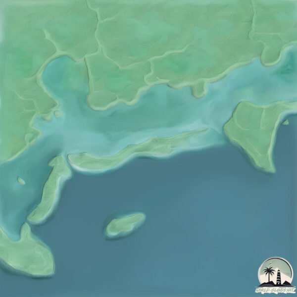
Welcome to Baraulu, a Tropical island in the Solomon Sea, part of the majestic Pacific Ocean. This guide offers a comprehensive overview of what makes Baraulu unique – from its geography and climate to its population, infrastructure, and beyond. Dive into the details:
Geography and size of Baraulu
Size: 5.315 km²
Coastline: 18.6 km
Ocean: Pacific Ocean
Sea: Solomon Sea
Continent: Oceania
Baraulu is a Small Island spanning 5.3 km² with a coastline of 18.6 km.
Archipel: Melanesia – A subregion of Oceania in the southwestern Pacific Ocean, including countries like Fiji, Solomon Islands, and Vanuatu, known for their diverse cultures and languages.
Tectonic Plate: Somalia – A large tectonic plate covering the Horn of Africa and parts of the Indian Ocean, known for the East African Rift where it’s splitting away from the African Plate.
The geographic heart of the island is pinpointed at these coordinates:
Latitude: -8.30682559 / Longitude: 157.38801981
Climate and weather of Baraulu
Climate Zone: Tropical
Climate Details: Tropical Rainforest Climate
Temperature: Hot
Climate Characteristics: This climate is typified by heavy rainfall throughout the year, high humidity, and consistently high temperatures, leading to lush rainforests and rich biodiversity. Seasonal temperature variations are minimal.
Topography and nature of Baraulu
Timezone: UTC+11:00
Timezone places: Pacific/Guadalcanal
Max. Elevation: 22 m
Mean Elevation: 13 m
Vegetation: Evergreen Broadleaf Forest
Tree Coverage: 97%
The mean elevation is 13 m. The highest elevation on the island reaches approximately 22 meters above sea level. The island is characterized by Plains: Flat, low-lying lands characterized by a maximum elevation of up to 200 meters. On islands, plains are typically coastal lowlands or central flat areas.
Dominating Vegetation: Evergreen Broadleaf Forest
Characterized by dense, lush canopies of broadleaf trees that retain their leaves year-round. These forests are typically found in tropical and subtropical regions and are known for their high biodiversity. Baraulu has a tree cover of 97 %.
Vegetation: 5 vegetation zones – Highly Diverse Island
With five different vegetation zones, these islands offer a rich tapestry of ecosystems. The variety could include dense forests, open meadows, wetlands, coastal zones, and more. This level of diversity supports an intricate web of life, with each zone playing a vital role in the overall ecological health and balance of the island.
Infrastructure and Travelling to Baraulu
Does the island have a public airport? no.
There is no public and scheduled airport on Baraulu. The nearest airport is Munda Airport, located 10 km away.
Does the island have a major port? no.
There are no major ports on Baraulu. The closest major port is PORT NORO, approximately 21 km away.
The mean population of Baraulu is 99 per km². Baraulu is Gently Populated. The island belongs to Solomon Islands.
Continuing your journey, Ndora is the next notable island, situated merely km away.
Safe disposal of WWII explosives in the Solomon Islands
Operation RENDER SAFE 2019 is a joint Australian and New Zealand Defence Force effort working with the Royal Solomon ...Safe disposal of WWII explosives in the Solomon Islands
Operation RENDER SAFE 2019 is a joint Australian and New Zealand ...
Operation RENDER SAFE 2019 is a joint Australian and New Zealand Defence Force effort working with the Royal Solomon ...
Discover Solomon Islands Paradise in 2024 #solomon #island #travel
512K subscriber.
512K subscriber.
Drone shot of islands in Roviana lagoon at sunset, Munda. Solomon Islands, Pacific Ocean.
Drone shot of islands in Roviana lagoon at sunset, Munda. Western ...
Drone shot of islands in Roviana lagoon at sunset, Munda. Western Province, Solomon Islands, Pacific Ocean. © Tom Vierus ...
goalpost dance, Hamba, Rendova Island, W Solomon Island
soccer spectator entertains.
soccer spectator entertains.
【K】Solomon Islands Travel-Guadalcanal Island[솔로몬제도 여행-뉴조지아]스쿠버다이빙, 열대어와 전쟁잔해/Scuba Diving
KBS 걸어서 세계속으로 PD들이 직접 만든 해외여행전문 유투브 채널 【Everywhere, K】 □ The Travels ...
KBS 걸어서 세계속으로 PD들이 직접 만든 해외여행전문 유투브 채널 【Everywhere, K】 □ The Travels of Nearly Everywhere!
Exploring a cave on Ndora Island in the Roviana Lagoon 🇸🇧 #caveexploration #batcave #solomonislands
Solomon Island
New Georgia Island February 1994 8°28'10.78"S 157°53'36.51"E.
New Georgia Island February 1994 8°28'10.78"S 157°53'36.51"E.
The U.S. Navy’s Ambush at Kula Gulf, 1943 - Animated
In the dead of night on July 6, 1943, U.S. and Japanese warships ...
In the dead of night on July 6, 1943, U.S. and Japanese warships collided in the narrow waters of the Solomon Islands. American ...
Marovo Lagoon in Marovo, Solomon Islands
Marovo Lagoon is the largest saltwater lagoon in the World. Located in ...
Marovo Lagoon is the largest saltwater lagoon in the World. Located in the New Georgia Islands, surrounded by Vangunu Island ...
Solomon Islands: Roviana Lagoon Day Trip
We organised the Hopei Island day trip. In the morning went to a river ...
We organised the Hopei Island day trip. In the morning went to a river and went looking for saltwater crocodiles. For lunch we went ...
Explore Roviana Lagoon | Freedom Adventures & Solomon Airlines
Join Freedom Adventures in partnership with Solomon Airlines as we ...
Join Freedom Adventures in partnership with Solomon Airlines as we explore the stunning Roviana Lagoon in the Solomon ...
AFTERMATH OF TWO F4U'S MIDAIR CRASH, VELLA LAVELLA FLD., NEW GEORGIA ISLAND
Date: ca. 1947 - 1980 Creators: Department of Defense. Department of ...
Date: ca. 1947 - 1980 Creators: Department of Defense. Department of the Navy. Naval Photographic Center. 9/18/1947- ?
2007 Solomon Islands Field School (Documentary)
In 2007, Jonathan Barron was awarded a travel grant from the Fund for ...
In 2007, Jonathan Barron was awarded a travel grant from the Fund for Teachers, to teach a Field School Program in Coral Reef ...
welcome to Marovo SeaLodge
Marovo SeaLodge is located in Chuchulu village ,eastern shoreline of ...
Marovo SeaLodge is located in Chuchulu village ,eastern shoreline of New Georgia Marovo lagoon western province Solomon ...
World War II: Kula Gulf
World War II: The Battle of Kula Gulf** The Battle of Kula Gulf, ...
World War II: The Battle of Kula Gulf** The Battle of Kula Gulf, fought on the night of July 6, 1943, was a critical naval engagement ...
Solomon Islands welcome video
Nusa Roviana.
Nusa Roviana.
Weekend String Band Show Episode 1
This episode features the Swing to the Strings - Nusa Roviana Bamboo ...
This episode features the Swing to the Strings - Nusa Roviana Bamboo Band courtesy of SIBC TV Live Stream on July 5, 2019.
FIELD TRIP WITH PATRICK BLANC IN SOLOMON ISLANDS - GHIZO, KOLOMBANGARA & NEW GEORGIA
The botanist Patrick Blanc, inventor of the Vertical Garden (Mur ...
The botanist Patrick Blanc, inventor of the Vertical Garden (Mur Végétal) takes you to a Field Trip in Solomon Islands - Part 2 ...
🇸🇧களத்துல இறங்கி அடிச்சிருக்கோம்👍| South Pacific | Solomon Islands EP5
Season 9 begins and it is much expected South Pacific. In this ...
Season 9 begins and it is much expected South Pacific. In this episode, explored the deepest village in Pacific located in New ...
Paradise Village, Western Province of the Solomon Islands. #solomonislands
Paradise Village, North New Georgia. Western Province of the Solomon ...
Paradise Village, North New Georgia. Western Province of the Solomon Islands. Filmed by Studiohomegrown Productions.
HOLIDAY TRIP IN RANONGA ISLAND, SOLOMON ISLANDS
Ranongga is an island located in the New Georgia Islands group of ...
Ranongga is an island located in the New Georgia Islands group of Western Province, Solomon Islands. Ranongga is a long and ...
Visiting Ghizo Island, Island in the Solomon Islands
Ghizo Island, home to Gizo, the capital of the Western Province, ...
Ghizo Island, home to Gizo, the capital of the Western Province, Solomon Islands. The island is named after an infamous local ...
Battle of Kolombangara (1943): The Night the Cruisers Collided
This video tells the story of the Battle of Kolombangara, a fierce ...
This video tells the story of the Battle of Kolombangara, a fierce night clash in the Solomons in July 1943. Allied cruisers and ...
【K】Solomon Islands Travel-Guadalcanal Island[솔로몬제도 여행-뉴조지아]기조섬의 투명한 바다/Ghizo Island/Sea/Coral/Nature
KBS 걸어서 세계속으로 PD들이 직접 만든 해외여행전문 유투브 채널 【Everywhere, K】 □ The Travels ...
KBS 걸어서 세계속으로 PD들이 직접 만든 해외여행전문 유투브 채널 【Everywhere, K】 □ The Travels of Nearly Everywhere!
Holiday in Roviana Lagoon, Solomon Islands.
The tropical Islands and waters of solomon Islands is one of the best ...
The tropical Islands and waters of solomon Islands is one of the best in the pacific. Nice place to take time out and relax.
Solomon Islands is classified as Least developed region: Countries that exhibit the lowest indicators of socioeconomic development, with the lowest Human Development Index ratings. The level of income is Lower middle income.
News – Latest Updates and Headlines from Baraulu
Stay informed with the most recent news and important headlines from Baraulu. Here’s a roundup of the latest developments.
Loading...
Please note: The data used here has been primarily extracted from satellite readings. Deviations from exact values may occur, particularly regarding the height of elevations and population density. Land area and coastline measurements refer to average values at mean high tide.


![【K】Solomon Islands Travel-Guadalcanal Island[솔로몬제도 여행-뉴조지아]스쿠버다이빙, 열대어와 전쟁잔해/Scuba Diving](https://i.ytimg.com/vi/B09SX-NF_wk/mqdefault.jpg)


![【K】Solomon Islands Travel-Guadalcanal Island[솔로몬제도 여행-뉴조지아]기조섬의 투명한 바다/Ghizo Island/Sea/Coral/Nature](https://i.ytimg.com/vi/pPppN63WYYM/mqdefault.jpg)
