Barba Negra
Welcome to Barba Negra, a Temperate island in the South Atlantic Ocean, part of the majestic Atlantic Ocean. This guide offers a comprehensive overview of what makes Barba Negra unique – from its geography and climate to its population, infrastructure, and beyond. Dive into the details:
- Geography and Size: Explore the island’s size and location.
- Climate and Weather: Weather patterns and temperature.
- Topography and Nature: Uncover the natural wonders of the island.
- Infrastructure and Travelling: Insights on reaching, staying, and making the most of your visit.
- News and Headlines: Latest News.
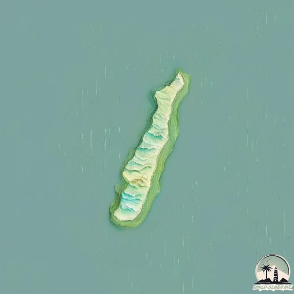
Geography and size of Barba Negra
Size: 1.51 km²
Coastline: 8.2 km
Ocean: Atlantic Ocean
Sea: South Atlantic Ocean
Continent: South America
Barba Negra is a Small Island spanning 1.5 km² with a coastline of 8.2 km.
Archipel: –
Tectonic Plate: South America – A major plate covering the South American continent and part of the Atlantic Ocean, known for the Andes mountain range and significant seismic and volcanic activity.
The geographic heart of the island is pinpointed at these coordinates:
Latitude: -30.48630615 / Longitude: -51.15043487
Climate and weather of Barba Negra
Climate Zone: Temperate
Climate Details: Humid Subtropical Climate
Temperature: Hot Summer
Climate Characteristics: With continuous rainfall and hot summers, this climate is common in some coastal regions, supporting diverse vegetation.
Topography and nature of Barba Negra
Timezone: UTC-03:00
Timezone places: America/Sao_Paulo
Max. Elevation: 3 m
Mean Elevation: 2 m
Vegetation: Shrubland
Tree Coverage: 86%
The mean elevation is 2 m. The highest elevation on the island reaches approximately 3 meters above sea level. The island is characterized by Plains: Flat, low-lying lands characterized by a maximum elevation of up to 200 meters. On islands, plains are typically coastal lowlands or central flat areas.
Dominating Vegetation: Shrubland
Dominated by shrubs and small bushes, these areas are typical in dry, rocky, or sandy environments, as well as in regions with poor soil fertility. Barba Negra has a tree cover of 86 %.
Vegetation: 4 vegetation zones – Diverse Island
Four distinct vegetation zones mark these islands as ecologically diverse. They might feature varied landscapes such as forests, beaches, grasslands, and rocky areas. Such diversity reflects the island’s complex ecological interactions and varied habitats, which can support a rich array of wildlife and plant species.
Infrastructure and Travelling to Barba Negra
Does the island have a public airport? no.
There is no public and scheduled airport on Barba Negra. The nearest airport is Salgado Filho International Airport, located 53 km away.
Does the island have a major port? no.
There are no major ports on Barba Negra. The closest major port is PORTO ALEGRE, approximately 49 km away.
The mean population of Barba Negra is 0 per km². Barba Negra is Uninhabited. The island belongs to Brazil.
Continuing your journey, Ilha dos Marinheiros is the next notable island, situated merely km away.
Veleiro Barba Negra #87 - Clifton, Happy Island e Union Island


Brazil is classified as Emerging region: BRIC: Brazil, Russia, India, and China – Economies noted for their rapid growth and increasing influence on global affairs. The level of income is Upper middle income.
News – Latest Updates and Headlines from Barba Negra
Stay informed with the most recent news and important headlines from Barba Negra. Here’s a roundup of the latest developments.
Please note: The data used here has been primarily extracted from satellite readings. Deviations from exact values may occur, particularly regarding the height of elevations and population density. Land area and coastline measurements refer to average values at mean high tide.