Welcome to Barbados, a Tropical island in the Caribbean Sea, part of the majestic Atlantic Ocean. This guide offers a comprehensive overview of what makes Barbados unique – from its geography and climate to its population, infrastructure, and beyond. Dive into the details:
Geography and size of Barbados
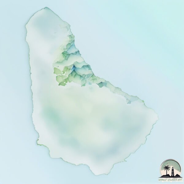
Size: 435.1 km²
Coastline: 104.9 km
Ocean: Atlantic Ocean
Sea: Caribbean Sea
Continent: North America
Barbados is a Large Island spanning 435 km² with a coastline of 105 km.
Archipel: Lesser Antilles – A long arc of small islands in the Caribbean Sea, stretching from the Virgin Islands to Trinidad, known for their distinct cultures and tropical landscapes.
Tectonic Plate: Caribbean – Covering the Caribbean Sea and surrounding regions, this plate is bordered by the North American Plate and the South American Plate. Known for seismic activity, including earthquakes and volcanic eruptions, and features like the Puerto Rico Trench.
The geographic heart of the island is pinpointed at these coordinates:
Latitude: 13.17245216 / Longitude: -59.55658301
Climate and weather of Barbados
Climate Zone: Tropical
Climate Details: Tropical Monsoon Climate
Temperature: Hot
Climate Characteristics: Characterized by heavy rainfall, high humidity, and uniformly high temperatures, but with a distinct short dry season. It features a seasonal reversal of prevailing wind directions.
Topography and nature of Barbados
Timezone: UTC-04:00
Timezone places: America/La_Paz
Max. Elevation: 314 m
Mean Elevation: 106 m
Vegetation: Cultivated Land
Tree Coverage: 21%
The mean elevation is 106 m. The highest elevation on the island reaches approximately 314 meters above sea level. The island is characterized by Hills: Gently sloping landforms with rounded tops, having a maximum elevation between 200 and 500 meters. Hills contribute to a varied landscape on islands.
Dominating Vegetation: Cultivated Land
Areas dedicated to agricultural activities, growing crops like grains, vegetables, and fruits. These lands are usually human-modified landscapes. Barbados has a tree cover of 21 %.
Vegetation: 13 vegetation zones – Exceptionally Diverse Island
Islands with more than ten vegetation zones are among the most ecologically rich and varied in the world. These islands are akin to miniature continents, boasting an incredible array of ecosystems. The sheer range of habitats, from high peaks to deep valleys, rainforests to deserts, creates a mosaic of life that is unparalleled. They are crucial for conservation and ecological studies.
Infrastructure and Travelling to Barbados
Does the island have a public airport? yes.
Barbados has a public and scheduled airport. The following airports are located on this island: Grantley Adams International Airport.
Does the island have a major port? yes.
Barbados is home to a major port. The following ports are situated on the island: .
The mean population of Barbados is 659 per km². Barbados is Densely Populated. The island belongs to Barbados.
Continuing your journey, St. Lucia is the next notable island, situated merely km away.
BARBADOS Travel Guide 2026 - 10 Best Things To Do
https://expluxtravel.com/itinerary ⬅️ Order the custom travel itinerary here 10 Best Things To Do in Barbados 0:00 Barbados ...BARBADOS Travel Guide 2026 - 10 Best Things To Do
Top 10 Places to Visit in Barbados | Top Barbados Attractions
Enjoy this hand picked places to visit in Barbados AirHelp✈️ is a ...
Enjoy this hand picked places to visit in Barbados AirHelp✈️ is a revolutionary new way to get your flight compensation claims ...
Barbados Travel Guide: 13 Things to Do in Barbados (& Things to Do)
How to find cheap flights and travel more: ...
Best Things To Do in Barbados 4K
BARBADOS: In this list of the best things to do in Barbados, we show ...
BARBADOS: In this list of the best things to do in Barbados, we show you around the top attractions in Barbados. If you plan to visit ...
IMPORTANT Barbados Travel Tips (Things You Should Not Do)
barbados #travelguide #tourism #traveltips.
barbados #travelguide #tourism #traveltips.
BARBADOS: The MOST Relaxed Island of the CARIBBEAN! Travel Guide to ALL SIGHTS
THIS is the place for a holiday. We are cruising the Caribbean, ...
THIS is the place for a holiday. We are cruising the Caribbean, passing all sorts of tropical islands. Some have nature, some have ...
10 MIND-BLOWING FACTS About BARBADOS - The Most UNIQUE ISLAND of the CARIBBEANS - Travel Documentary
10 MIND-BLOWING FACTS About BARBADOS - The Most UNIQUE ISLAND of the ...
10 MIND-BLOWING FACTS About BARBADOS - The Most UNIQUE ISLAND of the CARIBBEANS - Travel Documentary ...
50 SHOCKING Geography Facts About Barbados You Never Knew
PREPARE TO BE AMAZED! Discover 50 mind-blowing secrets about Barbados ...
PREPARE TO BE AMAZED! Discover 50 mind-blowing secrets about Barbados that will completely change how you see this ...
17 IMPORTANT TIPS to know before traveling to BARBADOS
What every traveler should know before planning a trip to beautiful ...
What every traveler should know before planning a trip to beautiful Barbados. Travel guide containing 17 tips to help you explore, ...
Barbados 🇧🇧📍#barbados #caribbeanisland #beautifulbarbados #caribbean #islands #islandhopping
BARBADOS TRAVEL TIPS - 15 Things You Need to Know BEFORE You Go to Barbados
If you are planning your first trip to Barbados, these are all the ...
If you are planning your first trip to Barbados, these are all the things you need to know before you go! We'll cover the currency, ...
Top places to visit in Barbados ✨🇧🇧 Broad Street in Bridgetown for Shopping ✨ #barbados #travel
Barbados Island Guide
Catherine Leech takes us on one of her signature Caribbean island ...
Catherine Leech takes us on one of her signature Caribbean island tours, this time to the Barbados!
Barbados 🇧🇧 to Bermuda 🇧🇲
Barbados Hidden Geography EXPOSED by a Local Bajan
Barbados Hidden Geography EXPOSED by a Local Bajan” Discover the ...
Barbados Hidden Geography EXPOSED by a Local Bajan” Discover the shocking truth behind Barbados' hidden landscapes, ...
FIRST TIME IN BARBADOS! 🇧🇧 SO BEAUTIFUL
Take back your personal data with Incogni! Use code JUMPINGPLACES at ...
Take back your personal data with Incogni! Use code JUMPINGPLACES at the link below and get 60% off an annual plan: ...
Barbados vs Bahamas, Which Country Is Better?
Barbados and the Bahamas are both stunning island nations located in ...
Barbados and the Bahamas are both stunning island nations located in the Caribbean region, known for their breathtaking ...
History of Barbados: The Island Blueprint That Shaped the New World
Discover the full untold history of Barbados — from the ancient Arawak ...
Discover the full untold history of Barbados — from the ancient Arawak and Kalinago settlers to the rise of the sugar empire, the ...
Barbados ISLAND FACTS YOU MAY NOT KNOW
Barbados, West Indies. Please like, share, and subscribe to my videos. ...
Barbados, West Indies. Please like, share, and subscribe to my videos. Thank you. You can view my videos @worlddashers This ...
What You'll See on a Six-Hour Tour of Barbados
Adventure begins where the paved road ends... Music: "Fire On The ...
Adventure begins where the paved road ends... Music: "Fire On The Horizon" - Stick Figure "Edge of the Ocean" - Stick Figure.
Barbados Geography 🇧🇧 #15
This is day 15 of exploring 195 countries in 195 days. Today we are ...
This is day 15 of exploring 195 countries in 195 days. Today we are heading to the Caribbean. Barbados is an island country ...
First Day In Barbados, A Walk Through Bridgetown In Less Than 24 Hours
History was made and History will continue to be made as we Visited ...
History was made and History will continue to be made as we Visited the Blue seas island called Barbados by kind courtesy of ...
Barbados top attractions #barbados #beach #caribbean #travelvlog #travel #bucketlist #vacation
Experience the BEST of BARBADOS 2025 in Just 4 Days!
Ready to plan a quick girls' trip getaway to Barbados? ☀️ Join us as ...
Ready to plan a quick girls' trip getaway to Barbados? ☀️ Join us as we explore the island in 4 amazing days!
How to spend $100 in Barbados #shorts
In this video we visit barbados, bridgetown with virgin atlantic from ...
In this video we visit barbados, bridgetown with virgin atlantic from manchester airport. Join us on an exciting adventure in the ...
Barbados is classified as Developing region: Regions characterized by lower income levels, with economies in the process of industrialization and modernization. The level of income is High income: nonOECD.
News – Latest Updates and Headlines from Barbados
Stay informed with the most recent news and important headlines from Barbados. Here’s a roundup of the latest developments.
Loading...
Please note: The data used here has been primarily extracted from satellite readings. Deviations from exact values may occur, particularly regarding the height of elevations and population density. Land area and coastline measurements refer to average values at mean high tide.