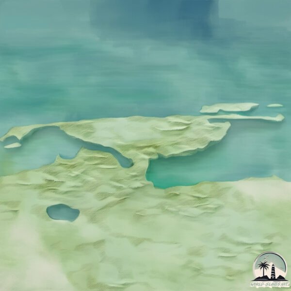
Welcome to Barter, a Polar island in the Beaufort Sea, part of the majestic Arctic Ocean. This guide offers a comprehensive overview of what makes Barter unique – from its geography and climate to its population, infrastructure, and beyond. Dive into the details:
Geography and size of Barter
Size: 14.8 km²
Coastline: 40.1 km
Ocean: Arctic Ocean
Sea: Beaufort Sea
Continent: North America
Barter is a Medium Island spanning 15 km² with a coastline of 40 km.
Archipel: –
Tectonic Plate: North America – Covers North America and parts of the Atlantic and Arctic Oceans, characterized by diverse geological features and varying levels of seismic activity.
The geographic heart of the island is pinpointed at these coordinates:
Latitude: 70.11813115 / Longitude: -143.66344561
Climate and weather of Barter
Climate Zone: Polar
Climate Details: Tundra
Temperature: Cold
Climate Characteristics: The tundra climate features long, extremely cold winters and short, cool summers. Vegetation is limited to mosses, lichens, and small shrubs due to the low temperatures and short growing seasons. Biodiversity is low, but some specialized species thrive.
Topography and nature of Barter
Timezone: UTC-09:00
Timezone places: America/Anchorage
Max. Elevation: 14 m
Mean Elevation: 6 m
Vegetation: Herbaceous Cover
Tree Coverage: 23%
The mean elevation is 6 m. The highest elevation on the island reaches approximately 14 meters above sea level. The island is characterized by Plains: Flat, low-lying lands characterized by a maximum elevation of up to 200 meters. On islands, plains are typically coastal lowlands or central flat areas.
Dominating Vegetation: Herbaceous Cover
Comprising mainly of grasses, herbs, and ferns, these areas are common in prairies, meadows, and savannas, and can vary widely in species composition. Barter has a tree cover of 23 %.
Vegetation: 6 vegetation zones – Very Highly Diverse Island
Islands in this range are ecological powerhouses, showcasing a wide array of vegetation zones. Each zone, from lush rainforests to arid scrublands, coastal mangroves to mountainous regions, contributes to a complex and interdependent ecosystem. These islands are often hotspots of biodiversity, supporting numerous species and intricate ecological processes.
Infrastructure and Travelling to Barter
Does the island have a public airport? no.
There is no public and scheduled airport on Barter. The nearest airport is Arctic Village Airport, located 303 km away.
Does the island have a major port? yes.
Barter is home to a major port. The following ports are situated on the island: BERNARD HARBOR.
The mean population of Barter is 21 per km². Barter is Gently Populated. The island belongs to United States of America.
Continuing your journey, Foggy is the next notable island, situated merely km away.
Flying over Barter on a NICE day!
Flying over Kaktovik!Flying over Barter on a NICE day!
Flying over Kaktovik!
Flying over Kaktovik!
C-208 Departing Barter Island (PABA) - Wright Air Service
During the COVID 2020 Pandemic I took a company paid leave from the ...
During the COVID 2020 Pandemic I took a company paid leave from the airlines. Returned home to Alaska flying the fun stuff!
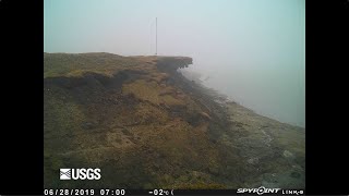
Time-lapse video of bluff erosion on Barter Island, Alaska
Recorded June 1, 2019 - August 18, 2019 Video shows a series of photos ...
Recorded June 1, 2019 - August 18, 2019 Video shows a series of photos taken every hour during daylight hours in the summer ...
Polar bears descend on Alaskan village, causing tourist boom: Part 1
Visitors flock to Kaktovik, Alaska, to see the bears, who are ...
Visitors flock to Kaktovik, Alaska, to see the bears, who are wandering into town because experts say the sea ice they need is ...
Barter Island, Alaska- Erosion TIMELAPSE | Climate Change in Alaska
Recommended Resources Climate Change: What Everyone Needs to Know ...
Recommended Resources Climate Change: What Everyone Needs to Know
http://amzn.to/2nUOAjP This Changes Everything: ...
Unknown But True: The Barter Islands Mystery
A concise history dive into a forgotten Arctic mystery, uncovering ...
A concise history dive into a forgotten Arctic mystery, uncovering facts behind a puzzling event. #ArcticHistory #CulturalExchange ...
BEAUTIFUL Barter By the Beaufort Inflight!
Flying over Kaktovik!
Flying over Kaktovik!
Barter Island
Just another day on the slope.
Just another day on the slope.
Afternoon flight over Kaktovik!
Flying over Barter!
Flying over Barter!
Barter Island, Alaska where polar bear outnumber the people
A month in the life of yours truly.
A month in the life of yours truly.
Kaktovik | Best Places in Kaktovik Alaska | Kaktovik Alaska
Kaktovik Alaska is one of the most remote and fascinating places in ...
Kaktovik Alaska is one of the most remote and fascinating places in the United States, located on Barter Island along the Arctic ...
Barter's Island drawbridge is now open after facing numerous challenges
Residents celebrated the grand opening of the bridge after it had been ...
Residents celebrated the grand opening of the bridge after it had been under construction for 21 months.
Barter Island
Just another day of Art doing his job filming the bears.
Just another day of Art doing his job filming the bears.
'Captain Dick "Them's my toes" Barter' Island (not one of the many names this island has had)
This small blob of granite sits alone in the pristine blue water of ...
This small blob of granite sits alone in the pristine blue water of Lake Tahoe and has been capturing the attention of island-gazers ...
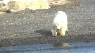
Polar bear and cubs in Barter Island, Alaska
Polar Bears at Barter Island
Getting close to some polar bears while TDY at Barter Island.
Getting close to some polar bears while TDY at Barter Island.
Polar ice pack Aug. 1988 Barter Island Alaska taken from CH-3 Helicopter
This is an old home video, taken in Aug. 1988, just north of Barter ...
This is an old home video, taken in Aug. 1988, just north of Barter Island which is near Kaktovic on the north slope of Alaska. Enjoy ...
working in Kaktovic Alaska
Barter Island
Polar bears feeding on a whale carcass at Barter Island, Alaska.
Polar bears feeding on a whale carcass at Barter Island, Alaska.
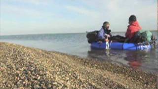
Barter Island Packraft Landing.mov
Landing on Barter Island in the Arctic after crossing Arey Lagoon. ...
Landing on Barter Island in the Arctic after crossing Arey Lagoon. During the summer of 2010 we traversed the Arctic National ...
JoLo World Vlog 8: ALASKA 4B! Extreme North (Kaktovik, polar bears, Barter Island, Northern Lights)
We expected two days of being on a boat in the icy cold wind, watching ...
We expected two days of being on a boat in the icy cold wind, watching polar bears. The first afternoon went as planned.
Huge polarbear in arctic circle #polarbear #lynx #reindeer
Polar bear Temporal range: Pleistocene-recent[1] Polar Bear - Alaska ...
Polar bear Temporal range: Pleistocene-recent[1] Polar Bear - Alaska (cropped).jpg Sow near Kaktovik, Barter Island, Alaska, ...
Barter Island Polar Bears
Momma and her two cubs. Filmed from the back of a small boat in the ...
Momma and her two cubs. Filmed from the back of a small boat in the Artic Ocean. The white blur going by is the mast of the boat ...
Barter Island
8mm reel from the archive.
8mm reel from the archive.
United States of America is classified as Developed region: G7: Group of Seven – Major advanced economies, including Canada, France, Germany, Italy, Japan, the United Kingdom, and the United States. The level of income is High income: OECD.
News – Latest Updates and Headlines from Barter
Stay informed with the most recent news and important headlines from Barter. Here’s a roundup of the latest developments.
Loading...
Please note: The data used here has been primarily extracted from satellite readings. Deviations from exact values may occur, particularly regarding the height of elevations and population density. Land area and coastline measurements refer to average values at mean high tide.