Welcome to Beijian Dao, a Temperate island in the South China Sea, part of the majestic Pacific Ocean. This guide offers a comprehensive overview of what makes Beijian Dao unique – from its geography and climate to its population, infrastructure, and beyond. Dive into the details:
Geography and size of Beijian Dao
Size: 3.549 km²
Coastline: 15 km
Ocean: Pacific Ocean
Sea: South China Sea
Continent: Asia
Beijian Dao is a Small Island spanning 3.5 km² with a coastline of 15 km.
Archipel: –
Tectonic Plate: Yangtze – A minor tectonic plate in East Asia, often considered a part of the Eurasian Plate. It’s primarily continental and covers the Yangtze River area in China, playing a significant role in the region’s geological stability.
The geographic heart of the island is pinpointed at these coordinates:
Latitude: 21.89676502 / Longitude: 114.0488135
Climate and weather of Beijian Dao
Climate Zone: Temperate
Climate Details: Monsoon-Influenced Humid Subtropical Climate
Temperature: Hot Summer
Climate Characteristics: Known for hot, humid summers with significant monsoon rains, contrasted by mild, drier winters.
Topography and nature of Beijian Dao
Timezone: UTC+08:00
Timezone places: Australia/Perth
Max. Elevation: 76 m
Mean Elevation: 42 m
Vegetation: Sparse Vegetation
Tree Coverage: 42%
The mean elevation is 42 m. The highest elevation on the island reaches approximately 76 meters above sea level. The island is characterized by Plains: Flat, low-lying lands characterized by a maximum elevation of up to 200 meters. On islands, plains are typically coastal lowlands or central flat areas.
Dominating Vegetation: Sparse Vegetation
These regions have limited plant growth, typically due to extreme conditions like aridity or poor soils. Vegetation is scattered and consists of hardy plant species. Beijian Dao has a tree cover of 42 %.
Vegetation: 8 vegetation zones – Very Highly Diverse Island
Islands in this range are ecological powerhouses, showcasing a wide array of vegetation zones. Each zone, from lush rainforests to arid scrublands, coastal mangroves to mountainous regions, contributes to a complex and interdependent ecosystem. These islands are often hotspots of biodiversity, supporting numerous species and intricate ecological processes.
Infrastructure and Travelling to Beijian Dao
Does the island have a public airport? no.
There is no public and scheduled airport on Beijian Dao. The nearest airport is Shun Tak Heliport, located 43 km away.
Does the island have a major port? no.
There are no major ports on Beijian Dao. The closest major port is HONG KONG, approximately 42 km away.
The mean population of Beijian Dao is 66 per km². Beijian Dao is Gently Populated. The island belongs to China.
Continuing your journey, Dangan Dao is the next notable island, situated merely km away.
This Chinese Island Holds the Secrets to Beijing’s Massive Naval Expansion | WSJ Coordinates
China is expanding its naval bases on the tropical island of Hainan in the South China Sea. Two of Beijing's most important naval ...This Chinese Island Holds the Secrets to Beijing’s Massive Naval Expansion | WSJ Coordinates
China is expanding its naval bases on the tropical island of Hainan in ...
China is expanding its naval bases on the tropical island of Hainan in the South China Sea. Two of Beijing's most important naval ...
🇨🇳|Shamian Island, Guangzhou...#guangzhou #china #shanghai #beijing #singapore #shamianisland
10 Interesting Places to Visit in Guangzhou 广州; Beijing Road, Shamian Island, Bruce Lee’s House
Hi everyone, welcome to Gibbon Travelogue! In this video, we'll take ...
Hi everyone, welcome to Gibbon Travelogue! In this video, we'll take you on a journey through Guangzhou, exploring 10 ...
4 Days Exploring around Guangzhou China: Cantonese food, Foshan Day Trip, Must-Visit Attractions
In this video, we went to Guangzhou for a short vacation in March. We ...
In this video, we went to Guangzhou for a short vacation in March. We visited famous places in Guangzhou including Beijing Road ...
Minecraft Bridging Methods - Andromeda 💀 #minecraft #dragclick
Learn the best bridging methods in Minecraft with Andromeda! From ...
Learn the best bridging methods in Minecraft with Andromeda! From speedtelly to godbridge, this tutorial covers all the techniques ...
Why is Manila strengthening illegal occupation of Zhongye Dao?
Zhongye Dao is an important part of the Nansha Qundao group in the ...
Zhongye Dao is an important part of the Nansha Qundao group in the #SouthChinaSea. #China claims indisputable sovereignty ...
Beautiful Kicking skills From Black Belt Taekwondo Girl ! #tkdgirl #martialartist #blackbelt #fyp
China attests Taiping Dao is “island, not a rock”
China has reiterated its sovereignty over the Nansha Islands and ...
China has reiterated its sovereignty over the Nansha Islands and adjacent waters in the South China Sea, including the largest of ...
Sweet and Sour Pork Ribs Recipe #foodie #chineserecipe #chinesefood #porkribs
Things to do in Guangzhou China 🇨🇳 Visit Shamian Island #guangzhou #shamianisland #travel
Inside China’s Massive Apartment Complex with 30,000 Residents!
Join me as I take you on an exclusive tour of Regent International ...
Join me as I take you on an exclusive tour of Regent International Apartments located in the heart of Qianjiang Century City, ...
Kung Fu Monk Performing |Shaolin Kung Fu
...
5 Must-Visit Places in Guangzhou, China 🇨🇳✨ Travelwithlocals#chinatravel #guangzhou #travel
Tour Of Shamian Island - Guangzhou, China 🇨🇳
shamian #shamianisland #guangzhouvlog Shamian (also romanized as ...
shamian #shamianisland #guangzhouvlog Shamian (also romanized as Shameen or Shamin, both from its Cantonese ...
Beijing: Diaoyu Islands Chinese Territory | Indus News | Indus News Bulletin
China said the #DiaoyuIslands are its territory and it reserves the ...
China said the #DiaoyuIslands are its territory and it reserves the right to conduct law enforcement activities in the area. #China ...
Walking to Ye Li Dao Island Zhuhai Guangdong China July 2013
Only natural that Diaoyu Dao and its affiliated islands are marked as Chinese territory on a map
AFP: Japan's Chief Cabinet Secretary Hirokazu Matsuno has criticized ...
AFP: Japan's Chief Cabinet Secretary Hirokazu Matsuno has criticized the release of a Chinese government map that shows what ...
EPIC Walking Tour Guangzhou China 2026 🇨🇳 4K | Canton Tower, Beijing Road, Shamian & Pearl River
Discover the vibrant metropolis of Guangzhou, China, exploring iconic ...
Discover the vibrant metropolis of Guangzhou, China, exploring iconic landmarks such as Canton Tower, Beijing Road Pedestrian ...
Mai Khao Beach, Phuket✈️🏖️ #phukettravel #phukettrip #phukettour
Top Grand Slam men winners in tennis (as of 06/2025) #djokovic #nadal #federer #tennis #grandslam
Top Grand Slam men winners in tennis (as of 06/2025) #djokovic #nadal ...
Top Grand Slam men winners in tennis (as of 06/2025) #djokovic #nadal #federer #tennis #grandslam #rolandgarros #wimbledon ...
Xie Zheng kissing reuters 🔥 #zhanglinghe #tianxiwei #chasingjade #chinesedrama
Dongji Island: Legendary WWII Rescue of British POWs
For more:
https://www.cgtn.com/video In September 1942, the Lisbon Maru, carrying over 1800 British prisoners of war, was struck ...
Tao Te Ching The Book Of The Way Lao Tzu audiobook FREE FULL
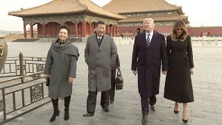
Xi: We call ourselves descendants of the dragon
Chinese President Xi Jinping and his wife Peng Liyuan invited US ...
Chinese President Xi Jinping and his wife Peng Liyuan invited US President Donald Trump and his wife Melania Trump to the ...
China flag | চীনের পতাকা | 中国国旗 #flag #drawing
China flag | চীনের পতাকা | 中国国旗 Unleash your creativity with our ...
China flag | চীনের পতাকা | 中国国旗 Unleash your creativity with our step-by-step guide on how to draw the **China ...
China is classified as Emerging region: BRIC: Brazil, Russia, India, and China – Economies noted for their rapid growth and increasing influence on global affairs. The level of income is Upper middle income.
News – Latest Updates and Headlines from Beijian Dao
Stay informed with the most recent news and important headlines from Beijian Dao. Here’s a roundup of the latest developments.
Loading...
Please note: The data used here has been primarily extracted from satellite readings. Deviations from exact values may occur, particularly regarding the height of elevations and population density. Land area and coastline measurements refer to average values at mean high tide.