Bet Shankhodhār
Welcome to Bet Shankhodhār, a Dry island in the Arabian Sea, part of the majestic Indian Ocean. This guide offers a comprehensive overview of what makes Bet Shankhodhār unique – from its geography and climate to its population, infrastructure, and beyond. Dive into the details:
- Geography and Size: Explore the island’s size and location.
- Climate and Weather: Weather patterns and temperature.
- Topography and Nature: Uncover the natural wonders of the island.
- Infrastructure and Travelling: Insights on reaching, staying, and making the most of your visit.
- News and Headlines: Latest News.
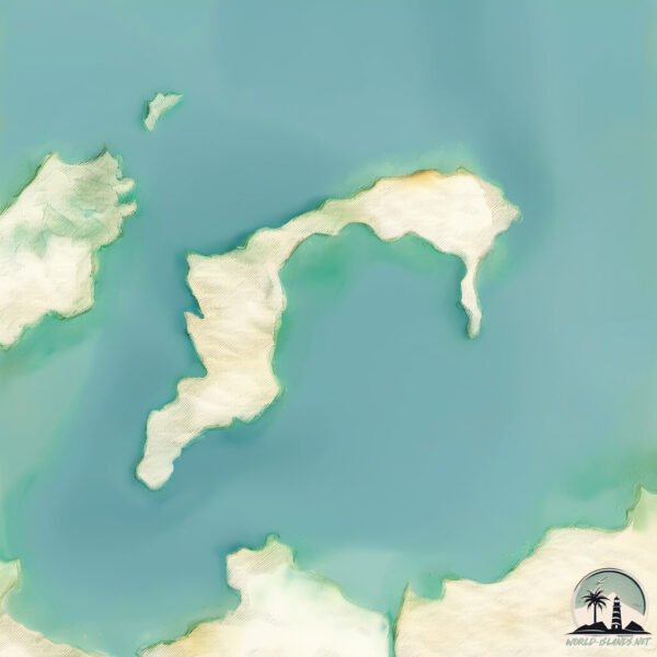
Geography and size of Bet Shankhodhār
Size: 10.9 km²
Coastline: 27.8 km
Ocean: Indian Ocean
Sea: Arabian Sea
Continent: Asia
Bet Shankhodhār is a Medium Island spanning 11 km² with a coastline of 28 km.
Archipel: –
Tectonic Plate: India – A major tectonic plate that initially moved northward at a rapid pace before colliding with the Eurasian Plate. This collision is responsible for the uplift of the Himalayas and the Tibetan Plateau.
The geographic heart of the island is pinpointed at these coordinates:
Latitude: 22.45531766 / Longitude: 69.11329278
Climate and weather of Bet Shankhodhār
Climate Zone: Dry
Climate Details: Hot Semi-Arid (Steppe) Climate
Temperature: Hot
Climate Characteristics: Features hot summers and mild to warm winters. Receives more rainfall than hot deserts but less than tropical savannas, leading to a somewhat more varied landscape.
Topography and nature of Bet Shankhodhār
Timezone: UTC+05:30
Timezone places: Asia/Kolkata
Max. Elevation: 10 m
Mean Elevation: 5 m
Vegetation: Sparse Vegetation
Tree Coverage: 70%
The mean elevation is 5 m. The highest elevation on the island reaches approximately 10 meters above sea level. The island is characterized by Plains: Flat, low-lying lands characterized by a maximum elevation of up to 200 meters. On islands, plains are typically coastal lowlands or central flat areas.
Dominating Vegetation: Sparse Vegetation
These regions have limited plant growth, typically due to extreme conditions like aridity or poor soils. Vegetation is scattered and consists of hardy plant species. Bet Shankhodhār has a tree cover of 70 %.
Vegetation: 5 vegetation zones – Highly Diverse Island
With five different vegetation zones, these islands offer a rich tapestry of ecosystems. The variety could include dense forests, open meadows, wetlands, coastal zones, and more. This level of diversity supports an intricate web of life, with each zone playing a vital role in the overall ecological health and balance of the island.
Infrastructure and Travelling to Bet Shankhodhār
Does the island have a public airport? no.
There is no public and scheduled airport on Bet Shankhodhār. The nearest airport is Jamnagar Airport, located 96 km away.
Does the island have a major port? no.
There are no major ports on Bet Shankhodhār. The closest major port is OKHA, approximately 1 km away.
The mean population of Bet Shankhodhār is 754 per km². Bet Shankhodhār is Densely Populated. The island belongs to India.
Continuing your journey, Kālubhār Tāpu is the next notable island, situated merely km away.
India is classified as Emerging region: BRIC: Brazil, Russia, India, and China – Economies noted for their rapid growth and increasing influence on global affairs. The level of income is Lower middle income.
News – Latest Updates and Headlines from Bet Shankhodhār
Stay informed with the most recent news and important headlines from Bet Shankhodhār. Here’s a roundup of the latest developments.
Please note: The data used here has been primarily extracted from satellite readings. Deviations from exact values may occur, particularly regarding the height of elevations and population density. Land area and coastline measurements refer to average values at mean high tide.