Big Burn Island
Welcome to Big Burn Island, a Continental island in the Labrador Sea, part of the majestic Atlantic Ocean. This guide offers a comprehensive overview of what makes Big Burn Island unique – from its geography and climate to its population, infrastructure, and beyond. Dive into the details:
- Geography and Size: Explore the island’s size and location.
- Climate and Weather: Weather patterns and temperature.
- Topography and Nature: Uncover the natural wonders of the island.
- Infrastructure and Travelling: Insights on reaching, staying, and making the most of your visit.
- News and Headlines: Latest News.
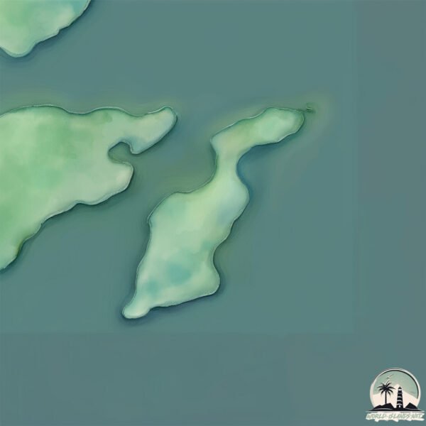
Geography and size of Big Burn Island
Size: 0.16 km²
Coastline: 2.7 km
Ocean: Atlantic Ocean
Sea: Labrador Sea
Continent: North America
Big Burn Island is a Tiny Island spanning 0.16 km² with a coastline of 2.7 km.
Archipel: –
Tectonic Plate: North America – Covers North America and parts of the Atlantic and Arctic Oceans, characterized by diverse geological features and varying levels of seismic activity.
The geographic heart of the island is pinpointed at these coordinates:
Latitude: 48.71684248 / Longitude: -53.83491988
Climate and weather of Big Burn Island
Climate Zone: Continental
Climate Details: Warm-Summer Humid Continental Climate
Temperature: Warm Summer
Climate Characteristics: Features warm summers and cold winters with consistent precipitation, common in higher latitudes.
Topography and nature of Big Burn Island
Timezone: UTC-03:30
Timezone places: America/St_Johns
Max. Elevation: 1 m
Mean Elevation: -1 m
Vegetation: Deciduous Needleleaf Forest
Tree Coverage: 86%
The mean elevation is -1 m. The highest elevation on the island reaches approximately 1 meters above sea level. The island is characterized by Plains: Flat, low-lying lands characterized by a maximum elevation of up to 200 meters. On islands, plains are typically coastal lowlands or central flat areas.
Dominating Vegetation: Deciduous Needleleaf Forest
Consists of needleleaf trees that shed their needles annually. This type of forest is less common and can be found in certain cold, northern regions. Big Burn Island has a tree cover of 86 %.
Vegetation: 2 vegetation zones – Low Diversity Island
Islands with two distinct vegetation zones offer slightly more ecological variety. These zones could be due to differences in elevation, moisture, or other environmental factors. While still limited in biodiversity, these islands may offer a contrast between the two zones, such as a coastline with mangroves and an inland area with grassland.
Infrastructure and Travelling to Big Burn Island
Does the island have a public airport? no.
There is no public and scheduled airport on Big Burn Island. The nearest airport is Gander International Airport / CFB Gander, located 85 km away.
Does the island have a major port? no.
There are no major ports on Big Burn Island. The closest major port is CLARENVILLE, approximately 64 km away.
The mean population of Big Burn Island is 0 per km². Big Burn Island is Uninhabited. The island belongs to Canada.
Continuing your journey, Willis Island is the next notable island, situated merely km away.
Big Burnt Island, Lake George - BoatUpstate.com


Canada is classified as Developed region: G7: Group of Seven – Major advanced economies, including Canada, France, Germany, Italy, Japan, the United Kingdom, and the United States. The level of income is High income: OECD.
News – Latest Updates and Headlines from Big Burn Island
Stay informed with the most recent news and important headlines from Big Burn Island. Here’s a roundup of the latest developments.
Please note: The data used here has been primarily extracted from satellite readings. Deviations from exact values may occur, particularly regarding the height of elevations and population density. Land area and coastline measurements refer to average values at mean high tide.