Big Cay Bokel
Welcome to Big Cay Bokel, a Tropical island in the Caribbean Sea, part of the majestic Atlantic Ocean. This guide offers a comprehensive overview of what makes Big Cay Bokel unique – from its geography and climate to its population, infrastructure, and beyond. Dive into the details:
- Geography and Size: Explore the island’s size and location.
- Climate and Weather: Weather patterns and temperature.
- Topography and Nature: Uncover the natural wonders of the island.
- Infrastructure and Travelling: Insights on reaching, staying, and making the most of your visit.
- News and Headlines: Latest News.
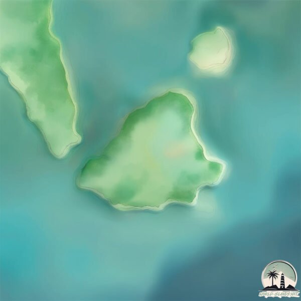
Geography and size of Big Cay Bokel
Size: 0.576 km²
Coastline: 3.2 km
Ocean: Atlantic Ocean
Sea: Caribbean Sea
Continent: North America
Big Cay Bokel is a Tiny Island spanning 0.576 km² with a coastline of 3.2 km.
Archipel: –
Tectonic Plate: North America – Covers North America and parts of the Atlantic and Arctic Oceans, characterized by diverse geological features and varying levels of seismic activity.
The geographic heart of the island is pinpointed at these coordinates:
Latitude: 17.17075039 / Longitude: -87.90489981
Climate and weather of Big Cay Bokel
Climate Zone: Tropical
Climate Details: Tropical Monsoon Climate
Temperature: Hot
Climate Characteristics: Characterized by heavy rainfall, high humidity, and uniformly high temperatures, but with a distinct short dry season. It features a seasonal reversal of prevailing wind directions.
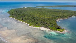
Topography and nature of Big Cay Bokel
Timezone: UTC-06:00
Timezone places: America/Chicago
Max. Elevation: 0 m
Mean Elevation: 0 m
Vegetation: Mangrove Forest
Tree Coverage: 77%
The mean elevation is 0 m. The highest elevation on the island reaches approximately 0 meters above sea level. The island is characterized by Plains: Flat, low-lying lands characterized by a maximum elevation of up to 200 meters. On islands, plains are typically coastal lowlands or central flat areas.
Dominating Vegetation: Mangrove Forest
Found in coastal areas and river deltas, these unique wetland ecosystems are adapted to saline conditions and are crucial for coastal protection and biodiversity. Big Cay Bokel has a tree cover of 77 %.
Vegetation: 2 vegetation zones – Low Diversity Island
Islands with two distinct vegetation zones offer slightly more ecological variety. These zones could be due to differences in elevation, moisture, or other environmental factors. While still limited in biodiversity, these islands may offer a contrast between the two zones, such as a coastline with mangroves and an inland area with grassland.
Infrastructure and Travelling to Big Cay Bokel
Does the island have a public airport? no.
There is no public and scheduled airport on Big Cay Bokel. The nearest airport is Dangriga Airport, located 41 km away.
Does the island have a major port? no.
There are no major ports on Big Cay Bokel. The closest major port is BELIZE CITY, approximately 48 km away.
The mean population of Big Cay Bokel is 49 per km². Big Cay Bokel is Gently Populated. The island belongs to Belize.
Continuing your journey, Blackbird Cay is the next notable island, situated merely km away.
Own Belize’s Most Beautiful Island – Caye Bokel


Belize is classified as Developing region: Regions characterized by lower income levels, with economies in the process of industrialization and modernization. The level of income is Lower middle income.
News – Latest Updates and Headlines from Big Cay Bokel
Stay informed with the most recent news and important headlines from Big Cay Bokel. Here’s a roundup of the latest developments.
Please note: The data used here has been primarily extracted from satellite readings. Deviations from exact values may occur, particularly regarding the height of elevations and population density. Land area and coastline measurements refer to average values at mean high tide.