Welcome to Big Farmer’s Cay, a Tropical island in the North Atlantic Ocean, part of the majestic Atlantic Ocean. This guide offers a comprehensive overview of what makes Big Farmer’s Cay unique – from its geography and climate to its population, infrastructure, and beyond. Dive into the details:
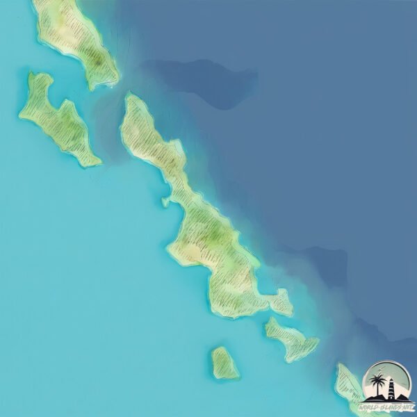
Geography and size of Big Farmer’s Cay
Size: 2.313 km²
Coastline: 12.6 km
Ocean: Atlantic Ocean
Sea: North Atlantic Ocean
Continent: North America
Big Farmer’s Cay is a Small Island spanning 2.3 km² with a coastline of 12.6 km.
Archipel: Bahama Islands – An archipelago in the Atlantic Ocean, known for their stunning beaches, coral reefs, and vibrant culture.
Tectonic Plate: North America – Covers North America and parts of the Atlantic and Arctic Oceans, characterized by diverse geological features and varying levels of seismic activity.
The geographic heart of the island is pinpointed at these coordinates:
Latitude: 23.9414803 / Longitude: -76.30022061
Climate and weather of Big Farmer’s Cay
Climate Zone: Tropical
Climate Details: Tropical Savanna, Wet
Temperature: Hot
Climate Characteristics: Defined by distinct wet and dry seasons with high temperatures year-round. Pronounced rainfall occurs during the wet season, while the dry season is marked by drought.
Topography and nature of Big Farmer’s Cay
Timezone: UTC-05:00
Timezone places: America/New_York
Max. Elevation: 6 m
Mean Elevation: -2 m
Vegetation: Deciduous Needleleaf Forest
Tree Coverage: 87%
The mean elevation is -2 m. The highest elevation on the island reaches approximately 6 meters above sea level. The island is characterized by Plains: Flat, low-lying lands characterized by a maximum elevation of up to 200 meters. On islands, plains are typically coastal lowlands or central flat areas.
Dominating Vegetation: Deciduous Needleleaf Forest
Consists of needleleaf trees that shed their needles annually. This type of forest is less common and can be found in certain cold, northern regions. Big Farmer’s Cay has a tree cover of 87 %.
Vegetation: 5 vegetation zones – Highly Diverse Island
With five different vegetation zones, these islands offer a rich tapestry of ecosystems. The variety could include dense forests, open meadows, wetlands, coastal zones, and more. This level of diversity supports an intricate web of life, with each zone playing a vital role in the overall ecological health and balance of the island.
Infrastructure and Travelling to Big Farmer’s Cay
Does the island have a public airport? no.
There is no public and scheduled airport on Big Farmer’s Cay. The nearest airport is Exuma International Airport, located 61 km away.
Does the island have a major port? no.
There are no major ports on Big Farmer’s Cay. The closest major port is NASSAU, approximately 170 km away.
The mean population of Big Farmer’s Cay is 35 per km². Big Farmer’s Cay is Gently Populated. The island belongs to The Bahamas.
Continuing your journey, Great Exuma is the next notable island, situated merely km away.
Little Farmer's Cay Exumas, Bahamas
We visit Little Farmer's Cay and explore to J.R.'s Woodworking shop. Such a friendly island!!Little Farmer's Cay Exumas, Bahamas
We visit Little Farmer's Cay and explore to J.R.'s Woodworking shop. ...
We visit Little Farmer's Cay and explore to J.R.'s Woodworking shop. Such a friendly island!!
Big Farmers Cay - Bahamas Aerial VIew
23°56,66N / 76°18,18W Exumas - Big Farmers Cay On this big island you ...
23°56,66N / 76°18,18W Exumas - Big Farmers Cay On this big island you can find several beautiful beaches and anchouridges.
Big Farmers Cay, Exumas
What an amazing anchorage!
What an amazing anchorage!
BIG FARMERS CAY, EXUMA CAYS IN THE BAHAMAS | IRIE CAT
s/v Irie Cat an aerial view of Big Farmers Cay, Exuma Cays in The ...
s/v Irie Cat an aerial view of Big Farmers Cay, Exuma Cays in The Bahamas. The crew of s/v irie cat has created a series of videos ...
SDA216 Lost and Found at Big Farmers Cay
Lost track of time, lost track of Lisa, and found far more than ...
Lost track of time, lost track of Lisa, and found far more than expected. Big Farmers Cay pulled us in, then pulled us right back into ...
SDA46 King Tides at Big Farmers Cay
We skip a beat and add sailing for a finale. Stay tuned to the end for ...
We skip a beat and add sailing for a finale. Stay tuned to the end for sailing! King tides can cause navigation problems.
Disappearing Sandbar - Big Farmer's Cay - Exuma Bahamas - GoPro Hero7 1440p
This is the beautiful disappearing sandbar at Big Farmer's Cay in ...
This is the beautiful disappearing sandbar at Big Farmer's Cay in Exuma, Bahamas - Also known as the secret sandbar called ...
Farmers Cay, Exuma Islands, Bahamas
Landing Farmers Cay, Exuma Islands, Bahamas. July 10, 2014. Ty's ...
Landing Farmers Cay, Exuma Islands, Bahamas. July 10, 2014. Ty's Cantina is a great stop when flying down the Exuma's.
Little Farmers Cay - Bahamas Aerial VIew
23°57,73N / 76°19,43W Exuma Cays - Little Farmers Cay On Little ...
23°57,73N / 76°19,43W Exuma Cays - Little Farmers Cay On Little Farmers Cay you find one of the only three villages in the ...
Farmer's Cay 20 Acres Beach Front Property
Welcome to Big Farmer's Cay in the pristine Exuma island chain—where ...
Welcome to Big Farmer's Cay in the pristine Exuma island chain—where crystal-clear turquoise waters meet untouched white ...
Sailing Exuma Cays - Compass Cay - Rudder Cut Cay - Big Farmers Cay
We just got back from 10 days in the southern Bahamas, Great Exuma and ...
We just got back from 10 days in the southern Bahamas, Great Exuma and the Exuma Cays. We sailed 21 foot Sea Pearls from ...
Jr The Wood Carver - Little Farmers Cay Exuma | Happy 50th Independence Bahamas 🇧🇸
Exuma Cays Interviews | Happy 50th Anniversary Bahamas ...
Exuma Cays Interviews | Happy 50th Anniversary Bahamas ----------------------------------------------------------------------------- Video ...
Farmers Cay, Exumas March 2017
This is our day spent on Little Farmer's Cay in the Exumas, Bahamas. ...
This is our day spent on Little Farmer's Cay in the Exumas, Bahamas. Feeding sea turtles, cleaning conch, lunch at the Ocean ...
ADVENTURE AROUND BIG FARMERS CAY, EXUMA CAYS IN THE BAHAMAS | IRIE CAT
A few unique experiences around Big Farmers Cay, Exuma Cays in The ...
A few unique experiences around Big Farmers Cay, Exuma Cays in The Bahamas. The water spout was a highlight. The crew of ...
Swimming with a Southern Stingray - Big Farmer's Cay - Exuma Bahamas - GoPro Hero7 1440p
Swimming with a Southern Stingray at Big Farmer's Cay in Exuma, ...
Swimming with a Southern Stingray at Big Farmer's Cay in Exuma, Bahamas -Saw this stingray swimming while at the ...
SDA34 5F Farmers Cay First Friday in February Festival
If you get the opportunity to attend the Farmers Cay First Friday in ...
If you get the opportunity to attend the Farmers Cay First Friday in February Festival, go for it! The people are the friendliest you'll ...
Sailing to Little Farmers Cay, Exuma, Bahamas- fun with sharks, great food, and new great friends
Little Farmers Cay quickly became a favorite stop and anchorage on our ...
Little Farmers Cay quickly became a favorite stop and anchorage on our cruise south through Exuma, Bahamas. Is a a tiny island ...
Farmers Cay, Bahamas
This is a hidden paradise that very few of us have had the pleasure of ...
This is a hidden paradise that very few of us have had the pleasure of visiting, enjoying and spend some time in it...
Welcome to Farmer's Cay Yacht Club & Marina!
Farmer's Cay
While in Farmer's Cay, Bahamas, we got stuck in a 7 day blow, where it ...
While in Farmer's Cay, Bahamas, we got stuck in a 7 day blow, where it blew winds, 30-45 knots the whole time.
Bahamas Farmers cay
Fun is always on the agenda. Meeting friendly people all over the world.
Fun is always on the agenda. Meeting friendly people all over the world.
Staniel Cay Adentures at Pig Beach The Bahamas
Staniel Cay Adventures provides exciting tours of the Exuma Cays with ...
Staniel Cay Adventures provides exciting tours of the Exuma Cays with a local Staniel Cay captain. Our professional licensed tour ...
Smooth sail from Little Farmers Cay to Staniel Cay / Big Majors Spot - Exuma’s
BIG FARMERS CAY SEA LIFE | IRIE CAT
This video features sea life around Big Farmers Cay, Exuma Cays in The ...
This video features sea life around Big Farmers Cay, Exuma Cays in The Bahamas. Sea life in their natural environment is truly ...
episode 14: magical moments in little farmer's cay
We leave Black Point and head 10.5 miles South to Little Farmer's Cay, ...
We leave Black Point and head 10.5 miles South to Little Farmer's Cay, a small island settlement with a couple of restaurants, ...
The Bahamas is classified as Developing region: Regions characterized by lower income levels, with economies in the process of industrialization and modernization. The level of income is High income: nonOECD.
News – Latest Updates and Headlines from Big Farmer’s Cay
Stay informed with the most recent news and important headlines from Big Farmer’s Cay. Here’s a roundup of the latest developments.
Loading...
Please note: The data used here has been primarily extracted from satellite readings. Deviations from exact values may occur, particularly regarding the height of elevations and population density. Land area and coastline measurements refer to average values at mean high tide.