Big Major’s Spot
Welcome to Big Major’s Spot, a Tropical island in the North Atlantic Ocean, part of the majestic Atlantic Ocean. This guide offers a comprehensive overview of what makes Big Major’s Spot unique – from its geography and climate to its population, infrastructure, and beyond. Dive into the details:
- Geography and Size: Explore the island’s size and location.
- Climate and Weather: Weather patterns and temperature.
- Topography and Nature: Uncover the natural wonders of the island.
- Infrastructure and Travelling: Insights on reaching, staying, and making the most of your visit.
- News and Headlines: Latest News.
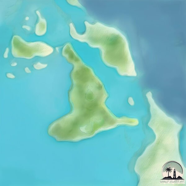
Geography and size of Big Major’s Spot
Size: 1.14 km²
Coastline: 6.2 km
Ocean: Atlantic Ocean
Sea: North Atlantic Ocean
Continent: North America
Big Major’s Spot is a Small Island spanning 1.1 km² with a coastline of 6.2 km.
Archipel: Bahama Islands – An archipelago in the Atlantic Ocean, known for their stunning beaches, coral reefs, and vibrant culture.
Tectonic Plate: North America – Covers North America and parts of the Atlantic and Arctic Oceans, characterized by diverse geological features and varying levels of seismic activity.
The geographic heart of the island is pinpointed at these coordinates:
Latitude: 24.183843 / Longitude: -76.45432886
Climate and weather of Big Major’s Spot
Climate Zone: Tropical
Climate Details: Tropical Savanna, Wet
Temperature: Hot
Climate Characteristics: Defined by distinct wet and dry seasons with high temperatures year-round. Pronounced rainfall occurs during the wet season, while the dry season is marked by drought.
Topography and nature of Big Major’s Spot
Timezone: UTC-05:00
Timezone places: America/New_York
Max. Elevation: 8 m
Mean Elevation: 7 m
Vegetation: Deciduous Needleleaf Forest
Tree Coverage: 87%
The mean elevation is 7 m. The highest elevation on the island reaches approximately 8 meters above sea level. The island is characterized by Plains: Flat, low-lying lands characterized by a maximum elevation of up to 200 meters. On islands, plains are typically coastal lowlands or central flat areas.
Dominating Vegetation: Deciduous Needleleaf Forest
Consists of needleleaf trees that shed their needles annually. This type of forest is less common and can be found in certain cold, northern regions. Big Major’s Spot has a tree cover of 87 %.
Vegetation: 3 vegetation zones – Moderately Diverse Island
These islands start to show a broader range of ecological niches. With three vegetation zones, they may offer a mix of ecosystems like coastal areas, inland woods, and perhaps a distinct wetland or dry area. This diversity supports a wider range of flora and fauna, making these islands more ecologically complex than those with minimal diversity.
Infrastructure and Travelling to Big Major’s Spot
Does the island have a public airport? no.
There is no public and scheduled airport on Big Major’s Spot. The nearest airport is Exuma International Airport, located 93 km away.
Does the island have a major port? no.
There are no major ports on Big Major’s Spot. The closest major port is NASSAU, approximately 140 km away.
The mean population of Big Major’s Spot is 35 per km². Big Major’s Spot is Gently Populated. The island belongs to The Bahamas.
Continuing your journey, Great Guana Cay is the next notable island, situated merely km away.
Pigs: Big Major Spot Island- Central Exuma's


The Bahamas is classified as Developing region: Regions characterized by lower income levels, with economies in the process of industrialization and modernization. The level of income is High income: nonOECD.
News – Latest Updates and Headlines from Big Major’s Spot
Stay informed with the most recent news and important headlines from Big Major’s Spot. Here’s a roundup of the latest developments.
Please note: The data used here has been primarily extracted from satellite readings. Deviations from exact values may occur, particularly regarding the height of elevations and population density. Land area and coastline measurements refer to average values at mean high tide.