Bingaram Island
Welcome to Bingaram Island, a Tropical island in the Laccadive Sea, part of the majestic Indian Ocean. This guide offers a comprehensive overview of what makes Bingaram Island unique – from its geography and climate to its population, infrastructure, and beyond. Dive into the details:
- Geography and Size: Explore the island’s size and location.
- Climate and Weather: Weather patterns and temperature.
- Topography and Nature: Uncover the natural wonders of the island.
- Infrastructure and Travelling: Insights on reaching, staying, and making the most of your visit.
- News and Headlines: Latest News.
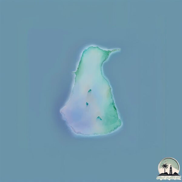
Geography and size of Bingaram Island
Size: 0.623 km²
Coastline: 3.8 km
Ocean: Indian Ocean
Sea: Laccadive Sea
Continent: Seven seas (open ocean)
Bingaram Island is a Tiny Island spanning 0.623 km² with a coastline of 3.8 km.
Archipel: Laccadive Islands – Also known as Lakshadweep, a group of islands off the southwestern coast of India, known for their pristine beauty and coral reefs.
Tectonic Plate: India – A major tectonic plate that initially moved northward at a rapid pace before colliding with the Eurasian Plate. This collision is responsible for the uplift of the Himalayas and the Tibetan Plateau.
The geographic heart of the island is pinpointed at these coordinates:
Latitude: 10.93972881 / Longitude: 72.28719916
Climate and weather of Bingaram Island
Climate Zone: Tropical
Climate Details: Tropical Monsoon Climate
Temperature: Hot
Climate Characteristics: Characterized by heavy rainfall, high humidity, and uniformly high temperatures, but with a distinct short dry season. It features a seasonal reversal of prevailing wind directions.
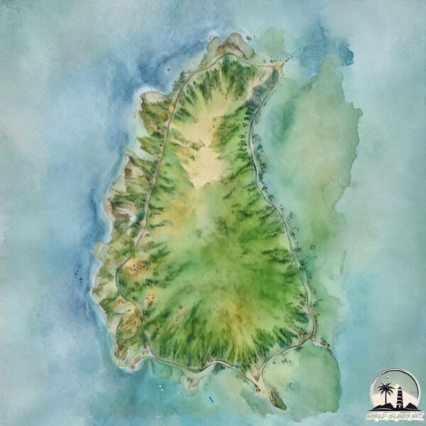
Topography and nature of Bingaram Island
Timezone: UTC+05:30
Timezone places:
Max. Elevation: 3 m
Mean Elevation: 2 m
Vegetation: Evergreen Needleleaf Forest
Tree Coverage: 42%
The mean elevation is 2 m. The highest elevation on the island reaches approximately 3 meters above sea level. The island is characterized by Plains: Flat, low-lying lands characterized by a maximum elevation of up to 200 meters. On islands, plains are typically coastal lowlands or central flat areas.
Dominating Vegetation: Evergreen Needleleaf Forest
Dominated by evergreen coniferous trees such as pines and firs, which retain their needle-like leaves throughout the year. These forests are often found in cooler climates. Bingaram Island has a tree cover of 42 %.
Vegetation: 1 vegetation zones – Minimal Diversity Island
These islands exhibit the most basic level of ecological diversity, often characterized by a single dominant vegetation type. This could be due to extreme environmental conditions, limited land area, or significant human impact. They represent unique ecosystems where specific species have adapted to thrive in these singular environments.
Infrastructure and Travelling to Bingaram Island
Does the island have a public airport? no.
There is no public and scheduled airport on Bingaram Island. The nearest airport is Agatti Airport, located 17 km away.
Does the island have a major port? no.
There are no major ports on Bingaram Island. The closest major port is AZHIKAL (AZHIKKAL), approximately 351 km away.
The mean population of Bingaram Island is 174 per km². Bingaram Island is Moderately Inhabited. The island belongs to India.
Continuing your journey, Ramanthali is the next notable island, situated merely km away.
Lakshadweep Bangaram Island 2025: Why No Hotels? Full Reality Update, Permit, Cost & Travel Guide 🌴


India is classified as Emerging region: BRIC: Brazil, Russia, India, and China – Economies noted for their rapid growth and increasing influence on global affairs. The level of income is Lower middle income.
News – Latest Updates and Headlines from Bingaram Island
Stay informed with the most recent news and important headlines from Bingaram Island. Here’s a roundup of the latest developments.
Please note: The data used here has been primarily extracted from satellite readings. Deviations from exact values may occur, particularly regarding the height of elevations and population density. Land area and coastline measurements refer to average values at mean high tide.