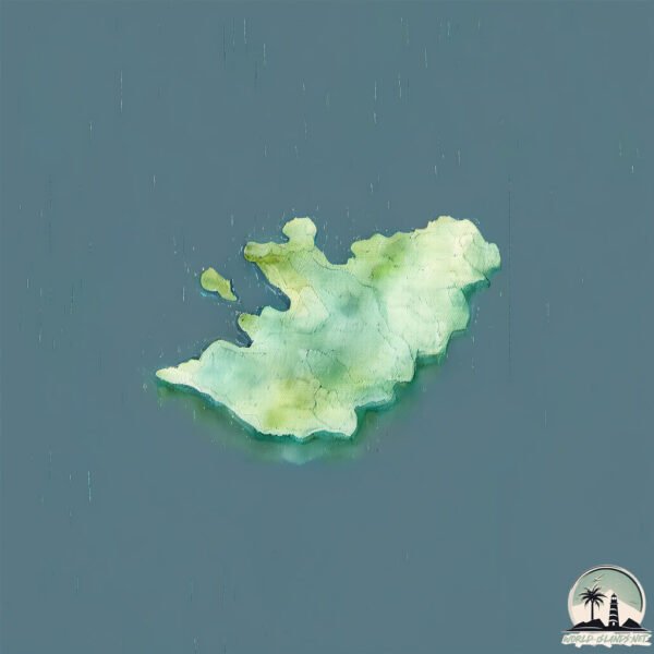
Welcome to Black Bear, a Polar island in the Labrador Sea, part of the majestic Atlantic Ocean. This guide offers a comprehensive overview of what makes Black Bear unique – from its geography and climate to its population, infrastructure, and beyond. Dive into the details:
Geography and size of Black Bear
Size: 3.987 km²
Coastline: 12.9 km
Ocean: Atlantic Ocean
Sea: Labrador Sea
Continent: North America
Black Bear is a Small Island spanning 4 km² with a coastline of 12.9 km.
Archipel: –
Tectonic Plate: North America – Covers North America and parts of the Atlantic and Arctic Oceans, characterized by diverse geological features and varying levels of seismic activity.
The geographic heart of the island is pinpointed at these coordinates:
Latitude: 55.06604534 / Longitude: -58.62009877
Climate and weather of Black Bear
Climate Zone: Polar
Climate Details: Tundra
Temperature: Cold
Climate Characteristics: The tundra climate features long, extremely cold winters and short, cool summers. Vegetation is limited to mosses, lichens, and small shrubs due to the low temperatures and short growing seasons. Biodiversity is low, but some specialized species thrive.
Topography and nature of Black Bear
Timezone: UTC-04:00
Timezone places: America/La_Paz
Max. Elevation: 49 m
Mean Elevation: 26 m
Vegetation: Herbaceous Cover
Tree Coverage: 52%
The mean elevation is 26 m. The highest elevation on the island reaches approximately 49 meters above sea level. The island is characterized by Plains: Flat, low-lying lands characterized by a maximum elevation of up to 200 meters. On islands, plains are typically coastal lowlands or central flat areas.
Dominating Vegetation: Herbaceous Cover
Comprising mainly of grasses, herbs, and ferns, these areas are common in prairies, meadows, and savannas, and can vary widely in species composition. Black Bear has a tree cover of 52 %.
Vegetation: 5 vegetation zones – Highly Diverse Island
With five different vegetation zones, these islands offer a rich tapestry of ecosystems. The variety could include dense forests, open meadows, wetlands, coastal zones, and more. This level of diversity supports an intricate web of life, with each zone playing a vital role in the overall ecological health and balance of the island.
Infrastructure and Travelling to Black Bear
Does the island have a public airport? no.
There is no public and scheduled airport on Black Bear. The nearest airport is Makkovik Airport, located 61 km away.
Does the island have a major port? no.
There are no major ports on Black Bear. The closest major port is GOOSE BAY, approximately 263 km away.
The mean population of Black Bear is 0 per km². Black Bear is Uninhabited. The island belongs to Canada.
Continuing your journey, Long Tickle is the next notable island, situated merely km away.
Bear Island - Donald Sutherland, Richard Widmark - British Canadian thriller adventure - Full Movie
Film: Bear Island - Donald Sutherland, Richard Widmark - British Canadian thriller adventure - Full Movie Bear Island - Donald ...Bear Island - Donald Sutherland, Richard Widmark - British Canadian thriller adventure - Full Movie
Film: Bear Island - Donald Sutherland, Richard Widmark - British ...
Film: Bear Island - Donald Sutherland, Richard Widmark - British Canadian thriller adventure - Full Movie Bear Island - Donald ...
Bear Island knows no king but the King in the North, whose name is STARK
''The House of Black and White'' (Game of Thrones: Season 5 Episode 2) ...
''The House of Black and White'' (Game of Thrones: Season 5 Episode 2) game of thrones 5x02 stannis baratheon davos ...
House Mormont Of Bear Island | The North | House Of The Dragon / ASOIAF History & Lore Explained
In this video, we dive deep into the legendary House Mormont, one of ...
In this video, we dive deep into the legendary House Mormont, one of the oldest and most loyal houses of the North. From their ...
Monsters of Kodiak: Presented by Sig Sauer… Watch it now on our channel. Subscribe now!
Subscribe to our channel and watch the full film behind Mark Heck's ...
Subscribe to our channel and watch the full film behind Mark Heck's potential WORLD RECORD archery brown bear. #hunting ...
Black Bear Island Lodge Intro Video Northern Saskatchewan Canada
Fly in Fishing Lodge in Northern Saskatchewan Canada. Trophy Pike ...
Fly in Fishing Lodge in Northern Saskatchewan Canada. Trophy Pike Trophy Walleye. Full American Plan only.
Black Bear - Vancouver Island
I caught sight of this black bear on Vancouver Island May '07. He ...
I caught sight of this black bear on Vancouver Island May '07. He didn't seem too worried about me filming him as long as I kept ...
Bear Island (1979) | The Polar Secret & Arctic Death Game | Retro Adventure Thriller HD
Bear Island (1979) | The Polar Secret & Arctic Death Game | Retro ...
Bear Island (1979) | The Polar Secret & Arctic Death Game | Retro Adventure Thriller HD Frozen. Isolated. Deadly. Explore Bear ...
Accordion Feature - The Dark Island, Black Bear, Reel Of Tulloch
Accordion Feature - The Dark Island, Black Bear, Reel Of Tulloch - Jim ...
Accordion Feature - The Dark Island, Black Bear, Reel Of Tulloch - Jim MacLeod Band & Guests.
The American Black Bear is SCARY
Lyanna Mormont - Lady of Courage | Game Of Thrones
Ocean Clips Entertainment This channel is for Die-hard Fans of Movies, ...
Ocean Clips Entertainment This channel is for Die-hard Fans of Movies, TV Series, Games and all other kinds of the entertainment ...
Polar Bears Don't Bluff: Why Lying Down Could Be Fatal!
Facing a polar bear, the largest land predator, demands calm and ...
Facing a polar bear, the largest land predator, demands calm and strategy. Back away slowly, avoid running, and never try to ...
Bear Hunting | ours | orso | دب
Deep in the heart of the wild forest, we captured a rare and powerful ...
Deep in the heart of the wild forest, we captured a rare and powerful moment a bear roaming freely in its natural habitat. This short ...
NEVER do these 3 things near a bear!
DREAM Black Bear Hunt on Vancouver Island | Canada in the Rough
From the Canada in the Rough Archive: In this episode, host Kevin ...
From the Canada in the Rough Archive: In this episode, host Kevin Beasley takes his Dad on his dream Black Bear hunt on ...
No one can question the Queen of Bear Island.#movie #shorts #film
Black Bear Island Lodge Fishing 2010
With over 597 Trophy Pike caught in 2010 this video is just a sample ...
With over 597 Trophy Pike caught in 2010 this video is just a sample of what a difference a fly-in lake that has almost no pressure ...
Lyanna Mormont - Lady of Bear island || Game of Thrones
[Lyanna Mormont] : Your son was butchered at the Red Wedding, Lord ...
[Lyanna Mormont] : Your son was butchered at the Red Wedding, Lord Manderly, but you refused the call. You swore allegiance ...
what if you shoot a Polar Bear?🤔#shorts
Guests arrive on Black Bear Island Lake to visit Black Bear Island Lodge
A flight from Osprey Wings (La Ronge, SK, Canada) with guests ready ...
A flight from Osprey Wings (La Ronge, SK, Canada) with guests ready for a fishing trip of Trophy Northern Pike and Walleye.
Black Bear Island Lodge Fishing 2014 Season
Trophy Pike and Walleye on the famous Churchill River System in ...
Trophy Pike and Walleye on the famous Churchill River System in Northern Saskatchewan at Black Bear Island Lodge ...
Bear Island by Alistair MacLean [Part 2] | Full Audiobook
Bear Island by Alistair MacLean [Part 2] | Full Audiobook Welcome to ...
Bear Island by Alistair MacLean [Part 2] | Full Audiobook Welcome to Alistair MacLean Audiobooks! Here you'll find a wide ...
Up at the Cabin: Prince of Wales Island Black Bear | S5E16 | MeatEater
Last spring, Steve decided to pass up an opportunity to kill a black ...
Last spring, Steve decided to pass up an opportunity to kill a black bear in favor of an extended up close and personal experience.
Craziest Bear attack of all time 😱 #shorts
Bear Stalks Family Along Hiking Trail 😳
'He's following you, babe' — Watch as a bear stalks a family of hikers ...
'He's following you, babe' — Watch as a bear stalks a family of hikers along a trail in Whistler, Canada » Sign up for our ...
Grizzly Bear vs Kodiak bear Who's Deadlier🤔
Who's truly the ultimate bear in the wild: the Grizzly Bear or the ...
Who's truly the ultimate bear in the wild: the Grizzly Bear or the Kodiak Bear? Discover the unique power, survival tactics, and ...
Canada is classified as Developed region: G7: Group of Seven – Major advanced economies, including Canada, France, Germany, Italy, Japan, the United Kingdom, and the United States. The level of income is High income: OECD.
News – Latest Updates and Headlines from Black Bear
Stay informed with the most recent news and important headlines from Black Bear. Here’s a roundup of the latest developments.
Loading...
Please note: The data used here has been primarily extracted from satellite readings. Deviations from exact values may occur, particularly regarding the height of elevations and population density. Land area and coastline measurements refer to average values at mean high tide.


![Bear Island by Alistair MacLean [Part 2] | Full Audiobook](https://i.ytimg.com/vi/AKDklNTxeJg/mqdefault.jpg)