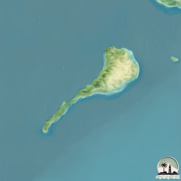
Welcome to Blackwood, a Tropical island in the Coral Sea, part of the majestic Pacific Ocean. This guide offers a comprehensive overview of what makes Blackwood unique – from its geography and climate to its population, infrastructure, and beyond. Dive into the details:
Geography and size of Blackwood
Size: 1.956 km²
Coastline: 10.4 km
Ocean: Pacific Ocean
Sea: Coral Sea
Continent: Oceania
Blackwood is a Small Island spanning 2 km² with a coastline of 10.4 km.
Archipel: –
Tectonic Plate: Australia – A major tectonic plate covering Australia, New Zealand, and parts of the Indian and Pacific Oceans, known for its relative stability and occasional seismic activity.
The geographic heart of the island is pinpointed at these coordinates:
Latitude: -14.21421257 / Longitude: 144.22215576
Climate and weather of Blackwood
Climate Zone: Tropical
Climate Details: Tropical Savanna, Wet
Temperature: Hot
Climate Characteristics: Defined by distinct wet and dry seasons with high temperatures year-round. Pronounced rainfall occurs during the wet season, while the dry season is marked by drought.
Topography and nature of Blackwood
Timezone: UTC+10:00
Timezone places: Australia/Sydney
Max. Elevation: 64 m
Mean Elevation: 41 m
Vegetation: Evergreen Needleleaf Forest
Tree Coverage: 92%
The mean elevation is 41 m. The highest elevation on the island reaches approximately 64 meters above sea level. The island is characterized by Plains: Flat, low-lying lands characterized by a maximum elevation of up to 200 meters. On islands, plains are typically coastal lowlands or central flat areas.
Dominating Vegetation: Evergreen Needleleaf Forest
Dominated by evergreen coniferous trees such as pines and firs, which retain their needle-like leaves throughout the year. These forests are often found in cooler climates. Blackwood has a tree cover of 92 %.
Vegetation: 6 vegetation zones – Very Highly Diverse Island
Islands in this range are ecological powerhouses, showcasing a wide array of vegetation zones. Each zone, from lush rainforests to arid scrublands, coastal mangroves to mountainous regions, contributes to a complex and interdependent ecosystem. These islands are often hotspots of biodiversity, supporting numerous species and intricate ecological processes.
Infrastructure and Travelling to Blackwood
Does the island have a public airport? no.
There is no public and scheduled airport on Blackwood. The nearest airport is Coen Airport, located 132 km away.
Does the island have a major port? no.
There are no major ports on Blackwood. The closest major port is CAPE FLATTERY HARBOR, approximately 149 km away.
The mean population of Blackwood is 0 per km². Blackwood is Uninhabited. The island belongs to Australia.
Continuing your journey, Wallaby Island is the next notable island, situated merely km away.
The Last Broadcast from Blackwood Island: "The Voice in the Dark"
Tune in to the last transmission from Blackwood Island, where the crew of a research vessel discovers a mysterious signal that ...The Last Broadcast from Blackwood Island: "The Voice in the Dark"
Tune in to the last transmission from Blackwood Island, where the crew ...
Tune in to the last transmission from Blackwood Island, where the crew of a research vessel discovers a mysterious signal that ...
Uncovering the Dark Secrets of Blackwood Island: A Descent into Madness and Terror at the Abandon...
What happens when the past and present collide on a remote island ...
What happens when the past and present collide on a remote island shrouded in mystery and terror? Join me as I delve into the ...
Abandoned on Blackwood Island: Uncovering the Dark Secrets of My Grandfather's Forgotten Lighthou...
What happens when you're forced to confront your darkest fears in the ...
What happens when you're forced to confront your darkest fears in the most isolated of places? For Dean, a reclusive ...
Blackwood Island | Intermediate English Listening Practice [B1 Vocabulary & Quiz]
In this thrilling story, we bring you Blackwood Island, a high-stakes ...
In this thrilling story, we bring you Blackwood Island, a high-stakes mystery about an elite interview that turns into a fight for ...
"Captain William Blackwood's Haunted Legacy: The Curse of Blackwood Island"
Description: Prepare to embark on a spine-tingling journey into the ...
Description: Prepare to embark on a spine-tingling journey into the chilling tale of Captain William Blackwood and the haunted ...
A Haunted Island - By Algernon Blackwood (a very creepy tale)
A Haunted Island” was written by Algernon Blackwood and first appeared ...
A Haunted Island” was written by Algernon Blackwood and first appeared in Pall Mall Magazine, Vol. 17, No. 72, in 1899. Its first ...
Blackwood Island pt 1
A girl is stranded on an island inhabited by elves.
A girl is stranded on an island inhabited by elves.
Bold Adventure on Blackwood Island: The Brave Treasure Hunter's Journey Through Secrets , Mysteries
Man Visits Scary Inbred Family! #joerogan #storytime
The Island That Doesn’t Let You Leave #horror #scary #ghost #horrorstories #creepy #horrorstory
In 1953, an entire family disappeared from their private island near ...
In 1953, an entire family disappeared from their private island near San Francisco. What happened next will make your skin crawl.
A Haunted Island - Algernon Blackwood
One of Blackwood's supernatural tales, not...quite a ghost story. But ...
One of Blackwood's supernatural tales, not...quite a ghost story. But a haunting for sure, set, as his best stories are, in the ...
These Beaches in Cornwall are a MUST-VISIT! #travel #cornwall #england #uktravel #travelling #uk
Blackwood Island pt 2
A girl is stranded on an island inhabited by elves.
A girl is stranded on an island inhabited by elves.
'BLACKWOOD PARK' - KING ISLAND
Blackwood island - possible new content form
Blackwood Island pt 4
A girl is stranded...the end.
A girl is stranded...the end.
All islands of the second sea #bloxfruits
Blackwood Island pt 3
A girl is stranded on an island inhabited by elves.
A girl is stranded on an island inhabited by elves.
A Haunted Island By: Algernon Blackwood - Uncanny Tales
Thank you for watching. 0:00:02 - A Haunted Island By: Algernon ...
Thank you for watching. 0:00:02 - A Haunted Island By: Algernon Blackwood I hope you enjoyed the video. Please Like, Comment ...
The mysterious island of Captain Blackwood
The Mysterious Island of Captain Blackwood As the sun set over the ...
The Mysterious Island of Captain Blackwood As the sun set over the horizon, a strong gust of wind blew through the small village ...
Black Hill & Silent Island - Tales of the night forest [Full Album]
We share post-rock songs, albums and playlists. Artist: Black Hill & ...
We share post-rock songs, albums and playlists. Artist: Black Hill & Silent Island (Hungary) Album: Tales of the night forest (2018) ...
Floating Turtle 💀☠️ #roblox #bloxfruits
A Haunted Island by Algernon Blackwood - full audiobook and text
A Haunted Island by Algernon Blackwood Read by Chiquito Crasto Edited ...
A Haunted Island by Algernon Blackwood Read by Chiquito Crasto Edited by BrainReadsAudio.
The Haunted Island by Algernon Blackwood
A collection of fifteen (Audio Book) stories featuring ghoulies, ...
A collection of fifteen (Audio Book) stories featuring ghoulies, ghosties, long-leggedy beasties and things that go bump in the night ...
Australia is classified as Developed region: nonG7: Developed economies outside of the Group of Seven, characterized by high income and advanced economic structures. The level of income is High income: OECD.
News – Latest Updates and Headlines from Blackwood
Stay informed with the most recent news and important headlines from Blackwood. Here’s a roundup of the latest developments.
Loading...
Please note: The data used here has been primarily extracted from satellite readings. Deviations from exact values may occur, particularly regarding the height of elevations and population density. Land area and coastline measurements refer to average values at mean high tide.


![Blackwood Island | Intermediate English Listening Practice [B1 Vocabulary & Quiz]](https://i.ytimg.com/vi/LnGCouGV9hw/mqdefault.jpg)


![Black Hill & Silent Island - Tales of the night forest [Full Album]](https://i.ytimg.com/vi/mTLunRuCGQQ/mqdefault.jpg)


