Blanca
Welcome to Blanca, a Temperate island in the South Pacific Ocean, part of the majestic Pacific Ocean. This guide offers a comprehensive overview of what makes Blanca unique – from its geography and climate to its population, infrastructure, and beyond. Dive into the details:
- Geography and Size: Explore the island’s size and location.
- Climate and Weather: Weather patterns and temperature.
- Topography and Nature: Uncover the natural wonders of the island.
- Infrastructure and Travelling: Insights on reaching, staying, and making the most of your visit.
- News and Headlines: Latest News.
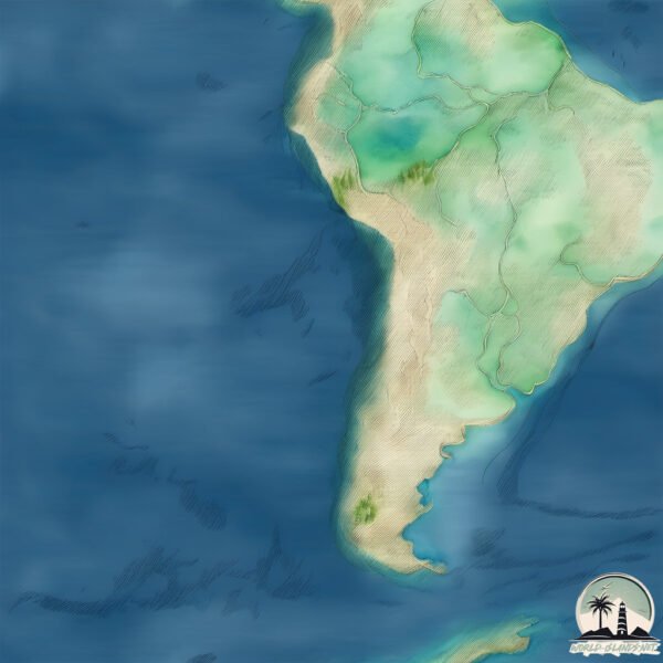
Geography and size of Blanca
Size: 8.258 km²
Coastline: 22.2 km
Ocean: Pacific Ocean
Sea: South Pacific Ocean
Continent: South America
Blanca is a Small Island spanning 8.3 km² with a coastline of 22.2 km.
Archipel: Cordillera Patagónica Insular – A series of islands in the Patagonian region, known for their dramatic landscapes and part of the Andean mountain range.
Tectonic Plate: South America – A major plate covering the South American continent and part of the Atlantic Ocean, known for the Andes mountain range and significant seismic and volcanic activity.
The geographic heart of the island is pinpointed at these coordinates:
Latitude: -42.10271882 / Longitude: -75.76541855
Climate and weather of Blanca
Climate Zone: Temperate
Climate Details: Subpolar Oceanic Climate
Temperature: Cold Summer
Climate Characteristics: Predominantly cold with cool summers and no dry season. Often found in coastal areas at higher latitudes or on islands.
Topography and nature of Blanca
Timezone: UTC-04:00
Timezone places: America/La_Paz
Max. Elevation: 401 m
Mean Elevation: 169 m
Vegetation: Herbaceous Cover
Tree Coverage: 51%
The mean elevation is 169 m. The highest elevation on the island reaches approximately 401 meters above sea level. The island is characterized by Hills: Gently sloping landforms with rounded tops, having a maximum elevation between 200 and 500 meters. Hills contribute to a varied landscape on islands.
Dominating Vegetation: Herbaceous Cover
Comprising mainly of grasses, herbs, and ferns, these areas are common in prairies, meadows, and savannas, and can vary widely in species composition. Blanca has a tree cover of 51 %.
Vegetation: 8 vegetation zones – Very Highly Diverse Island
Islands in this range are ecological powerhouses, showcasing a wide array of vegetation zones. Each zone, from lush rainforests to arid scrublands, coastal mangroves to mountainous regions, contributes to a complex and interdependent ecosystem. These islands are often hotspots of biodiversity, supporting numerous species and intricate ecological processes.
Infrastructure and Travelling to Blanca
Does the island have a public airport? no.
There is no public and scheduled airport on Blanca. The nearest airport is FAP Lieutenant Jaime Andres de Montreuil Morales Airport, located 11 km away.
Does the island have a major port? yes.
Blanca is home to a major port. The following ports are situated on the island: .
The mean population of Blanca is 32 per km². Blanca is Gently Populated. The island belongs to Chile.
Continuing your journey, Ursula is the next notable island, situated merely km away.
Dino Park Water Park Lanzarote-HL Paradise Island, Playa Blanca, Islas Canarias, España


Chile is classified as Emerging region: G20: Group of Twenty – Major economies comprising both developed and emerging countries, representing the world’s largest economies. The level of income is Upper middle income.
News – Latest Updates and Headlines from Blanca
Stay informed with the most recent news and important headlines from Blanca. Here’s a roundup of the latest developments.
Please note: The data used here has been primarily extracted from satellite readings. Deviations from exact values may occur, particularly regarding the height of elevations and population density. Land area and coastline measurements refer to average values at mean high tide.