Welcome to Bodo, a Continental island in the Gulf of Bothnia, part of the majestic Atlantic Ocean. This guide offers a comprehensive overview of what makes Bodo unique – from its geography and climate to its population, infrastructure, and beyond. Dive into the details:
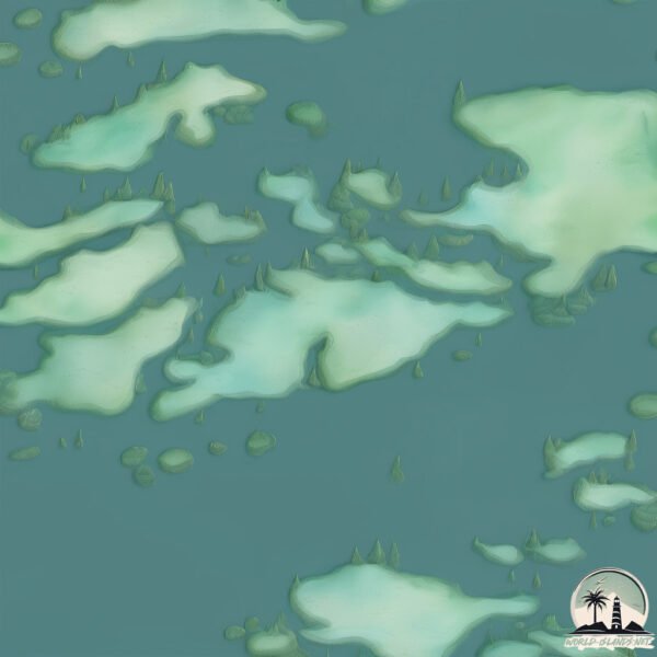
Geography and size of Bodo
Size: 1.343 km²
Coastline: 9.6 km
Ocean: Atlantic Ocean
Sea: Gulf of Bothnia
Continent: Europe
Bodo is a Small Island spanning 1.3 km² with a coastline of 9.6 km.
Archipel: –
Tectonic Plate: Eurasia – One of the world’s largest tectonic plates, the Eurasian Plate covers a significant portion of Europe and Asia. It’s characterized by diverse geological features, including the Ural Mountains, the European Plain, and the Himalayas formed from its collision with the Indian Plate.
The geographic heart of the island is pinpointed at these coordinates:
Latitude: 59.91030734 / Longitude: 21.76008913
Climate and weather of Bodo
Climate Zone: Continental
Climate Details: Warm-Summer Humid Continental Climate
Temperature: Warm Summer
Climate Characteristics: Features warm summers and cold winters with consistent precipitation, common in higher latitudes.
Topography and nature of Bodo
Timezone: UTC+02:00
Timezone places: Europe/Helsinki
Max. Elevation: 35 m
Mean Elevation: 31 m
Vegetation: Evergreen Needleleaf Forest
Tree Coverage: 56%
The mean elevation is 31 m. The highest elevation on the island reaches approximately 35 meters above sea level. The island is characterized by Plains: Flat, low-lying lands characterized by a maximum elevation of up to 200 meters. On islands, plains are typically coastal lowlands or central flat areas.
Dominating Vegetation: Evergreen Needleleaf Forest
Dominated by evergreen coniferous trees such as pines and firs, which retain their needle-like leaves throughout the year. These forests are often found in cooler climates. Bodo has a tree cover of 56 %.
Vegetation: 3 vegetation zones – Moderately Diverse Island
These islands start to show a broader range of ecological niches. With three vegetation zones, they may offer a mix of ecosystems like coastal areas, inland woods, and perhaps a distinct wetland or dry area. This diversity supports a wider range of flora and fauna, making these islands more ecologically complex than those with minimal diversity.
Infrastructure and Travelling to Bodo
Does the island have a public airport? no.
There is no public and scheduled airport on Bodo. The nearest airport is Turku Airport, located 86 km away.
Does the island have a major port? no.
There are no major ports on Bodo. The closest major port is PARGAS, approximately 52 km away.
The mean population of Bodo is 20 per km². Bodo is Gently Populated. The island belongs to Finland.
Continuing your journey, Storkvivas is the next notable island, situated merely km away.
Bodo Norway Travel Guide: 16 BEST Things To Do In Bodø
This Bodo travel guide shares the best things to do in Bodo. -------------- How to travel more and visit your dream destinations ...Bodo Norway Travel Guide: 16 BEST Things To Do In Bodø
This Bodo travel guide shares the best things to do in Bodo. ...
This Bodo travel guide shares the best things to do in Bodo. -------------- How to travel more and visit your dream destinations ...
MUST SEE PLACES IN NORWAY (part 3) #bodo #visitnorway #norge
Norwegian Nature: Vågøya island outside Bodø city
Some clips taken on a kayak trip around beautiful Vågøya outside Bodø ...
Some clips taken on a kayak trip around beautiful Vågøya outside Bodø city in Northern Norway. The distance of this trip ended up ...
"Discover Bodø: Norway's Arctic Gem! 🇳🇴❄️" #travel #shorts
"Welcome to Bodø, Norway's Arctic gem! Explore stunning fjords, ...
"Welcome to Bodø, Norway's Arctic gem! Explore stunning fjords, witness the midnight sun, and experience the vibrant local ...
Norway | Lofoten Moskenes Island Trek | Day 0: Exploring Bodø, the Gateway to the Lofoten Islands
In this solo travel video, I set out to explore Bodo, Norway, first, ...
In this solo travel video, I set out to explore Bodo, Norway, first, before heading out to Lofoten for my Moskenes Island crossing ...
Landegode Island in Bodo Norway
Visiting Landegode Island onboard The Quest.
Visiting Landegode Island onboard The Quest.
48 hours in Bodo, Norway #travel #shorts #timestravel
Adventure-packed Bodo, in northern Norway, is a European Capital of ...
Adventure-packed Bodo, in northern Norway, is a European Capital of Culture with added mountain walks, saunas and delicious ...
Beautiful Lofoten Island Norway Bodø
Best Ways to Get to The Lofoten Islands, Norway
You definitely want to watch this video before going to the Lofoten ...
You definitely want to watch this video before going to the Lofoten islands so you don't make any of the biggest (expensive) ...
Beautiful #beach right outside of Bodø. #Hovdsundet. #adventure #vacation
Bodo,Norway
Hey guys welcome to Top Travel. Bodo is located on a prominent ...
Hey guys welcome to Top Travel. Bodo is located on a prominent peninsula protruding out into the Norwegian Sea, in a ...
Bodø, Noruega 🗺️
AHORA VIVO ACA Estoy en un lugar que se llama Bodø, en Noruega ES A ...
AHORA VIVO ACA Estoy en un lugar que se llama Bodø, en Noruega ES A 12.451 KM DE ALMAGRO (mi casa original) ...
48 hours in Bonny Island feels like a Lifetime as @vivianokezie explores our wonders.
The Ultimate Arctic Norway Road Trip: 8 Days in the Lofotens
Save this 8 Day Lofotens Mini Guide and follow @megmitchell123 for ...
Save this 8 Day Lofotens Mini Guide and follow @megmitchell123 for more itineraries and hikes! We explored the Lofoten Islands ...
Bodo-Bonny Road – Advancing Connectivity, Strengthening Communities
Julius Berger is proud to support the Federal Government in achieving ...
Julius Berger is proud to support the Federal Government in achieving this historic milestone as the Bodo–Bonny Road is ...
Bodo's Mjelle Beach - The Perfect Place to Take A Picture 📷 Norway Travel #shorts
Receive rent free accommodations for keeping homes secure while owners ...
Receive rent free accommodations for keeping homes secure while owners are away ➡️
https://bit.ly/3B0fgVk Mjelle Beach is ...
The world's most powerful tidal current
Near Bodø in Norway, there's the strongest tidal current in the world: ...
Near Bodø in Norway, there's the strongest tidal current in the world: Saltstraumen Maelstrom, a constantly-changing rush of ...
Descending in Bodø guided by the midnight sun. #norway #bodo #solotravel #hiking
Bodø in Norway was the perfect stop before hopping on the ferry to ...
Bodø in Norway was the perfect stop before hopping on the ferry to Lofoten. This gave me a chance to stock up on supplies for my ...
“Bodø: The Arctic Gateway of the Culture and Nature“#shorts #travel #viralvideo #Norway
Amazing beach right outside of Bodo Hovdsundet Norway. #norway #beach #short #bodo Hovdsundet
World Strongest Whirlpool, Salstraumen in Norway #nature
Disclaimer: This information is taken from the internet which may or ...
Disclaimer: This information is taken from the internet which may or may not be true we DO NOT want to spread any fake news.
Norway, Saltstraumen Maelstrom #shortsvideo
shortsvideo Norway, Saltstraumen Maelstrom Saltstraumen is one of the ...
shortsvideo Norway, Saltstraumen Maelstrom Saltstraumen is one of the strongest tidal currents in the world (Norway), with ...
Maldives private island on budget/information in Bodo language and in Hindi
Hello everyone Khulumbai My name is Barasha Rani Basumatary. Welcome ...
Hello everyone Khulumbai My name is Barasha Rani Basumatary. Welcome back to my channel. My channel is based on my ...
Journey from Bodo to Lofoten Island | Trip To Norway | Monamy‘s Voyage | Moskenes ferry to Lofoten.
bodo #adventure #travel #norway Video Link: ...
Finland is classified as Developed region: nonG7: Developed economies outside of the Group of Seven, characterized by high income and advanced economic structures. The level of income is High income: OECD.
News – Latest Updates and Headlines from Bodo
Stay informed with the most recent news and important headlines from Bodo. Here’s a roundup of the latest developments.
Loading...
Please note: The data used here has been primarily extracted from satellite readings. Deviations from exact values may occur, particularly regarding the height of elevations and population density. Land area and coastline measurements refer to average values at mean high tide.