Bolshoy Shantar
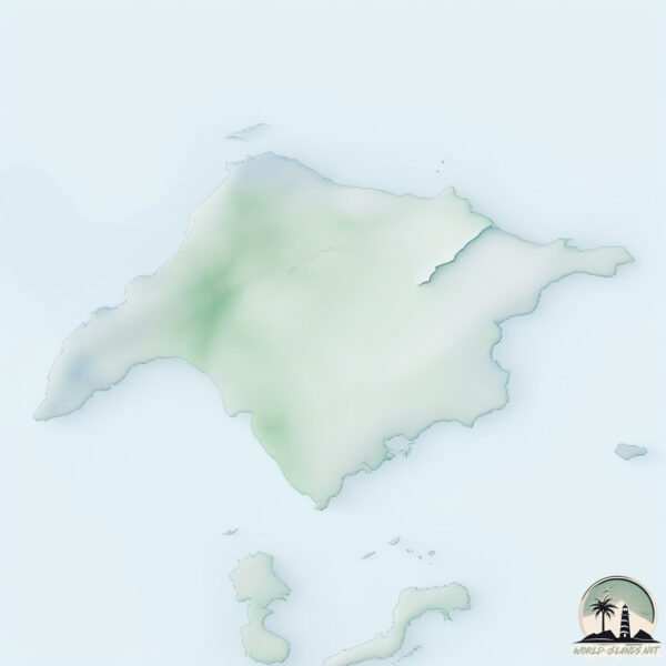
Welcome to Bolshoy Shantar, a Continental island in the Sea of Okhotsk, part of the majestic Pacific Ocean. This guide offers a comprehensive overview of what makes Bolshoy Shantar unique – from its geography and climate to its population, infrastructure, and beyond. Dive into the details:
- Geography and Size: Explore the island’s size and location.
- Climate and Weather: Weather patterns and temperature.
- Topography and Nature: Uncover the natural wonders of the island.
- Infrastructure and Travelling: Insights on reaching, staying, and making the most of your visit.
- News and Headlines: Latest News.
Geography and size of Bolshoy Shantar
Size: 1822 km²
Coastline: 373 km
Ocean: Pacific Ocean
Sea: Sea of Okhotsk
Continent: Asia
Bolshoy Shantar is a Very Large Island spanning 1822 km² with a coastline of 373 km.
Archipel: Shantar Islands – A group of Russian islands in the Sea of Okhotsk, known for their untouched wilderness and rich biodiversity.
Tectonic Plate: Eurasia – One of the world’s largest tectonic plates, the Eurasian Plate covers a significant portion of Europe and Asia. It’s characterized by diverse geological features, including the Ural Mountains, the European Plain, and the Himalayas formed from its collision with the Indian Plate.
The geographic heart of the island is pinpointed at these coordinates:
Latitude: 54.92992742 / Longitude: 137.71529066
Climate and weather of Bolshoy Shantar
Climate Zone: Continental
Climate Details: Subarctic Climate
Temperature: Cold Summer
Climate Characteristics: Characterized by long, extremely cold winters and short, cool summers, often found in northern latitudes of North America and Eurasia.
Topography and nature of Bolshoy Shantar
Timezone: UTC+11:00
Timezone places: Asia/Vladivostok
Max. Elevation: 641 m
Mean Elevation: 172 m
Vegetation: Deciduous Needleleaf Forest
Tree Coverage: 61%
The mean elevation is 172 m. The highest elevation on the island reaches approximately 641 meters above sea level. The island is characterized by Plateau: Elevated flatlands rising sharply above the surrounding area, with a maximum elevation over 500 meters but a mean elevation less than 300 meters, forming unique highland areas on islands.
Dominating Vegetation: Deciduous Needleleaf Forest
Consists of needleleaf trees that shed their needles annually. This type of forest is less common and can be found in certain cold, northern regions. Bolshoy Shantar has a tree cover of 61 %.
Vegetation: 11 vegetation zones – Exceptionally Diverse Island
Islands with more than ten vegetation zones are among the most ecologically rich and varied in the world. These islands are akin to miniature continents, boasting an incredible array of ecosystems. The sheer range of habitats, from high peaks to deep valleys, rainforests to deserts, creates a mosaic of life that is unparalleled. They are crucial for conservation and ecological studies.
Infrastructure and Travelling to Bolshoy Shantar
Does the island have a public airport? no.
There is no public and scheduled airport on Bolshoy Shantar. The nearest airport is Udskoye Airport, located 314 km away.
Does the island have a major port? no.
There are no major ports on Bolshoy Shantar. The closest major port is NIKOLAYEVSK NA AMUR, approximately 349 km away.
The mean population of Bolshoy Shantar is 0 per km². Bolshoy Shantar is Uninhabited. The island belongs to Russia.
Continuing your journey, Ostrov Prokof’yeva is the next notable island, situated merely km away.
Bolshoy Shantar, Russia, sea level rise -135 - 65 m


Russia is classified as Emerging region: BRIC: Brazil, Russia, India, and China – Economies noted for their rapid growth and increasing influence on global affairs. The level of income is Upper middle income.
News – Latest Updates and Headlines from Bolshoy Shantar
Stay informed with the most recent news and important headlines from Bolshoy Shantar. Here’s a roundup of the latest developments.
Social Media Posts about Bolshoy Shantar
Please note: The data used here has been primarily extracted from satellite readings. Deviations from exact values may occur, particularly regarding the height of elevations and population density. Land area and coastline measurements refer to average values at mean high tide.