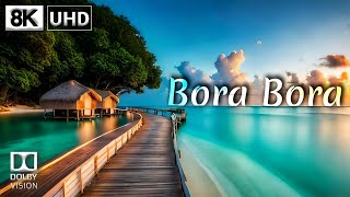
Bora Bora
Welcome to Bora Bora, a Tropical island in the South Pacific Ocean, part of the majestic Pacific Ocean. This guide offers a comprehensive overview of what makes Bora Bora unique – from its geography and climate to its population, infrastructure, and beyond. Dive into the details:
- Geography and Size: Explore the island’s size and location.
- Climate and Weather: Weather patterns and temperature.
- Topography and Nature: Uncover the natural wonders of the island.
- Infrastructure and Travelling: Insights on reaching, staying, and making the most of your visit.
- News and Headlines: Latest News.
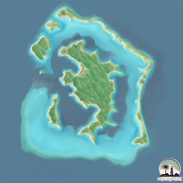
Geography and size of Bora Bora
Size: 19.5 km²
Coastline: 38.2 km
Ocean: Pacific Ocean
Sea: South Pacific Ocean
Continent: Oceania
Bora Bora is a Medium Island spanning 19 km² with a coastline of 38 km.
Archipel: Society Islands – A group of islands in the South Pacific Ocean, part of French Polynesia, famous for their idyllic beauty, including Tahiti and Bora Bora.
Tectonic Plate: Pacific – The world’s largest tectonic plate, covering much of the Pacific Ocean, known for the Pacific Ring of Fire with extensive seismic and volcanic activity.
The geographic heart of the island is pinpointed at these coordinates:
Latitude: -16.49858228 / Longitude: -151.73757501
Climate and weather of Bora Bora
Climate Zone: Tropical
Climate Details: Tropical Rainforest Climate
Temperature: Hot
Climate Characteristics: This climate is typified by heavy rainfall throughout the year, high humidity, and consistently high temperatures, leading to lush rainforests and rich biodiversity. Seasonal temperature variations are minimal.
Topography and nature of Bora Bora
Timezone: UTC-10:00
Timezone places: Pacific/Honolulu
Max. Elevation: 255 m
Mean Elevation: 78 m
Vegetation: Evergreen Broadleaf Forest
Tree Coverage: 59%
The mean elevation is 78 m. The highest elevation on the island reaches approximately 255 meters above sea level. The island is characterized by Hills: Gently sloping landforms with rounded tops, having a maximum elevation between 200 and 500 meters. Hills contribute to a varied landscape on islands.
Dominating Vegetation: Evergreen Broadleaf Forest
Characterized by dense, lush canopies of broadleaf trees that retain their leaves year-round. These forests are typically found in tropical and subtropical regions and are known for their high biodiversity. Bora Bora has a tree cover of 59 %.
Vegetation: 9 vegetation zones – Very Highly Diverse Island
Islands in this range are ecological powerhouses, showcasing a wide array of vegetation zones. Each zone, from lush rainforests to arid scrublands, coastal mangroves to mountainous regions, contributes to a complex and interdependent ecosystem. These islands are often hotspots of biodiversity, supporting numerous species and intricate ecological processes.
Infrastructure and Travelling to Bora Bora
Does the island have a public airport? no.
There is no public and scheduled airport on Bora Bora. The nearest airport is Bora Bora Airport, located 2 km away.
Does the island have a major port? yes.
Bora Bora is home to a major port. The following ports are situated on the island: VAITAPE.
The mean population of Bora Bora is 372 per km². Bora Bora is Moderately Inhabited. The island belongs to France.
The name of the island resonates across different cultures and languages. Here is how it is known around the world: Arabic: بورا بورا; German: Bora Bora; Spanish: Bora Bora; French: Bora-Bora; Portuguese: Bora Bora; Russian: Бора-Бора; Chinese: 博拉博拉岛
Continuing your journey, Taha’a is the next notable island, situated merely km away.
Top Places & Things To Do in Bora Bora - Travel Guide


France is classified as Developed region: G7: Group of Seven – Major advanced economies, including Canada, France, Germany, Italy, Japan, the United Kingdom, and the United States. The level of income is High income: OECD.
News – Latest Updates and Headlines from Bora Bora
Stay informed with the most recent news and important headlines from Bora Bora. Here’s a roundup of the latest developments.
Please note: The data used here has been primarily extracted from satellite readings. Deviations from exact values may occur, particularly regarding the height of elevations and population density. Land area and coastline measurements refer to average values at mean high tide.