Bouvetøya
Welcome to Bouvetøya, a Polar island in the South Atlantic Ocean, part of the majestic Atlantic Ocean. This guide offers a comprehensive overview of what makes Bouvetøya unique – from its geography and climate to its population, infrastructure, and beyond. Dive into the details:
- Geography and Size: Explore the island’s size and location.
- Climate and Weather: Weather patterns and temperature.
- Topography and Nature: Uncover the natural wonders of the island.
- Infrastructure and Travelling: Insights on reaching, staying, and making the most of your visit.
- News and Headlines: Latest News.
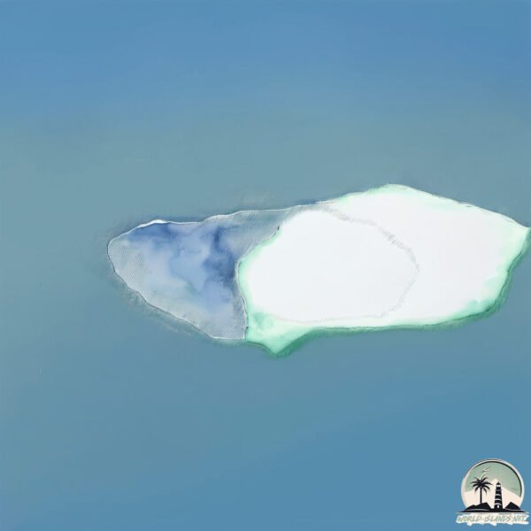
Geography and size of Bouvetøya
Size: 48.2 km²
Coastline: 29.5 km
Ocean: Atlantic Ocean
Sea: South Atlantic Ocean
Continent: Seven seas (open ocean)
Bouvetøya is a Medium Island spanning 48 km² with a coastline of 29 km.
Archipel: –
Tectonic Plate: Antarctica – Covers the Antarctic continent and extends outward, characterized by interactions with surrounding oceanic plates and known for its seismic activity along the periphery.
The geographic heart of the island is pinpointed at these coordinates:
Latitude: -54.42103086 / Longitude: 3.35907442
Climate and weather of Bouvetøya
Climate Zone: Polar
Climate Details: Tundra
Temperature: Cold
Climate Characteristics: The tundra climate features long, extremely cold winters and short, cool summers. Vegetation is limited to mosses, lichens, and small shrubs due to the low temperatures and short growing seasons. Biodiversity is low, but some specialized species thrive.
Topography and nature of Bouvetøya
Timezone: UTC+01:00
Timezone places: Europe/Paris
Max. Elevation: 652 m
Mean Elevation: 357 m
Vegetation: Snow and Ice Covered
Tree Coverage: 30%
The mean elevation is 357 m. The highest elevation on the island reaches approximately 652 meters above sea level. The island is characterized by Mountains: High, steeply elevated landforms. Characterized by both a high maximum elevation (over 500 meters) and a high mean elevation, creating rugged, mountainous terrains on islands.
Dominating Vegetation: Snow and Ice Covered
These areas are permanently or seasonally covered in snow and ice, with little to no vegetation, such as polar regions and high mountains. Bouvetøya has a tree cover of 30 %.
Vegetation: 8 vegetation zones – Very Highly Diverse Island
Islands in this range are ecological powerhouses, showcasing a wide array of vegetation zones. Each zone, from lush rainforests to arid scrublands, coastal mangroves to mountainous regions, contributes to a complex and interdependent ecosystem. These islands are often hotspots of biodiversity, supporting numerous species and intricate ecological processes.
Infrastructure and Travelling to Bouvetøya
Does the island have a public airport? no.
There is no public and scheduled airport on Bouvetøya. The nearest airport is Cape Town International Airport, located 2829 km away.
Does the island have a major port? no.
There are no major ports on Bouvetøya. The closest major port is EDINBURGH OF THE SEVEN SEAS, approximately 2592 km away.
The mean population of Bouvetøya is per km². Bouvetøya is . The island belongs to Norway.
The name of the island resonates across different cultures and languages. Here is how it is known around the world: Arabic: جزيرة بوفيه; German: Bouvetinsel; Spanish: Isla Bouvet; French: Île Bouvet; Portuguese: Ilha Bouvet; Russian: Остров Буве; Chinese: 布韦岛
Continuing your journey, Gough is the next notable island, situated merely km away.
The Most Remote Uninhabited Island in the World 📍 Bouvet Island 🏝️#map #geography #explanation


Norway is classified as Developed region: nonG7: Developed economies outside of the Group of Seven, characterized by high income and advanced economic structures. The level of income is High income: OECD.
News – Latest Updates and Headlines from Bouvetøya
Stay informed with the most recent news and important headlines from Bouvetøya. Here’s a roundup of the latest developments.
Please note: The data used here has been primarily extracted from satellite readings. Deviations from exact values may occur, particularly regarding the height of elevations and population density. Land area and coastline measurements refer to average values at mean high tide.