Brasil
Welcome to Brasil, a Dry island in the Caribbean Sea, part of the majestic Atlantic Ocean. This guide offers a comprehensive overview of what makes Brasil unique – from its geography and climate to its population, infrastructure, and beyond. Dive into the details:
- Geography and Size: Explore the island’s size and location.
- Climate and Weather: Weather patterns and temperature.
- Topography and Nature: Uncover the natural wonders of the island.
- Infrastructure and Travelling: Insights on reaching, staying, and making the most of your visit.
- News and Headlines: Latest News.
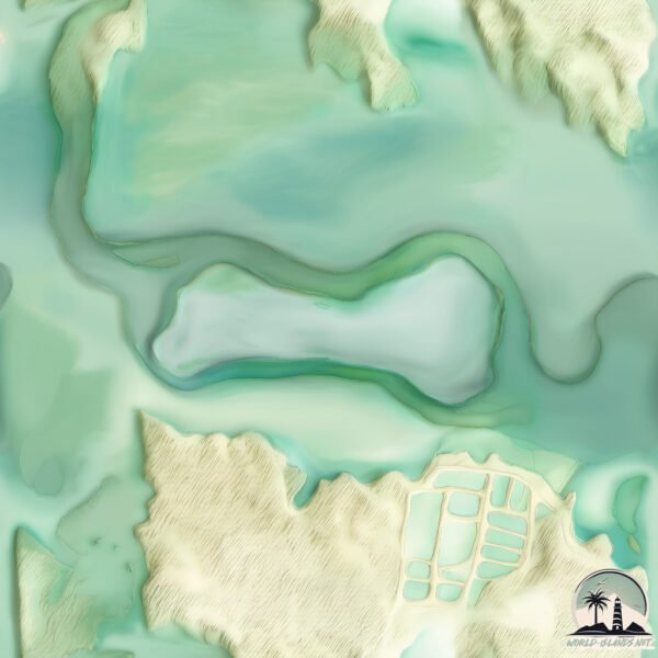
Geography and size of Brasil
Size: 2.282 km²
Coastline: 7.5 km
Ocean: Atlantic Ocean
Sea: Caribbean Sea
Continent: South America
Brasil is a Small Island spanning 2.3 km² with a coastline of 7.5 km.
Archipel: –
Tectonic Plate: Africa – One of the world’s largest tectonic plates, covering the African continent and parts of the surrounding oceans, known for its stability with some active rift zones.
The geographic heart of the island is pinpointed at these coordinates:
Latitude: 11.00277147 / Longitude: -71.83149886
Climate and weather of Brasil
Climate Zone: Dry
Climate Details: Hot Semi-Arid (Steppe) Climate
Temperature: Hot
Climate Characteristics: Features hot summers and mild to warm winters. Receives more rainfall than hot deserts but less than tropical savannas, leading to a somewhat more varied landscape.
Topography and nature of Brasil
Timezone: UTC-04:30
Timezone places: America/Caracas
Max. Elevation: 11 m
Mean Elevation: 10 m
Vegetation: Mangrove Forest
Tree Coverage: 80%
The mean elevation is 10 m. The highest elevation on the island reaches approximately 11 meters above sea level. The island is characterized by Plains: Flat, low-lying lands characterized by a maximum elevation of up to 200 meters. On islands, plains are typically coastal lowlands or central flat areas.
Dominating Vegetation: Mangrove Forest
Found in coastal areas and river deltas, these unique wetland ecosystems are adapted to saline conditions and are crucial for coastal protection and biodiversity. Brasil has a tree cover of 80 %.
Vegetation: 2 vegetation zones – Low Diversity Island
Islands with two distinct vegetation zones offer slightly more ecological variety. These zones could be due to differences in elevation, moisture, or other environmental factors. While still limited in biodiversity, these islands may offer a contrast between the two zones, such as a coastline with mangroves and an inland area with grassland.
Infrastructure and Travelling to Brasil
Does the island have a public airport? no.
There is no public and scheduled airport on Brasil. The nearest airport is La Chinita International Airport, located 50 km away.
Does the island have a major port? no.
There are no major ports on Brasil. The closest major port is PUNTA DE PALMAS, approximately 36 km away.
The mean population of Brasil is 88 per km². Brasil is Gently Populated. The island belongs to Venezuela.
Continuing your journey, Zapara is the next notable island, situated merely km away.
Lost Island of Hy-Brasil Located: The Atlantis of Ireland Discovered | Ancient Architects


Venezuela is classified as Emerging region: G20: Group of Twenty – Major economies comprising both developed and emerging countries, representing the world’s largest economies. The level of income is Upper middle income.
News – Latest Updates and Headlines from Brasil
Stay informed with the most recent news and important headlines from Brasil. Here’s a roundup of the latest developments.
Please note: The data used here has been primarily extracted from satellite readings. Deviations from exact values may occur, particularly regarding the height of elevations and population density. Land area and coastline measurements refer to average values at mean high tide.