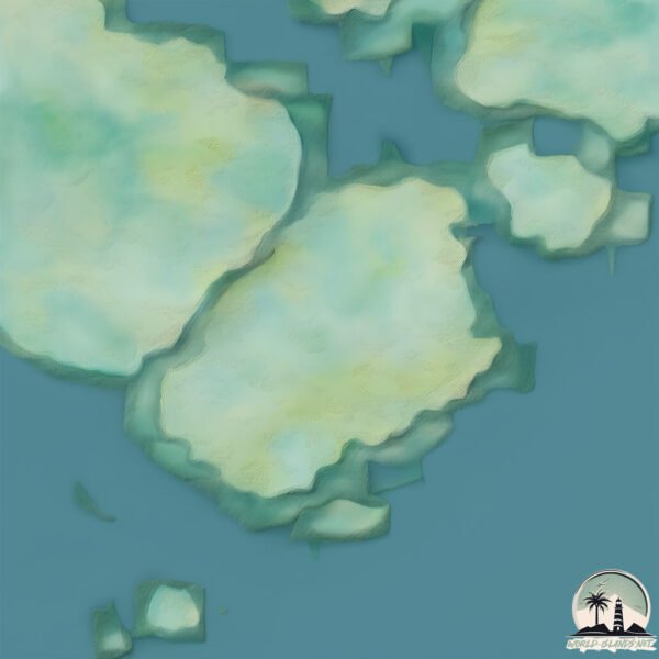
Welcome to Briand, a Polar island in the Indian Ocean, part of the majestic Indian Ocean. This guide offers a comprehensive overview of what makes Briand unique – from its geography and climate to its population, infrastructure, and beyond. Dive into the details:
Geography and size of Briand
Size: 1.729 km²
Coastline: 8.4 km
Ocean: Indian Ocean
Sea: Indian Ocean
Continent: Seven seas (open ocean)
Briand is a Small Island spanning 1.7 km² with a coastline of 8.4 km.
Archipel: Kerguelen Islands – A group of islands in the southern Indian Ocean, often referred to as the “Desolation Islands,” known for their isolation and harsh environment.
Tectonic Plate: Australia – A major tectonic plate covering Australia, New Zealand, and parts of the Indian and Pacific Oceans, known for its relative stability and occasional seismic activity.
The geographic heart of the island is pinpointed at these coordinates:
Latitude: -48.90715821 / Longitude: 69.43887018
Climate and weather of Briand
Climate Zone: Polar
Climate Details: Tundra
Temperature: Cold
Climate Characteristics: The tundra climate features long, extremely cold winters and short, cool summers. Vegetation is limited to mosses, lichens, and small shrubs due to the low temperatures and short growing seasons. Biodiversity is low, but some specialized species thrive.
Topography and nature of Briand
Timezone: UTC+05:00
Timezone places: Asia/Karachi
Max. Elevation: 23 m
Mean Elevation: 12 m
Vegetation: Evergreen Broadleaf Forest
Tree Coverage: 76%
The mean elevation is 12 m. The highest elevation on the island reaches approximately 23 meters above sea level. The island is characterized by Plains: Flat, low-lying lands characterized by a maximum elevation of up to 200 meters. On islands, plains are typically coastal lowlands or central flat areas.
Dominating Vegetation: Evergreen Broadleaf Forest
Characterized by dense, lush canopies of broadleaf trees that retain their leaves year-round. These forests are typically found in tropical and subtropical regions and are known for their high biodiversity. Briand has a tree cover of 76 %.
Vegetation: 3 vegetation zones – Moderately Diverse Island
These islands start to show a broader range of ecological niches. With three vegetation zones, they may offer a mix of ecosystems like coastal areas, inland woods, and perhaps a distinct wetland or dry area. This diversity supports a wider range of flora and fauna, making these islands more ecologically complex than those with minimal diversity.
Infrastructure and Travelling to Briand
Does the island have a public airport? no.
There is no public and scheduled airport on Briand. The nearest airport is Sir Charles Gaetan Duval Airport, located 3308 km away.
Does the island have a major port? no.
There are no major ports on Briand. The closest major port is PORT MATHURIN, approximately 3315 km away.
The mean population of Briand is per km². Briand is . The island belongs to Fr. S. Antarctic Lands.
Continuing your journey, Howe is the next notable island, situated merely km away.
Two-Bedroom Beach Villa Renovation COMPLETE | Renovation Island | HGTV
The Baeumlers balance construction on the villas and the watersports hut with creating an exceptional hotel guest experience.Two-Bedroom Beach Villa Renovation COMPLETE | Renovation Island | HGTV
The Baeumlers balance construction on the villas and the watersports ...
The Baeumlers balance construction on the villas and the watersports hut with creating an exceptional hotel guest experience.
The Truth About HGTV's Renovation Island
There are plenty of HGTV shows where contractors and designers will ...
There are plenty of HGTV shows where contractors and designers will flip houses, but Renovation Island sees husband and wife ...
HGTV "Renovation Island" Host & Pilot Bryan Baeumler
If you're not already an AOPA pilot, we'd love for you to join us. ...
If you're not already an AOPA pilot, we'd love for you to join us. Learn more about our FREE* trial membership!
Inside Beth Webb's Dreamy Brays Island Home
Step inside Atlanta-based designer Beth Webb's Brays Island retreat ...
Step inside Atlanta-based designer Beth Webb's Brays Island retreat that she shares with husband (and architect) Chuck ...
Bryan and Sarah Return to Canada to Recharge and Regroup | Renovation Island | HGTV
Tensions run high as Bryan and Sarah begin landscaping, and Sarah ...
Tensions run high as Bryan and Sarah begin landscaping, and Sarah reveals she needs a break from the build. On their one year ...
Did Bryan Baeumler Survive a Plane Crash? The Photos That Had Fans Worried #hgtv
Bryan Baeumler is a household name in the world of home renovation, ...
Bryan Baeumler is a household name in the world of home renovation, best known for his hit HGTV shows like Island of Bryan ...
NEW * Sealed With A Kiss - Brian Hyland {Stereo} 1962
1962....#3 U.S. Billboard Hot 100, #3 UK Singles Chart Original video ...
1962....#3 U.S. Billboard Hot 100, #3 UK Singles Chart Original video edited and AI remastered with HQ stereo sound. "Sealed ...
How Old Are Bryan and Sarah Baeumler’s Kids in 2024? Find Out What They’re Up To Now! #hgtv
How Old Are Bryan and Sarah Baeumler's Kids in 2024? Find Out What ...
How Old Are Bryan and Sarah Baeumler's Kids in 2024? Find Out What They're Up To Now! #hgtv.
Sealed with a Kiss (Remastered)
Provided to YouTube by Zebralution GmbH Sealed with a Kiss ...
Provided to YouTube by Zebralution GmbH Sealed with a Kiss (Remastered) · Brian Hyland His First Recordings ℗ 2020 Master ...
NEW 📀 Sealed With A Kiss - Brian Hyland {Stereo} 1962
1962....#3 U.S. Billboard Hot 100, #3 UK Singles Chart Original video ...
1962....#3 U.S. Billboard Hot 100, #3 UK Singles Chart Original video edited and remastered with HQ stereo sound. "Sealed with ...
We had an incredible couple of days at Brays Island Plantation!!
This Has To Be One Of The WORST GUYS In Reality TV History - Temptation Island Season 6 Review/Recap
Temptation Island recently came out with season 6 and it's absolutely ...
Temptation Island recently came out with season 6 and it's absolutely insane. We see temptation (of course), drama, lying, ...
Zach Bryan - Heading South
Rich Brian - Bumpy Road (feat. redveil)
Bumpy Road (feat. redveil)” from my third album “WHERE IS MY HEAD?” ...
Brian Hyland "Itsy Bitsy Teenie Weenie Yellow Polka Dot Bikini"
Saturday Night Beech-Nut Show. July 16, 1960. This has been re-posted ...
Saturday Night Beech-Nut Show. July 16, 1960. This has been re-posted by request.
This Dream Caribbean Villa on Richard Branson's Newest Island Is An 'Aerie' Oasis of Serenity
"The Aerie" one of just a handful of extraordinary estate homes on the ...
"The Aerie" one of just a handful of extraordinary estate homes on the private island of Moskito in the North Sound, British Virgin ...
Devil’s Island | Full Episode
An ex-Marine with a secret life and a secret wife. A five-year ...
An ex-Marine with a secret life and a secret wife. A five-year investigation turns on shocking DNA evidence — is the one-time hero ...
Family Guy: Road To The Multiverse (Clip) | TBS
Back before Walt Disney's Family Guy was a real thing, it was a fake ...
Back before Walt Disney's Family Guy was a real thing, it was a fake thing.” Seth Macfarlane on episode “Road to the Multiverse”.
HVOR MANGE GANGE KAN JEG KYSSE ANNA PÅ 24 TIMER! Challenge
Mange tak fordi du så med, synes det var en mega sjov video at lave! ...
Mange tak fordi du så med, synes det var en mega sjov video at lave! Hvis du godt kunne lide den, så glem ikke at like, subscribe ...
Bryan and Sarah Baeumler Reveals their Daughter Charlotte's Boyfriend.
Bryan and Sarah Baeumler are household names in the world of home ...
Bryan and Sarah Baeumler are household names in the world of home renovation television, especially through their popular ...
North Island New Zealand (GoPro) Brian D
This video is about My Movie.
This video is about My Movie.
'Brian's Hat' Full Sketch - I Think You Should Leave with Tim Robinson Season 2
Oh my God, did you see Brian's hat? Watch the full sketch of 'Brian's ...
Oh my God, did you see Brian's hat? Watch the full sketch of 'Brian's Hat' from Season 2, Episode 3 of 'I Think You Should Leave ...
daily life in the island car camping and surfing
Family Guy: Brian found his true love again
Sealed With A Kiss - Brian Hyland
Romance time with this melancholy love song from Brian Hyland, "Sealed ...
Romance time with this melancholy love song from Brian Hyland, "Sealed With A Kiss". Please like and share and subscribe to ...
Fr. S. Antarctic Lands is classified as Developed region: G7: Group of Seven – Major advanced economies, including Canada, France, Germany, Italy, Japan, the United Kingdom, and the United States. The level of income is High income: OECD.
News – Latest Updates and Headlines from Briand
Stay informed with the most recent news and important headlines from Briand. Here’s a roundup of the latest developments.
Loading...
Please note: The data used here has been primarily extracted from satellite readings. Deviations from exact values may occur, particularly regarding the height of elevations and population density. Land area and coastline measurements refer to average values at mean high tide.