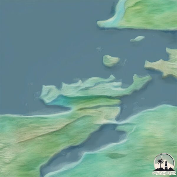
Welcome to Brottoya, a Continental island in the Norwegian Sea, part of the majestic Arctic Ocean. This guide offers a comprehensive overview of what makes Brottoya unique – from its geography and climate to its population, infrastructure, and beyond. Dive into the details:
Geography and size of Brottoya
Size: 3.096 km²
Coastline: 10.6 km
Ocean: Arctic Ocean
Sea: Norwegian Sea
Continent: Europe
Brottoya is a Small Island spanning 3.1 km² with a coastline of 10.6 km.
Archipel: –
Tectonic Plate: Eurasia – One of the world’s largest tectonic plates, the Eurasian Plate covers a significant portion of Europe and Asia. It’s characterized by diverse geological features, including the Ural Mountains, the European Plain, and the Himalayas formed from its collision with the Indian Plate.
The geographic heart of the island is pinpointed at these coordinates:
Latitude: 68.48332356 / Longitude: 15.16820294
Climate and weather of Brottoya
Climate Zone: Continental
Climate Details: Warm-Summer Humid Continental Climate
Temperature: Warm Summer
Climate Characteristics: Features warm summers and cold winters with consistent precipitation, common in higher latitudes.
Topography and nature of Brottoya
Timezone: UTC+01:00
Timezone places: Europe/Paris
Max. Elevation: 55 m
Mean Elevation: 48 m
Vegetation: Open Woodland
Tree Coverage: 57%
The mean elevation is 48 m. The highest elevation on the island reaches approximately 55 meters above sea level. The island is characterized by Plains: Flat, low-lying lands characterized by a maximum elevation of up to 200 meters. On islands, plains are typically coastal lowlands or central flat areas.
Dominating Vegetation: Open Woodland
Characterized by sparsely distributed trees with open canopy allowing sunlight to penetrate, supporting grasses and shrubs underneath. Often found in drier or transitional environments. Brottoya has a tree cover of 57 %.
Vegetation: 4 vegetation zones – Diverse Island
Four distinct vegetation zones mark these islands as ecologically diverse. They might feature varied landscapes such as forests, beaches, grasslands, and rocky areas. Such diversity reflects the island’s complex ecological interactions and varied habitats, which can support a rich array of wildlife and plant species.
Infrastructure and Travelling to Brottoya
Does the island have a public airport? no.
There is no public and scheduled airport on Brottoya. The nearest airport is Stokmarknes Airport, Skagen, located 15 km away.
Does the island have a major port? no.
There are no major ports on Brottoya. The closest major port is STOKKMARKNES, approximately 26 km away.
The mean population of Brottoya is 13 per km². Brottoya is Gently Populated. The island belongs to Norway.
The name of the island resonates across different cultures and languages. Here is how it is known around the world: Arabic: فيستريلان; German: Vesterålen; Spanish: Vesterålen; French: Vesterålen; Portuguese: Vesterålen; Russian: Вестеролен; Chinese: 西奧倫群島
Continuing your journey, Stormolla is the next notable island, situated merely km away.
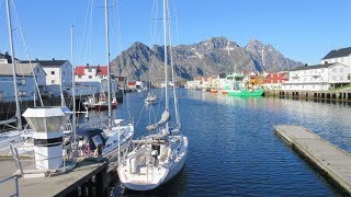
Tengelfjord, Norway's Lofoten Island Region
Enjoy some magnificent scenery along Norway's Tengelfjord as @ExploringWithSisters shares interesting facts about the Lofoten ...Tengelfjord, Norway's Lofoten Island Region
Enjoy some magnificent scenery along Norway's Tengelfjord as ...
Enjoy some magnificent scenery along Norway's Tengelfjord as @ExploringWithSisters shares interesting facts about the Lofoten ...
Drone Lofoten - North on Austvågøy, Lofoten, July 2022 - Delp, Grunnfør, Hadselsand, Morfjord - 4K
I took a trip from Laukvik through Gjersvoll, Delp, Grunnfør, ...
I took a trip from Laukvik through Gjersvoll, Delp, Grunnfør, Hadselsand and Morfjord on Austvågøy island in Lofoten with my ...
Full Rainbow on Austvågøya Island, one of the Loften Islands in Norway!
My time on the Loften Islands was simply unforgettable! Surrounded by ...
My time on the Loften Islands was simply unforgettable! Surrounded by stunning landscapes, I explored picturesque villages and ...
Norwegen Svolvaer
Svolvær? ist eine Stadt in Norwegen. Svolvær ist das ...
Svolvær? ist eine Stadt in Norwegen. Svolvær ist das Verwaltungszentrum der Kommune Vågan sowie die größte Stadt auf den ...
Austvågøy tour july 2021 - Henningsvær football field, Kabelvåg, Sildpollnes, Laukvik - 4K
Short drone video from around the Austvågøy island in Lofoten, Norway. ...
Short drone video from around the Austvågøy island in Lofoten, Norway. Includes Sildpollnes, Vestpollen, Kabelvåg, Laukvik and ...
Sunnlandsfjorden, Austvågøy in Lofoten by drone 4k
This video shows the area around Sunnlandsfjord and Blålyng in ...
This video shows the area around Sunnlandsfjord and Blålyng in Austvågøy island in Lofoten, a nice summer day in july 2019.
Sildpollnes - Austvågøy, Lofoten by drone 4k
This video shows the beautiful Sildpollnes, Austnesfjord and Vestpoll ...
This video shows the beautiful Sildpollnes, Austnesfjord and Vestpoll area in the Austvågøy island of Lofoten, Norway. Filmed by ...
Wild camping @Tengelfjord, Lofoten Islands Norway | Drone shot
Danny & Marus travel Tengelfjord (Raften), Lofoten Islands, Norway. ...
Danny & Marus travel Tengelfjord (Raften), Lofoten Islands, Norway. Great wild camping place in Norway. Bekijk ook: Norway ...
Exploring Svolvær - Lofoten Islands - Norway - Summer 2020 - Vlog
Svolvær is the administrative centre of Vågan Municipality in Nordland ...
Svolvær is the administrative centre of Vågan Municipality in Nordland County, Norway. It is located on the island of Austvågøya in ...
Lofoten - Vestvågøy & Austvågøy islands - Ballstad, Hauklandstranda, Henningsvaer, Svolvaer
Dramatic scenery of untouched nature and traditional fishing villages ...
Dramatic scenery of untouched nature and traditional fishing villages in Lofoten, Norwegian Arctic circle archipelago. #Norway ...
Travel Adventures - Austnesfjorden, Norway
In this Episode of Travel Adventures we do an Amazing hike... ...
In this Episode of Travel Adventures we do an Amazing hike... Austnesfjorden Norway ...
Lofoten Islands | Ep.1 | A road trip through Eastern Lofoten | Project Norway by CONTINENTRUNNER
Check out our road trip through Eastern Lofoten and the island ...
Check out our road trip through Eastern Lofoten and the island Austvågøy! In the span of 3 episodes, we are driving from Svolvær ...
Trip to Sortland @ Miles Henriksen
Sortland is a town and the administrative centre of Sortland ...
Sortland is a town and the administrative centre of Sortland Municipality in Nordland county, Norway. The town is located on the ...
At the Raftsund (norwegian fjord)
At the Raftsund (norwegian fjord) in the early days of March 2016.
At the Raftsund (norwegian fjord) in the early days of March 2016.
Svolvær is the administrative centre of Vågan Municipality in Nordland County, Norway.
Marciano Singson Travel Vlog Journey Around the World and Philippines ...
Marciano Singson Travel Vlog Journey Around the World and Philippines like: Svolvær is the administrative centre of Vågan ...
Norwegen Roadtrip 4/2022: Lofoten mit dem Camper, Wanderung Reinebringen und Digermulen, Tengelfjord
Andøya, eine Insel nördlich der Lofoten, ist definitiv eine Reise wert ...
Andøya, eine Insel nördlich der Lofoten, ist definitiv eine Reise wert und wir haben die Landschaft und die Zeit in unserem ...
Delp and Delpsmark in Austvågøy, Lofoten. Drone video. 4k
In this video you get a drone tour of flying over Delp, Grunnførfjord ...
In this video you get a drone tour of flying over Delp, Grunnførfjord and Delpsmark. Beautiful scenery from Austvågøy in Lofoten, ...
Hadsel: Øyplaner stoppet av naturvern
Join this channel to get access to perks: ...
Austvågøy island of Lofoten
Cinematic flight over a beautiful ridges and fjords of Austvågøy ...
Cinematic flight over a beautiful ridges and fjords of Austvågøy island (Lofoten, Norway) in ideally-artistic weather conditions.
Mitt Sortland
Her er en liten video med filmer fra 3 turer rundt i Sortland med ...
Her er en liten video med filmer fra 3 turer rundt i Sortland med modell-seilfly fra i sommer. De er alle tatt i løpet av noen flotte ...
Lofoten Henningsvær Vågan Lofoten Insel Austvågøya Norwegen Skandinavien Lofoten Islands Norway
Henningsvær ist ein Fischerdorf in der norwegischen Kommune Vågan, das ...
Henningsvær ist ein Fischerdorf in der norwegischen Kommune Vågan, das sich auf zwei kleinen, vorgelagerten Inseln vor der ...
Wild Norway: Lofoten Islands, Austvågøy – Kayaking, GoPro
Enjoy the beauty of nord Norway, Lofoten Islands. That was an amazing ...
Enjoy the beauty of nord Norway, Lofoten Islands. That was an amazing trip with +2 ... +7 °C in August. The best way to find your ...
Incredible evening sky from Austvågøya - Lofoten/Vesterålen
An impromptu live streaming of the evening sky seen from Austvågøy on ...
An impromptu live streaming of the evening sky seen from Austvågøy on the late evening of the 6th of july 2017. Austvågøy is the ...
Mountain of Steel! Stålberget, Hadsel’s 3rd Highest Peak
Join us on an epic hike to the “Mountain of Steel” — Stålberget! At ...
Join us on an epic hike to the “Mountain of Steel” — Stålberget! At 602 meters above sea level, this is Hadsel Island's third-highest ...
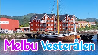
Melbu Hadsel in Vesterålen
Melbu# #Vesterålen# สวัสดีค่ะเพื่อนๆ ทุกคน วันนี้ช่อง ตุ๊กกี้ส์ Tuki`s ...
Melbu# #Vesterålen# สวัสดีค่ะเพื่อนๆ ทุกคน วันนี้ช่อง ตุ๊กกี้ส์ Tuki`s Channel จะพาเพื่อนๆ มาเที่ยว Melbu อยู่ในเทศบาล Hadsel ...
Norway is classified as Developed region: nonG7: Developed economies outside of the Group of Seven, characterized by high income and advanced economic structures. The level of income is High income: OECD.
News – Latest Updates and Headlines from Brottoya
Stay informed with the most recent news and important headlines from Brottoya. Here’s a roundup of the latest developments.
Loading...
Please note: The data used here has been primarily extracted from satellite readings. Deviations from exact values may occur, particularly regarding the height of elevations and population density. Land area and coastline measurements refer to average values at mean high tide.