Welcome to Bryher, a Temperate island in the Celtic Sea, part of the majestic Atlantic Ocean. This guide offers a comprehensive overview of what makes Bryher unique – from its geography and climate to its population, infrastructure, and beyond. Dive into the details:
Geography and size of Bryher
Size: 1.392 km²
Coastline: 10 km
Ocean: Atlantic Ocean
Sea: Celtic Sea
Continent: Europe
Bryher is a Small Island spanning 1.4 km² with a coastline of 10 km.
Archipel: –
Tectonic Plate: Eurasia – One of the world’s largest tectonic plates, the Eurasian Plate covers a significant portion of Europe and Asia. It’s characterized by diverse geological features, including the Ural Mountains, the European Plain, and the Himalayas formed from its collision with the Indian Plate.
The geographic heart of the island is pinpointed at these coordinates:
Latitude: 49.95383643 / Longitude: -6.35563589
Climate and weather of Bryher
Climate Zone: Temperate
Climate Details: Temperate Oceanic Climate
Temperature: Warm Summer
Climate Characteristics: Known for its moderate year-round temperatures with ample rainfall and no dry season. Warm summers are characteristic.
Topography and nature of Bryher
Timezone: UTC±00:00
Timezone places: Europe/London
Max. Elevation: 14 m
Mean Elevation: 10 m
Vegetation: Open Woodland
Tree Coverage: 53%
The mean elevation is 10 m. The highest elevation on the island reaches approximately 14 meters above sea level. The island is characterized by Plains: Flat, low-lying lands characterized by a maximum elevation of up to 200 meters. On islands, plains are typically coastal lowlands or central flat areas.
Dominating Vegetation: Open Woodland
Characterized by sparsely distributed trees with open canopy allowing sunlight to penetrate, supporting grasses and shrubs underneath. Often found in drier or transitional environments. Bryher has a tree cover of 53 %.
Vegetation: 4 vegetation zones – Diverse Island
Four distinct vegetation zones mark these islands as ecologically diverse. They might feature varied landscapes such as forests, beaches, grasslands, and rocky areas. Such diversity reflects the island’s complex ecological interactions and varied habitats, which can support a rich array of wildlife and plant species.
Infrastructure and Travelling to Bryher
Does the island have a public airport? no.
There is no public and scheduled airport on Bryher. The nearest airport is St. Mary’s Airport, located 7 km away.
Does the island have a major port? no.
There are no major ports on Bryher. The closest major port is ST. MARY’S (SCILLY ISL.), approximately 5 km away.
The mean population of Bryher is 54 per km². Bryher is Gently Populated. The island belongs to United Kingdom.
Continuing your journey, Île d’Ouessant is the next notable island, situated merely km away.
Isles of Scilly Bryher Island - Will Wagstaff Wildlife Tour + Rushy Bay Bryher
On our final full day of our Isles of Scilly holiday, for the final time we use the St Mary's Boatmen's Association to be transported ...Isles of Scilly Bryher Island - Will Wagstaff Wildlife Tour + Rushy Bay Bryher
On our final full day of our Isles of Scilly holiday, for the final ...
On our final full day of our Isles of Scilly holiday, for the final time we use the St Mary's Boatmen's Association to be transported ...
Bryher: An island of contrasts – Isles of Scilly Travel
Bryher has a bit of everything: a rugged, Atlantic side with dramatic ...
Bryher has a bit of everything: a rugged, Atlantic side with dramatic coastline and, occasionally, waves to match. But its sheltered ...
Day Trip To The Beautiful Island Of Bryher, Isles Of Scilly, Cornwall, UK
Another fantastic day trip to the Isles Of Scilly. This time we ...
Another fantastic day trip to the Isles Of Scilly. This time we visited the beautiful Island Of Bryher. We had 3 or so hours to explore ...
BRYHER - Isles of Scilly - Jonas Edmundo's Scilly Walks - EPISODE 3 / 5
JONAS DISCOVERS A LOAD OF COOL PLACES (& GUINNESS) AS HE WANDERS THE ...
JONAS DISCOVERS A LOAD OF COOL PLACES (& GUINNESS) AS HE WANDERS THE COASTAL PATHS ON BRYHER IN THE ...
Bonnie Bryher - Isles of Scilly
Bryher, Isles of Scilly
Bryher is one of the five inhabited islands on the Isles of Scilly. ...
Bryher is one of the five inhabited islands on the Isles of Scilly. Even though it is one of the smallest islands, it looks like all of the ...
A Look at Bryher, Isles of Scilly, UK.
A day trip to Bryher one of the inhabited 'off islands' of the Isles ...
ISLES of SCILLY - BEAUTIFUL ISLAND ESCAPE in the UK - vlog 2018
On this trip, we are island hopping in the crystal clear waters of the ...
On this trip, we are island hopping in the crystal clear waters of the Isles of Scilly. This archipelago looks like the Caribbean but is ...
Watch Hill, Bryher
Watch Hill is a hill on Bryher on the Isles of Scilly. It is above The ...
Watch Hill is a hill on Bryher on the Isles of Scilly. It is above The Town, the largest settlement on Bryher, and is the highest point ...
ISLES OF SCILLY TRAVEL GUIDE | Tresco, Bryher, St Marys, St Agnes, St Martins
Just 28 miles off the coast of Cornwall in southwest England you'll ...
Just 28 miles off the coast of Cornwall in southwest England you'll find a delightful paradise with white sand beaches, crystal clear ...
View Across The Isles Of Scilly From Bryher Island
A 360 degrees look across the Isles of Scilly during a windy Spring ...
A 360 degrees look across the Isles of Scilly during a windy Spring day from on top of a hill on Bryher Island.
Walking the Isles of Scilly: Bryher #islesofscilly #cornishcoast #hikingadventures #adventurewalks
We started our two island day getting the boat to Bryher. I loved this ...
We started our two island day getting the boat to Bryher. I loved this island with its Fudge, Succulents and a pub, right next to a ...
07/10/2021 Walking between the Islands of Tresco & Bryher, Isles of Scilly, UK, Low Tide Experience
This is a rare event where at the lowest tides you can walk between ...
This is a rare event where at the lowest tides you can walk between two of the islands on the Isles of Scilly, 28 miles off Cornwall, ...
Bryher, St Martins, St Agnes & Gugh and Tresco
This video is about Bryher, St Martins, St Agnes & Gugh and Tresco.
This video is about Bryher, St Martins, St Agnes & Gugh and Tresco.
Bryher, Isles of Scilly.
I visited Bryher, Isles of Scilly. It has stunning views plus ...
I visited Bryher, Isles of Scilly. It has stunning views plus Hangman's Rock with its noose and jib, Fraggle Rock bar, Veronica Farm ...
Bo Design featured on An Island Parish, BBC2, 2008
Here's a snippet of Bo Lemm from Bo Design and her then partner [now ...
Here's a snippet of Bo Lemm from Bo Design and her then partner [now husband] David Lemm, visiting artist Richard Pearce on ...
Great Rushy Bay, Bryher, Isles of Scilly #Scilly #Bryher
A beautiful day back on Bryher.
A beautiful day back on Bryher.
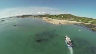
Isle Of Scilly from The Air. #islesofscilly #tresco #bryher #drone ©
An aerial view of Bryher and Tresco on the Isles Of Scilly. Strictly ...
An aerial view of Bryher and Tresco on the Isles Of Scilly. Strictly Rights Managed footage.
Isles of Scilly, Bryher
Bryher island, the Isles of Scilly. Located off the coast of Cornwall ...
Bryher island, the Isles of Scilly. Located off the coast of Cornwall Bryher is a rugged yet deeply beautiful island -- the perfect place ...
The beautiful island of Bryher, Isles of Scilly.
A gorgeous introduction to the home of the Hell Bay, Scilly's finest ...
A gorgeous introduction to the home of the Hell Bay, Scilly's finest hotel. The film was made by Gareth Tibbs, who lives at Samson ...
Island Hopping in the Isles of Scilly
How to see 3 islands in one day on the Isles of Scilly - a morning ...
How to see 3 islands in one day on the Isles of Scilly - a morning trip to Bryher, lunch on Tresco and afternoon ice cream on St ...
Hell Bay, Bryher, The Isles of Scilly
Music by Hawkwind.
Music by Hawkwind.
Picnic On The Beach - Bryher Island, Isles Of Scilly
Timelapse of our rather nice picnic on the beach with Sausage, Bacon ...
Timelapse of our rather nice picnic on the beach with Sausage, Bacon and Crab sandwiches swilled down with a drop of wine.
Plover Lover Friday Plove Island Episode 1 Bryher
On the stunning beaches of the Isles of Scilly many male plovers have ...
On the stunning beaches of the Isles of Scilly many male plovers have been puffing up their plumage in the hopes of captivating ...
Did you guess correctly?😮This is the Isles of Scilly! #travelbucketlist #travelblogger #uktravel
United Kingdom is classified as Developed region: G7: Group of Seven – Major advanced economies, including Canada, France, Germany, Italy, Japan, the United Kingdom, and the United States. The level of income is High income: OECD.
News – Latest Updates and Headlines from Bryher
Stay informed with the most recent news and important headlines from Bryher. Here’s a roundup of the latest developments.
Loading...
Please note: The data used here has been primarily extracted from satellite readings. Deviations from exact values may occur, particularly regarding the height of elevations and population density. Land area and coastline measurements refer to average values at mean high tide.