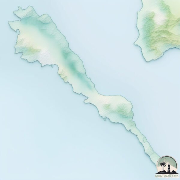
Welcome to Burias, a Tropical island in the Philippine Sea, part of the majestic Pacific Ocean. This guide offers a comprehensive overview of what makes Burias unique – from its geography and climate to its population, infrastructure, and beyond. Dive into the details:
Geography and size of Burias
Size: 419.4 km²
Coastline: 233.2 km
Ocean: Pacific Ocean
Sea: Philippine Sea
Continent: Asia
Burias is a Large Island spanning 419 km² with a coastline of 233 km.
Archipel: Malay Archipelago – The world’s largest archipelago, located between mainland Southeast Asia and Australia, known for its immense biodiversity and cultural diversity.
Tectonic Plate: Sunda – Extends across Southeast Asia, encompassing parts of the Sunda Shelf, known for its interaction with the Australian Plate, contributing to volcanic activity in Indonesia.
The geographic heart of the island is pinpointed at these coordinates:
Latitude: 12.97717116 / Longitude: 123.11025792
Climate and weather of Burias
Climate Zone: Tropical
Climate Details: Tropical Rainforest Climate
Temperature: Hot
Climate Characteristics: This climate is typified by heavy rainfall throughout the year, high humidity, and consistently high temperatures, leading to lush rainforests and rich biodiversity. Seasonal temperature variations are minimal.
Topography and nature of Burias
Timezone: UTC+08:00
Timezone places: Australia/Perth
Max. Elevation: 356 m
Mean Elevation: 68 m
Vegetation: Agricultural Mosaic
Tree Coverage: 43%
The mean elevation is 68 m. The highest elevation on the island reaches approximately 356 meters above sea level. The island is characterized by Hills: Gently sloping landforms with rounded tops, having a maximum elevation between 200 and 500 meters. Hills contribute to a varied landscape on islands.
Dominating Vegetation: Agricultural Mosaic
A mix of cropland and natural vegetation, often seen in rural landscapes where agricultural fields are interspersed with patches of natural habitats. Burias has a tree cover of 43 %.
Vegetation: 13 vegetation zones – Exceptionally Diverse Island
Islands with more than ten vegetation zones are among the most ecologically rich and varied in the world. These islands are akin to miniature continents, boasting an incredible array of ecosystems. The sheer range of habitats, from high peaks to deep valleys, rainforests to deserts, creates a mosaic of life that is unparalleled. They are crucial for conservation and ecological studies.
Infrastructure and Travelling to Burias
Does the island have a public airport? no.
There is no public and scheduled airport on Burias. The nearest airport is Moises R. Espinosa Airport, located 45 km away.
Does the island have a major port? no.
There are no major ports on Burias. The closest major port is MASBATE, approximately 45 km away.
The mean population of Burias is 231 per km². Burias is Moderately Inhabited. The island belongs to Philippines.
Continuing your journey, Ticao is the next notable island, situated merely km away.
BURIAS ISLAND, Masbate: Exploring Tourist Attractions in San Pascual
Burias Island, one of the three major islands of the province of Masbate. It is composed of two municipalities: Claveria and San ...BURIAS ISLAND, Masbate: Exploring Tourist Attractions in San Pascual
Burias Island, one of the three major islands of the province of ...
Burias Island, one of the three major islands of the province of Masbate. It is composed of two municipalities: Claveria and San ...
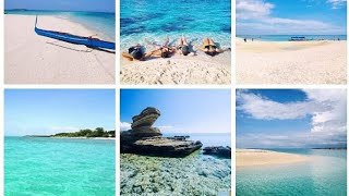
Island Hopping at Burias Group of Islands, Masbate, Philippines #travel #travelph
Embark on an unforgettable island hopping adventure through the ...
Embark on an unforgettable island hopping adventure through the pristine waters of the Burias Group of Islands in the Philippines, ...
Brgy, San isidro (CLAVERIA, MASBATE) Burias Island
Burias Island #philippines #buriasisland #youtubeshorts #trendingnow #trending #trendingshorts
TARA IKOTIN NATIN ANG SAN PASCUAL MASBATE BURIAS ISLAND(BAYAN)
TARA IKOTIN NATIN SAN PASCUAL MASBATE BURIAS ISLAND(BAYAN) ...
TARA IKOTIN NATIN SAN PASCUAL MASBATE BURIAS ISLAND(BAYAN) #BURIASISLAND#KUYANOLIVLOG.
Burias Island, masbate philippines
Masbate | Best Beaches of Burias Island | Lost Juan
Nagsimula na ang Summer sa Pinas kaya naman narito ang isa sa mga bago ...
Nagsimula na ang Summer sa Pinas kaya naman narito ang isa sa mga bago ng destinasyon na pwede mong puntahan.
Brgy. Nonoc (Claveria, Masbate) Burias Island
Claveria, Masbate Burias Island
Bangkang sinakyan ng 20 turista papuntang Burias Island, Masbate, nagkaaberya
Bandang alas-8:40 ng umaga nitong Sabado ng nakaalis ang bangkang ...
Bandang alas-8:40 ng umaga nitong Sabado ng nakaalis ang bangkang Harlyn 1 mula San Andres Port, Burias Island, Masbate ...
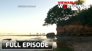
Discover the beauty of serenity in Burias Island (Stream Together) | Biyahe ni Drew
Aired (February 29, 2016): Join Biyahero Drew as he explores the ...
Aired (February 29, 2016): Join Biyahero Drew as he explores the unexplored treasures of Burias Island in Masbate - where ...
Famous Rock Formation in Burias Island Philippines || Jenny Irish GK
Burias Island Philippines || Jenny Irish GK
BUDGET FRIENDLY GUIDE BURIAS ISLAND SAN PASCUAL MASBATE 2DAYS AND 1NIGHT #buriasisland
sombreroisland #buriasisland #aminasolaisland #whitesbeach ...
sombreroisland #buriasisland #aminasolaisland #whitesbeach #wheninmasbate #summer #summervibes #summertime ...
Sombrero Island, San Pascual, Burias Island, Masbate. #beach #beachshorts #travel
Sombrero Island, San Pascual, Burias Island, Masbate.
Sombrero Island, San Pascual, Burias Island, Masbate.
BURIAS ISLAND | CINEMATIC DRONE VIDEO | 📍PUNTALINAO BANAYBANAY DAVAO ORIENTAL
BURIAS ISLAND NG BANAYBANAY.
BURIAS ISLAND NG BANAYBANAY.
FULL EPISODE: 'Biyahe ni Drew' in Burias Island, Masbate
Isang laidback lifestyle ang handog ng Burias Island sa Masbate. (Date ...
Isang laidback lifestyle ang handog ng Burias Island sa Masbate. (Date aired: February 26, 2016) Subscribe to the GMA News ...
BURIAS ISLAND, SAN PASCUAL, MASBATE - INFOMERCIAL
Final Requirement in Readings in Philippine History Presented by: ...
Final Requirement in Readings in Philippine History Presented by: Polytechnic University of the Philippines Sta. Mesa, Manila ...
Island hopping at seafood foodtrip, mae-enjoy sa Burias island sa Masbate | 24 Oras
Road to Bicolandia muli tayo! At ang ating next stop, ang tinaguriang ...
Road to Bicolandia muli tayo! At ang ating next stop, ang tinaguriang "Rodeo Capital of the Philippines", ang Masbate! May mga ...
BURIAS ISLAND MASBATE (Short Clip) 2017 | FIRST VLOG | BEA BALAIS
Hi! Welcome to my Channel. I'm Bea Balais and I've love doing TV ...
Hi! Welcome to my Channel. I'm Bea Balais and I've love doing TV (travel vids). Burias Island is one of the three major islands of ...
Burias Island, Masbate's very own hidden gem!
After a two-month hiatus we're back and continuing on with our ...
After a two-month hiatus we're back and continuing on with our adventures, bringing you ti the best vacation spots in the ...
"Burias Island's Hidden Paradise 🌴+ Secret Islands You’ve Never Seen!"#paradisephilippines#adventure
San Pascual Port - Going to Burias Island - The Philippines
Please watch: "Bungee Jumping from Hong Kong Sky Scraper #shorts" ...
Finding the Perfect Stay in Burias Island, Masbate + Road Trip | Masbate Vlog Ep 2 | Dhang & Marie
We're Dhang and Marie, and this Masbate travel adventure is as real as ...
We're Dhang and Marie, and this Masbate travel adventure is as real as it gets. In this Masbate vlog, we take you on a DIY travel ...
Philippines is classified as Emerging region: G20: Group of Twenty – Major economies comprising both developed and emerging countries, representing the world’s largest economies. The level of income is Lower middle income.
News – Latest Updates and Headlines from Burias
Stay informed with the most recent news and important headlines from Burias. Here’s a roundup of the latest developments.
Loading...
Please note: The data used here has been primarily extracted from satellite readings. Deviations from exact values may occur, particularly regarding the height of elevations and population density. Land area and coastline measurements refer to average values at mean high tide.