Welcome to Cangrejo, a Tropical island in the North Pacific Ocean, part of the majestic Pacific Ocean. This guide offers a comprehensive overview of what makes Cangrejo unique – from its geography and climate to its population, infrastructure, and beyond. Dive into the details:
Geography and size of Cangrejo
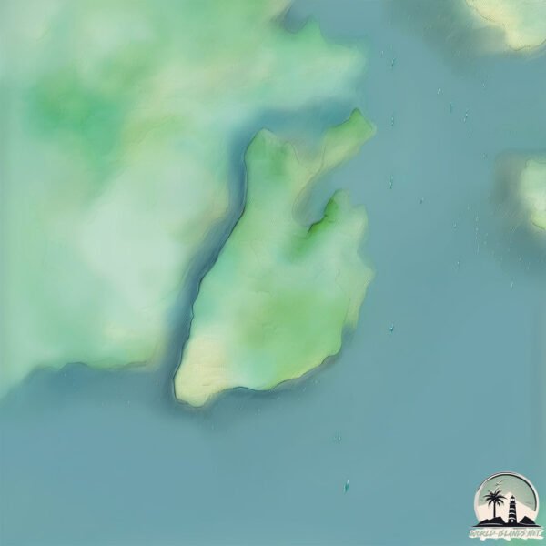
Size: 2.798 km²
Coastline: 10.5 km
Ocean: Pacific Ocean
Sea: North Pacific Ocean
Continent: South America
Cangrejo is a Small Island spanning 2.8 km² with a coastline of 10.5 km.
Archipel: –
Tectonic Plate: North Andes – Located in South America, covering Colombia, Ecuador, and part of Venezuela, it is known for its seismic activity due to interactions with the South American Plate.
The geographic heart of the island is pinpointed at these coordinates:
Latitude: 3.88195941 / Longitude: -77.10223745
Climate and weather of Cangrejo
Climate Zone: Tropical
Climate Details: Tropical Rainforest Climate
Temperature: Hot
Climate Characteristics: This climate is typified by heavy rainfall throughout the year, high humidity, and consistently high temperatures, leading to lush rainforests and rich biodiversity. Seasonal temperature variations are minimal.
Topography and nature of Cangrejo
Timezone: UTC-05:00
Timezone places: America/New_York
Max. Elevation: 12 m
Mean Elevation: 7 m
Vegetation: Mangrove Forest
Tree Coverage: 64%
The mean elevation is 7 m. The highest elevation on the island reaches approximately 12 meters above sea level. The island is characterized by Plains: Flat, low-lying lands characterized by a maximum elevation of up to 200 meters. On islands, plains are typically coastal lowlands or central flat areas.
Dominating Vegetation: Mangrove Forest
Found in coastal areas and river deltas, these unique wetland ecosystems are adapted to saline conditions and are crucial for coastal protection and biodiversity. Cangrejo has a tree cover of 64 %.
Vegetation: 3 vegetation zones – Moderately Diverse Island
These islands start to show a broader range of ecological niches. With three vegetation zones, they may offer a mix of ecosystems like coastal areas, inland woods, and perhaps a distinct wetland or dry area. This diversity supports a wider range of flora and fauna, making these islands more ecologically complex than those with minimal diversity.
Infrastructure and Travelling to Cangrejo
Does the island have a public airport? no.
There is no public and scheduled airport on Cangrejo. The nearest airport is Gerardo Tobar López Airport, located 13 km away.
Does the island have a major port? no.
There are no major ports on Cangrejo. The closest major port is BUENAVENTURA, approximately 3 km away.
The mean population of Cangrejo is 84 per km². Cangrejo is Gently Populated. The island belongs to Colombia.
Continuing your journey, Soldado is the next notable island, situated merely km away.
Surviving On Giant Crab Island Using A Hand Spear
Surviving on whatever I can catch as we search for the world's largest land crab which takes us on a wild adventure through this ...Surviving On Giant Crab Island Using A Hand Spear
Surviving on whatever I can catch as we search for the world's largest ...
Surviving on whatever I can catch as we search for the world's largest land crab which takes us on a wild adventure through this ...
GIANT CRABS rule this Island
The Story Behind the Red Crab Migration on Christmas Island
You may have seen the viral images of millions of red crabs shutting ...
You may have seen the viral images of millions of red crabs shutting down roads as they crawl across Australia's Christmas Island ...
Crab Island in Destin, Florida
Welcome to the beautiful Crab Island! If you've ever made the trip to ...
Welcome to the beautiful Crab Island! If you've ever made the trip to the Emerald Coast, Destin specifically, there's a great chance ...
Perilous Red Crab Migration | Incredible Animal Journeys | National Geographic
Red crabs begin their march to the sea, overcoming predators and ...
Red crabs begin their march to the sea, overcoming predators and threats to lay their eggs. Enjoy a free trial of National ...
100 Million Red Crabs On A Tropical Island - Biggest Crab Migration In The World
The biggest crab migration in the world happens only on this remote ...
The biggest crab migration in the world happens only on this remote tropical island! Over 100 million crabs will make the shore ...
A floating playground: Destin's Crab Island
DESTIN, Fla. -- It's not really an island — but on a spring break day ...
DESTIN, Fla. -- It's not really an island — but on a spring break day in Destin, Crab Island is exactly where people want to be.
Crab Island, Destin Florida
Noisestorm - Crab Rave [Monstercat Release]
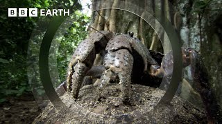
The Colossal Coconut Crab | South Pacific | BBC Earth
These giant crabs, also known as robber crabs, live in huge numbers on ...
These giant crabs, also known as robber crabs, live in huge numbers on islands in the South Pacific. But since they can't swim, we ...
Gigantic Robber Crabs on Christmas Island | Full Documentary
Thievery and treachery are second nature for the world's largest land ...
Thievery and treachery are second nature for the world's largest land crab. This documentary explores the untold story of ...
Watch the Christmas Island red crab migration
Every year, millions of red crabs make their migration to the Indian ...
Every year, millions of red crabs make their migration to the Indian Ocean from Australia's Christmas Island to breed. #animals ...
GIANT MUDCRAB barehanded catch for ISLAND SURVIVAL
The biggest mudcrab we have ever seen! Watch the full Episode: ...
Island Survival Only Using My Bare Hands To Catch Food
You won't believe the size of the crabs we caught.. YBS PRODUCTS - ...
The Tragic Journey of Christmas Island Crabs || #facts #animals
Wildlife: Animal migration, rare wildlife, jungle life, nature ...
Wildlife: Animal migration, rare wildlife, jungle life, nature documentary, ecosystem balance Every year, millions of red crabs ...
Millions of red crabs take over Australian island in annual spectacle
Millions of red crabs have taken over an Australian island in their ...
Millions of red crabs have taken over an Australian island in their annual migration spectacle. The parade of crustaceans can be ...
Destin’s Crab Island #Destin #Florida #CrabIsland
The LARGEST Crabs in the WORLD! 🦀
The Island of the Crab (La Isla del Cangrejo - Crab Island) - Complete movie in English 2000
The movie "The Island of the Crab (La Isla del Cangrejo - Crab ...
The movie "The Island of the Crab (La Isla del Cangrejo - Crab Island)" distributed on DVD by Filmax Home Video in 2001.
Charco de isla Cangrejo
Piscina natural en Acantilado de los Gigantes (TENERIFE)
Piscina natural en Acantilado de los Gigantes (TENERIFE)
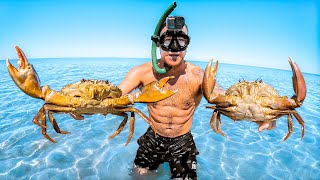
Catching A Giant Crab For Food With Bare Hands
Surviving on a remote, tropical island only catching my food with my ...
Surviving on a remote, tropical island only catching my food with my hands, like a big coconut crab. Thank you to Costa and ...
Tenerife - Los Gigantes, charco de Isla Cangrejo 🦀🏊♂️🌊 #canaritainfo #tenerife #losgigantes
Huge Coconut Crab!! 🦀 (UNLIKE Any Other Crab on Earth!!) South Pacific Islands
Crab Island In Destin, Florida, USA!!!
Crab Island In Destin, Florida, USA!!!
Crab Island In Destin, Florida, USA!!!
Colombia is classified as Developing region: Regions characterized by lower income levels, with economies in the process of industrialization and modernization. The level of income is Upper middle income.
News – Latest Updates and Headlines from Cangrejo
Stay informed with the most recent news and important headlines from Cangrejo. Here’s a roundup of the latest developments.
Loading...
Please note: The data used here has been primarily extracted from satellite readings. Deviations from exact values may occur, particularly regarding the height of elevations and population density. Land area and coastline measurements refer to average values at mean high tide.


![Noisestorm - Crab Rave [Monstercat Release]](https://i.ytimg.com/vi/LDU_Txk06tM/mqdefault.jpg)