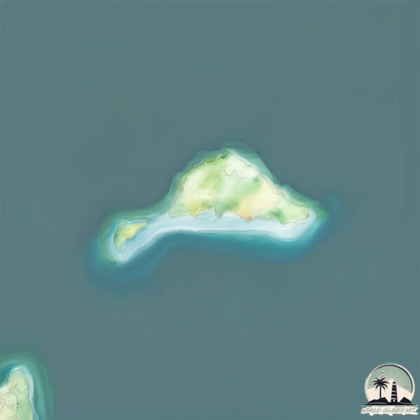
Welcome to Canning Island, a Temperate island in the Great Australian Bight, part of the majestic Indian Ocean. This guide offers a comprehensive overview of what makes Canning Island unique – from its geography and climate to its population, infrastructure, and beyond. Dive into the details:
Geography and size of Canning Island
Size: 0.101 km²
Coastline: 1.8 km
Ocean: Indian Ocean
Sea: Great Australian Bight
Continent: Oceania
Canning Island is a Tiny Island spanning 0.101 km² with a coastline of 1.8 km.
Archipel: –
Tectonic Plate: Australia – A major tectonic plate covering Australia, New Zealand, and parts of the Indian and Pacific Oceans, known for its relative stability and occasional seismic activity.
The geographic heart of the island is pinpointed at these coordinates:
Latitude: -33.91729894 / Longitude: 121.7730807
Climate and weather of Canning Island
Climate Zone: Temperate
Climate Details: Warm-Summer Mediterranean Climate
Temperature: Warm Summer
Climate Characteristics: Characterized by warm, dry summers and mild, wet winters, typical of coastal areas with abundant sunshine Rain is more common in the winter months, maintaining a moderate climate.
Topography and nature of Canning Island
Timezone: UTC+08:00
Timezone places: Australia/Perth
Max. Elevation: -4 m
Mean Elevation: -9 m
Vegetation: Evergreen Needleleaf Forest
Tree Coverage: 91%
The mean elevation is -9 m. Remarkably, this unique island barely emerges above the sea level, showcasing nature’s fascinating interplay with the ocean. The island is characterized by Plains: Flat, low-lying lands characterized by a maximum elevation of up to 200 meters. On islands, plains are typically coastal lowlands or central flat areas.
Dominating Vegetation: Evergreen Needleleaf Forest
Dominated by evergreen coniferous trees such as pines and firs, which retain their needle-like leaves throughout the year. These forests are often found in cooler climates. Canning Island has a tree cover of 91 %.
Vegetation: 1 vegetation zones – Minimal Diversity Island
These islands exhibit the most basic level of ecological diversity, often characterized by a single dominant vegetation type. This could be due to extreme environmental conditions, limited land area, or significant human impact. They represent unique ecosystems where specific species have adapted to thrive in these singular environments.
Infrastructure and Travelling to Canning Island
Does the island have a public airport? no.
There is no public and scheduled airport on Canning Island. The nearest airport is Esperance Airport, located 26 km away.
Does the island have a major port? no.
There are no major ports on Canning Island. The closest major port is ESPERANCE, approximately 15 km away.
The mean population of Canning Island is 0 per km². Canning Island is Uninhabited. The island belongs to Australia.
Continuing your journey, Garden is the next notable island, situated merely km away.
~Canning Rum Island Butter~
It's a tropical vacation in a jar! No . . . it's "BOB MARLEY" in a jar! It's taking peanut butter sandwiches to a whole new level.~Canning Rum Island Butter~
It's a tropical vacation in a jar! No . . . it's "BOB MARLEY" in a ...
It's a tropical vacation in a jar! No . . . it's "BOB MARLEY" in a jar! It's taking peanut butter sandwiches to a whole new level.
City Island, Canning Town
Cycleway Recorded September 2022.
Cycleway Recorded September 2022.
Brand New 1 Bedroom to rent London City Island Canning Town with Pool, Gym, Jacuzzi
Defoe House, London City Island 123 City Island Way E14 0TU - Brand ...
Defoe House, London City Island 123 City Island Way E14 0TU - Brand New Apartment, just completed Please advise if you are ...
London City Island (Canning Town) : 提供1 3 房河畔公寓新地標
London City Island (Canning Town) 倫敦島嶼生活社區,毗鄰國際金融中心Canary Wharf ...
London City Island (Canning Town) 倫敦島嶼生活社區,毗鄰國際金融中心Canary Wharf (金絲雀碼頭) 步行2分鐘到Canning ...
Nehit Canned Videos: North Sentinel Island
Just an effort to entertain you with the trends.
Just an effort to entertain you with the trends.
New island In Canning || New Travel Destination In Canning || Adventure Trip In Canning River ||
New island In Canning || New Travel Destination In Canning || ...
New island In Canning || New Travel Destination In Canning || Adventure Trip In Canning River || Yesterday we went Canning ...
best LONDON ISLAND LONDON NIGHTLIFE EID PARTY velly of CANNING TOWN
LONDON ISLAND LONDON NIGHTLIFE EID PARTY velly of CANNING TOWN.
LONDON ISLAND LONDON NIGHTLIFE EID PARTY velly of CANNING TOWN.
1. Canning Town - view from City Island to Brunel Street Works
This view clearly shows the existing Brunel Street Works buildings, ...
This view clearly shows the existing Brunel Street Works buildings, across Bow Creek.
The canning class was a success!Music cred: Music: Island Joy Musician: David Godfrey
A Night On A Deserted Island With Only Canned Potatoes And A $13 Kmart Tent 🫣 (Didn’t End Well)
In true Soph and Chris style we decided the day before to find this ...
In true Soph and Chris style we decided the day before to find this location only accessible by boat and attempt to camp a night.
Bow creek island through the Canning Town station. Very beautiful view. London. #goviral #england
How to Survive on a Deserted Island
LONDON ISLAND ep 2 - THE HOMELESS LONDONERS outside Canning Town BEAUTIFUL APARTMENTS
The Homeless living under the bridge in the best transforming ...
The Homeless living under the bridge in the best transforming neighbourhood of Canning Town of east London. London Island ...
Canning Conveyor - Sports Relief 2020 with Blue Peter and Love Island Winners
For more information about our what we provide to the film, TV and ...
For more information about our what we provide to the film, TV and entertainment industry contact ...
Ultraconvenient 2-Bedroom Flat for Rent | City Island Way, Canning Town, E14 | RentLondonFlat.com
Brand new and spacious two-bedroom apartment with wonderful balcony ...
Brand new and spacious two-bedroom apartment with wonderful balcony overlooking the River Thames, set on the 11th floor in ...
2 bedroom(s) City Island Way, Canning town, E14 | Benham & Reeves
This modern apartment is set in Corson House, close to the floor ...
This modern apartment is set in Corson House, close to the floor bridge for the Jubilee line, part of the London City Island ...
Island Beer Club Volunteers for Canning Operation
Members of Coronado's Island Beer Club surprised Attitude Brewery ...
Members of Coronado's Island Beer Club surprised Attitude Brewery owner Kurt Bach by volunteering to operate the machinery ...
Kiawah Island organizes canned food drive
The CW News at 10pm.
The CW News at 10pm.
Canning Prep
Wash jars to sanitize them Boil water in a canning pot – ensure there ...
Wash jars to sanitize them Boil water in a canning pot – ensure there is enough water for jars to be fully submerged Boil lids in a ...
Canning the Chanterelle Harvest from Foraging during Hunting on Vancouver Island
I was blessed with a bounty of Chanterelle Mushrooms which I foraged ...
I was blessed with a bounty of Chanterelle Mushrooms which I foraged while out hunting. This video shows the process I do to ...
The Red Bridge | London city island |Canning town foot bridge | Beautiful place in London|Nice place
Hi all today I will share an amazing place of London which is located ...
Hi all today I will share an amazing place of London which is located in Canning town near the Canning town station. It is known ...
2. Canning Town - view from City Island to Brunel Street Works
This view is across Bow Creeek to the site. You can clearly see the ...
This view is across Bow Creeek to the site. You can clearly see the Limmo Peninsula to the front and the Brunel Street Works ...
Flying over a salmon canning facility on Kodiak Island
City 🏙 Island, Canning Town, London. #cityisland #canningtown #londonlifestyle #travel #travel
Australia is classified as Developed region: nonG7: Developed economies outside of the Group of Seven, characterized by high income and advanced economic structures. The level of income is High income: OECD.
News – Latest Updates and Headlines from Canning Island
Stay informed with the most recent news and important headlines from Canning Island. Here’s a roundup of the latest developments.
Loading...
Please note: The data used here has been primarily extracted from satellite readings. Deviations from exact values may occur, particularly regarding the height of elevations and population density. Land area and coastline measurements refer to average values at mean high tide.