Welcome to Canoe, a Polar island in the Beaufort Sea, part of the majestic Arctic Ocean. This guide offers a comprehensive overview of what makes Canoe unique – from its geography and climate to its population, infrastructure, and beyond. Dive into the details:
Geography and size of Canoe
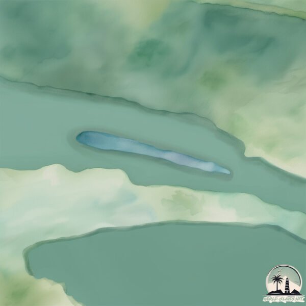
Size: 0.182 km²
Coastline: 2.7 km
Ocean: Arctic Ocean
Sea: Beaufort Sea
Continent: North America
Canoe is a Tiny Island spanning 0.182 km² with a coastline of 2.7 km.
Archipel: –
Tectonic Plate: North America – Covers North America and parts of the Atlantic and Arctic Oceans, characterized by diverse geological features and varying levels of seismic activity.
The geographic heart of the island is pinpointed at these coordinates:
Latitude: 69.67692393 / Longitude: -129.01358418
Climate and weather of Canoe
Climate Zone: Polar
Climate Details: Tundra
Temperature: Cold
Climate Characteristics: The tundra climate features long, extremely cold winters and short, cool summers. Vegetation is limited to mosses, lichens, and small shrubs due to the low temperatures and short growing seasons. Biodiversity is low, but some specialized species thrive.
Topography and nature of Canoe
Timezone: UTC-07:00
Timezone places: America/Denver
Max. Elevation: -9 m
Mean Elevation: -9 m
Vegetation: Herbaceous Cover
Tree Coverage: 76%
The mean elevation is -9 m. Remarkably, this unique island barely emerges above the sea level, showcasing nature’s fascinating interplay with the ocean. The island is characterized by Plains: Flat, low-lying lands characterized by a maximum elevation of up to 200 meters. On islands, plains are typically coastal lowlands or central flat areas.
Dominating Vegetation: Herbaceous Cover
Comprising mainly of grasses, herbs, and ferns, these areas are common in prairies, meadows, and savannas, and can vary widely in species composition. Canoe has a tree cover of 76 %.
Vegetation: 1 vegetation zones – Minimal Diversity Island
These islands exhibit the most basic level of ecological diversity, often characterized by a single dominant vegetation type. This could be due to extreme environmental conditions, limited land area, or significant human impact. They represent unique ecosystems where specific species have adapted to thrive in these singular environments.
Infrastructure and Travelling to Canoe
Does the island have a public airport? no.
There is no public and scheduled airport on Canoe. The nearest airport is Fort Good Hope Airport, located 383 km away.
Does the island have a major port? no.
There are no major ports on Canoe. The closest major port is TUKTOYAKTUK, approximately 442 km away.
The mean population of Canoe is 0 per km². Canoe is Uninhabited. The island belongs to Canada.
Continuing your journey, Campbell is the next notable island, situated merely km away.
Canoe Island in 2000
Have a look at Canoe Island French Camp in the year 2000! So much of what campers love about Canoe Island today drew ...Canoe Island in 2000
Have a look at Canoe Island French Camp in the year 2000! So much of ...
Have a look at Canoe Island French Camp in the year 2000! So much of what campers love about Canoe Island today drew ...
Visit to Canoe Island!
Have you ever wondered what Canoe Island's like? Or maybe you're a ...
Have you ever wondered what Canoe Island's like? Or maybe you're a Canoe Island camper and you're feeling nostalgic.
Déjà vu à Canoe: La découverte de Canoe Island
Blandine Rayon, animatrice extraordinaire de 2013, a realisé ce petit ...
Blandine Rayon, animatrice extraordinaire de 2013, a realisé ce petit film en activité de l'après-midi. Elle travaillait avec des ...
Celebrating art and the atelier on Canoe Island!
In support of the construction of the new atelier on Canoe Island, we ...
In support of the construction of the new atelier on Canoe Island, we asked some of our campers and counselors to share their ...
CSI Canoe Island
An awful crime, several suspects. Mais que fait la Police !? Débutant ...
An awful crime, several suspects. Mais que fait la Police !? Débutant film. Session 3 2018.
An Adventure to Remember: Canoe Island - Day 1
Day 1 of a very long week... This was definitely the longest of all ...
Day 1 of a very long week... This was definitely the longest of all the days, but not necessarily the longest video. Stay tuned for ...
CONISTON WATER CANOE ISLAND COOKING #nature #lakedistrict #outdoors #adventure #canoe #fire #winter
A small jaunt out to wild cat island (Peel island) on Coniston Water. ...
A small jaunt out to wild cat island (Peel island) on Coniston Water. Beautiful day and calm waters. . . . Music: Voyage Musician: ...
Canoe Islands
Canoe Islands off of Diamond Point Lake George.
Canoe Islands off of Diamond Point Lake George.
Welcome to Canoe Island French Camp
Alexis Lee, a past camper and volunteer at Canoe Island, made a video ...
Alexis Lee, a past camper and volunteer at Canoe Island, made a video about camp for her senior project at her high school.
Tour Canoe Island French Camp!
Whether you're a longtime friend of Canoe Island French Camp or ...
Whether you're a longtime friend of Canoe Island French Camp or whether you're looking to learn more about the island and our ...
CANOE ISLAND LODGE WEDDING PHOTOS: Lydia + Carter
Lydia and Carter had a picture perfect destination wedding on Lake ...
Lydia and Carter had a picture perfect destination wedding on Lake George at the Canoe Island Lodge. Family and friends from ...
Canoe island from Abbott's Harbour
Mavic Mini Drone to Canoe Island from Abbott's Harbour Nova Scotia.
Mavic Mini Drone to Canoe Island from Abbott's Harbour Nova Scotia.
An Adventure to Remember: Canoe Island
This entire project took a lot of time to put together, and an even ...
This entire project took a lot of time to put together, and an even longer time to edit. I hope you laugh and learn a little along the ...
An Adventure to Remember: Canoe Island - Day 2
Welcome to Canoe Island... Again... Day 2 has come! Enjoy!
Welcome to Canoe Island... Again... Day 2 has come! Enjoy!
Canoe island
Drone video to the island of the canoes.
Drone video to the island of the canoes.
Canoe Island- Tranquil
Qu'est ce que c'est tranquil sur Canoe Island.
Qu'est ce que c'est tranquil sur Canoe Island.
Canoe Island Lodge, "The Last Week In June 2014"
Another wonderful week at Canoe Island Lodge!
Another wonderful week at Canoe Island Lodge!
Orca Whales Next to Canoe Island!
On July 19th, during Session 2 of French Camp, campers and staff were ...
On July 19th, during Session 2 of French Camp, campers and staff were treated to a whale sighting right off of Canoe Island.
Stories of Canoe Island French Camp
Discover a compilation of heartwarming testimonies of previous campers ...
Discover a compilation of heartwarming testimonies of previous campers and staff about their experience at Canoe Island French ...
Canoe Island
Here's an overnight camp I did with most of my classmates for my ...
Here's an overnight camp I did with most of my classmates for my school. Enjoy 🙂 Canoe Island Pictures: ...
An Adventure to Remember: Canoe Island - Day 3
My personal favorite. The video speaks for itself! Enjoy!
My personal favorite. The video speaks for itself! Enjoy!
Traditional Dugout Canoe with sail,Umboi Island
A couple improvise their traditional dug out canoe with a sail making ...
A couple improvise their traditional dug out canoe with a sail making use of the high winds around the Siassi Islands in Papua ...
Historical tour of CIFC narrated by Dr. Austin
This film was made for the occasion of the 50th anniversary of Canoe ...
This film was made for the occasion of the 50th anniversary of Canoe Island French Camp. All of the footage used come from ...
Canada is classified as Developed region: G7: Group of Seven – Major advanced economies, including Canada, France, Germany, Italy, Japan, the United Kingdom, and the United States. The level of income is High income: OECD.
News – Latest Updates and Headlines from Canoe
Stay informed with the most recent news and important headlines from Canoe. Here’s a roundup of the latest developments.
Loading...
Please note: The data used here has been primarily extracted from satellite readings. Deviations from exact values may occur, particularly regarding the height of elevations and population density. Land area and coastline measurements refer to average values at mean high tide.