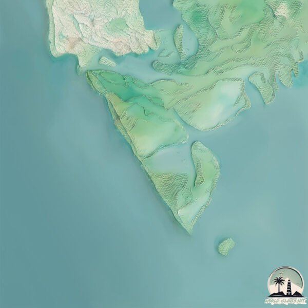
Welcome to Cape Romaro & Kice, a Tropical island in the Gulf of Mexico, part of the majestic Atlantic Ocean. This guide offers a comprehensive overview of what makes Cape Romaro & Kice unique – from its geography and climate to its population, infrastructure, and beyond. Dive into the details:
Geography and size of Cape Romaro & Kice
Size: 9.258 km²
Coastline: 30.7 km
Ocean: Atlantic Ocean
Sea: Gulf of Mexico
Continent: North America
Cape Romaro & Kice is a Small Island spanning 9.3 km² with a coastline of 30.7 km.
Archipel: –
Tectonic Plate: North America – Covers North America and parts of the Atlantic and Arctic Oceans, characterized by diverse geological features and varying levels of seismic activity.
The geographic heart of the island is pinpointed at these coordinates:
Latitude: 25.87205095 / Longitude: -81.68790181
Climate and weather of Cape Romaro & Kice
Climate Zone: Tropical
Climate Details: Tropical Savanna, Wet
Temperature: Hot
Climate Characteristics: Defined by distinct wet and dry seasons with high temperatures year-round. Pronounced rainfall occurs during the wet season, while the dry season is marked by drought.
Topography and nature of Cape Romaro & Kice
Timezone: UTC-05:00
Timezone places: America/New_York
Max. Elevation: 9 m
Mean Elevation: 5 m
Vegetation: Mangrove Forest
Tree Coverage: 86%
The mean elevation is 5 m. The highest elevation on the island reaches approximately 9 meters above sea level. The island is characterized by Plains: Flat, low-lying lands characterized by a maximum elevation of up to 200 meters. On islands, plains are typically coastal lowlands or central flat areas.
Dominating Vegetation: Mangrove Forest
Found in coastal areas and river deltas, these unique wetland ecosystems are adapted to saline conditions and are crucial for coastal protection and biodiversity. Cape Romaro & Kice has a tree cover of 86 %.
Vegetation: 3 vegetation zones – Moderately Diverse Island
These islands start to show a broader range of ecological niches. With three vegetation zones, they may offer a mix of ecosystems like coastal areas, inland woods, and perhaps a distinct wetland or dry area. This diversity supports a wider range of flora and fauna, making these islands more ecologically complex than those with minimal diversity.
Infrastructure and Travelling to Cape Romaro & Kice
Does the island have a public airport? no.
There is no public and scheduled airport on Cape Romaro & Kice. The nearest airport is Southwest Florida International Airport, located 71 km away.
Does the island have a major port? no.
There are no major ports on Cape Romaro & Kice. The closest major port is BOCA GRANDE, approximately 112 km away.
The mean population of Cape Romaro & Kice is 0 per km². Cape Romaro & Kice is Uninhabited. The island belongs to United States of America.
Continuing your journey, Sanibel is the next notable island, situated merely km away.
Exploring Cape Romano Shoals & Blind Pass's Natural Beauty!
We venture out to see if we can get to Cape Romano Shoals, having never been there and it is notoriously shallow water.Exploring Cape Romano Shoals & Blind Pass's Natural Beauty!
We venture out to see if we can get to Cape Romano Shoals, having ...
We venture out to see if we can get to Cape Romano Shoals, having never been there and it is notoriously shallow water.
The Dome Home of Cape Romano, Florida
During our Wednesday morning boat ride with Captain Dave, we visited ...
During our Wednesday morning boat ride with Captain Dave, we visited what's left of the famous Dome House at Cape Romano, ...
Cape Romano Camping Trip Christmas 2015
Cape Romano Camping Trip Christmas 2015.
Cape Romano Camping Trip Christmas 2015.
The Dome House of Cape Romano, FL
We visited the Cape Romano Dome House during our Wednesday morning ...
We visited the Cape Romano Dome House during our Wednesday morning boat ride with Captain Dave from Naples Bay ...
My 1st Trip to #Marco Shelling: #Tigertail, #Kice & Cape Romano Dome Home
The name, “Marco” sparks excitement in many shellers and it sure does ...
The name, “Marco” sparks excitement in many shellers and it sure does get me all excited! Come walk with me as I share my first ...
It's only a matter of time until the world-famous Cape Romano Dome House disappears
Cape Romano Shoals Kayak Camping - 4K
Camped Feb 5 - Feb 6 Launched kayak at Calusa Island Marina in ...
Camped Feb 5 - Feb 6 Launched kayak at Calusa Island Marina in Goodland, FL. Cost is $15.00 ramp fee plus $5 per night for car ...
Exclusive 4K HD Aerial Video of the Abandoned Cape Romano Dome House
Enjoy these captivating aerial views of the abandoned Cape Romano ...
Enjoy these captivating aerial views of the abandoned Cape Romano domes recorded on July 17, 2015 in stunning 4K Ultra HD ...
Haunting Mystique of the Abandoned Cape Romano Dome Homes
Delve into the eerie allure of Cape Romano Dome Homes, an ...
Delve into the eerie allure of Cape Romano Dome Homes, an architectural mystery off the coast of Florida. Discover their ...
Remembering the Legendary Cape Romano Dome House
The Cape Romano Dome House, along with the friendships we forged on ...
The Cape Romano Dome House, along with the friendships we forged on our Dome House boat tours, will always hold a special ...
BACKROOMS IN REAL IN GOOGLE EARTH CAPE ROMANA DOME HOUSE
Cape Romano abandoned beach dome houses in Southwest Florida
Location: 25.8453° N, 81.6811° W Not much is known about these ...
Location: 25.8453° N, 81.6811° W Not much is known about these mysterious dome houses that are abandoned.
some strange backrooms type of place with a parrot at cape Romano dome house
shout out to Capital Gains Angelina Garza The Pibby Cuphead for ...
shout out to Capital Gains Angelina Garza The Pibby Cuphead for finding this location ...
DoFloridaRight - Catching a snook at the Cape Romano Dome Home
On a recent trip to check out the Cape Romano Dome Home, we had to see ...
On a recent trip to check out the Cape Romano Dome Home, we had to see what fish were hiding up under the now submerged ...
Cape Romano Fishing Resort | Fishing Vacation Restaurant
Cape Romano Fishing Resort|Fishing Vacation Restaurant The I Love ...
Cape Romano Fishing Resort|Fishing Vacation Restaurant The I Love Florida Fishing Show as seen on ...
The remains of Cape Romano Done Houses in Marco Island Florida.
Originally built in 1981 the dome houses were abandoned in ...
Originally built in 1981 the dome houses were abandoned in deteriorating for years until finally destroyed by Hurricane Ian.
Cape Romano Dome House & The Everglades
Sailing to Cape Romano Dome House & The Everglades in Florida Check ...
Sailing to Cape Romano Dome House & The Everglades in Florida Check out our real-time daily updates on our blog: ...
The Destruction of the Cape Romano Dome House: Marco Island Florida #historicaltidbits
The Cape Romano Dome House was a unique and futuristic structure built ...
The Cape Romano Dome House was a unique and futuristic structure built in 1982 by retired oil producer Bob Lee on an islet ...
The Abandoned Dome House of Cape Romano
The abandoned dome house on Cape Romano south of Marco Island. It was ...
The abandoned dome house on Cape Romano south of Marco Island. It was 3rd on this list:
http://imgur.com/a/D9iDC The story ...
🏝️ Dive into the captivating world of Cape Romano Shell Natives
Dive into the captivating world of Cape Romano Shell Natives. You ...
Dive into the captivating world of Cape Romano Shell Natives. You won't believe their unique lifestyle and history! Swipe left to ...
Cape Romano/ Marco island Drone Video!!
This is an arial view of the beautiful Cape Romano island, out of ...
This is an arial view of the beautiful Cape Romano island, out of Marco Island Florida. Enjoy!!
A Narrated Tour of Cape Romano (Dome House), and the Ten Thousand Islands
Explore Florida's Ten Thousand Islands just off Marco Island and see ...
Explore Florida's Ten Thousand Islands just off Marco Island and see the unique Dome House located at the south end of Cape ...
kayaking to Abandoned Dome Homes in Cape Romano, Florida
Getting to the Abandoned Dome Homes in Cape Romano Florida was no ...
Getting to the Abandoned Dome Homes in Cape Romano Florida was no joke. The round-trip took 10 hours by kayak but it was ...
sangat normal di cape romano dome house backroms
United States of America is classified as Developed region: G7: Group of Seven – Major advanced economies, including Canada, France, Germany, Italy, Japan, the United Kingdom, and the United States. The level of income is High income: OECD.
News – Latest Updates and Headlines from Cape Romaro & Kice
Stay informed with the most recent news and important headlines from Cape Romaro & Kice. Here’s a roundup of the latest developments.
Loading...
Please note: The data used here has been primarily extracted from satellite readings. Deviations from exact values may occur, particularly regarding the height of elevations and population density. Land area and coastline measurements refer to average values at mean high tide.