Caracas del Este
Welcome to Caracas del Este, a Tropical island in the Caribbean Sea, part of the majestic Atlantic Ocean. This guide offers a comprehensive overview of what makes Caracas del Este unique – from its geography and climate to its population, infrastructure, and beyond. Dive into the details:
- Geography and Size: Explore the island’s size and location.
- Climate and Weather: Weather patterns and temperature.
- Topography and Nature: Uncover the natural wonders of the island.
- Infrastructure and Travelling: Insights on reaching, staying, and making the most of your visit.
- News and Headlines: Latest News.
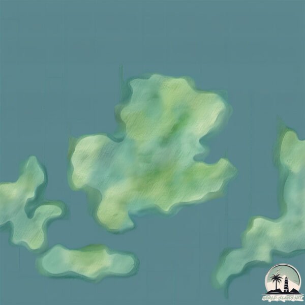
Geography and size of Caracas del Este
Size: 4.66 km²
Coastline: 11.5 km
Ocean: Atlantic Ocean
Sea: Caribbean Sea
Continent: South America
Caracas del Este is a Small Island spanning 4.7 km² with a coastline of 11.5 km.
Archipel: –
Tectonic Plate: Caribbean – Covering the Caribbean Sea and surrounding regions, this plate is bordered by the North American Plate and the South American Plate. Known for seismic activity, including earthquakes and volcanic eruptions, and features like the Puerto Rico Trench.
The geographic heart of the island is pinpointed at these coordinates:
Latitude: 10.36939892 / Longitude: -64.42420692
Climate and weather of Caracas del Este
Climate Zone: Tropical
Climate Details: Tropical Savanna, Wet
Temperature: Hot
Climate Characteristics: Defined by distinct wet and dry seasons with high temperatures year-round. Pronounced rainfall occurs during the wet season, while the dry season is marked by drought.
Topography and nature of Caracas del Este
Timezone: UTC-04:30
Timezone places: America/Caracas
Max. Elevation: 100 m
Mean Elevation: 72 m
Vegetation: Herbaceous Cover
Tree Coverage: 27%
The mean elevation is 72 m. The highest elevation on the island reaches approximately 100 meters above sea level. The island is characterized by Plains: Flat, low-lying lands characterized by a maximum elevation of up to 200 meters. On islands, plains are typically coastal lowlands or central flat areas.
Dominating Vegetation: Herbaceous Cover
Comprising mainly of grasses, herbs, and ferns, these areas are common in prairies, meadows, and savannas, and can vary widely in species composition. Caracas del Este has a tree cover of 27 %.
Vegetation: 5 vegetation zones – Highly Diverse Island
With five different vegetation zones, these islands offer a rich tapestry of ecosystems. The variety could include dense forests, open meadows, wetlands, coastal zones, and more. This level of diversity supports an intricate web of life, with each zone playing a vital role in the overall ecological health and balance of the island.
Infrastructure and Travelling to Caracas del Este
Does the island have a public airport? no.
There is no public and scheduled airport on Caracas del Este. The nearest airport is Cumaná (Antonio José de Sucre) Airport, located 32 km away.
Does the island have a major port? no.
There are no major ports on Caracas del Este. The closest major port is BAHIA DE PERTIGALETE, approximately 20 km away.
The mean population of Caracas del Este is 257 per km². Caracas del Este is Moderately Inhabited. The island belongs to Venezuela.
Continuing your journey, Cubagua is the next notable island, situated merely km away.
Año Inaugural del Parque del Este de Caracas. Película 8mm de 1961


Venezuela is classified as Emerging region: G20: Group of Twenty – Major economies comprising both developed and emerging countries, representing the world’s largest economies. The level of income is Upper middle income.
News – Latest Updates and Headlines from Caracas del Este
Stay informed with the most recent news and important headlines from Caracas del Este. Here’s a roundup of the latest developments.
Please note: The data used here has been primarily extracted from satellite readings. Deviations from exact values may occur, particularly regarding the height of elevations and population density. Land area and coastline measurements refer to average values at mean high tide.