Welcome to Catalina, a Polar island in the South Pacific Ocean, part of the majestic Pacific Ocean. This guide offers a comprehensive overview of what makes Catalina unique – from its geography and climate to its population, infrastructure, and beyond. Dive into the details:
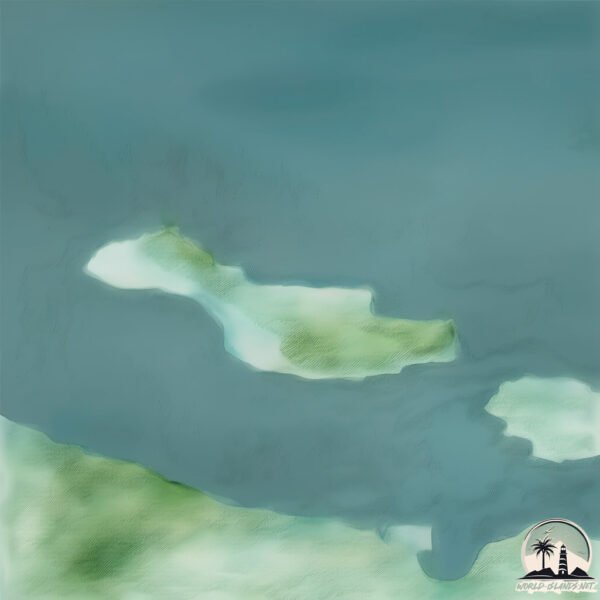
Geography and size of Catalina
Size: 1.879 km²
Coastline: 11.6 km
Ocean: Pacific Ocean
Sea: South Pacific Ocean
Continent: South America
Catalina is a Small Island spanning 1.9 km² with a coastline of 11.6 km.
Archipel: –
Tectonic Plate: Scotia – Situated in the Southern Ocean, surrounding the Scotia Sea, between South America and Antarctica, known for the Scotia Arc and active seismicity.
The geographic heart of the island is pinpointed at these coordinates:
Latitude: -54.80878785 / Longitude: -71.23178031
Climate and weather of Catalina
Climate Zone: Polar
Climate Details: Tundra
Temperature: Cold
Climate Characteristics: The tundra climate features long, extremely cold winters and short, cool summers. Vegetation is limited to mosses, lichens, and small shrubs due to the low temperatures and short growing seasons. Biodiversity is low, but some specialized species thrive.
Topography and nature of Catalina
Timezone: UTC-04:00
Timezone places: America/La_Paz
Max. Elevation: 114 m
Mean Elevation: 65 m
Vegetation: Herbaceous Cover
Tree Coverage: 46%
The mean elevation is 65 m. The highest elevation on the island reaches approximately 114 meters above sea level. The island is characterized by Plains: Flat, low-lying lands characterized by a maximum elevation of up to 200 meters. On islands, plains are typically coastal lowlands or central flat areas.
Dominating Vegetation: Herbaceous Cover
Comprising mainly of grasses, herbs, and ferns, these areas are common in prairies, meadows, and savannas, and can vary widely in species composition. Catalina has a tree cover of 46 %.
Vegetation: 5 vegetation zones – Highly Diverse Island
With five different vegetation zones, these islands offer a rich tapestry of ecosystems. The variety could include dense forests, open meadows, wetlands, coastal zones, and more. This level of diversity supports an intricate web of life, with each zone playing a vital role in the overall ecological health and balance of the island.
Infrastructure and Travelling to Catalina
Does the island have a public airport? no.
There is no public and scheduled airport on Catalina. The nearest airport is President Carlos Ibañez del Campo International Airport, located 204 km away.
Does the island have a major port? no.
There are no major ports on Catalina. The closest major port is PORT SAN JUAN DE LA JUAN, approximately 135 km away.
The mean population of Catalina is 0 per km². Catalina is Uninhabited. The island belongs to Chile.
Continuing your journey, Stewart is the next notable island, situated merely km away.
You can visit Santa Catalina Island for 1 day and see a lot! #california #catalinaisland California
You can visit Santa Catalina Island for 1 day and see a lot! #california #catalinaisland California
The best Catalina Island day trip itinerary ☀️
Who's looking for a full day trip to Catalina Island? Fill your day ...
Who's looking for a full day trip to Catalina Island? Fill your day with sightseeing on a golf cart or jet skiing around Avalon!
24 Hour Catalina Island Getaway
24 hour Catalina Island getaway - full itinerary on Instagram!
24 hour Catalina Island getaway - full itinerary on Instagram!
SHARKS IN CATALINA ISLAND #shark #sharks #la #losangeles #catalinaisland #history
CATALINA ISLAND Travel Guide – Plan the Perfect CALIFORNIA Getaway
Discover the Top 10 Things to Do in Catalina Island, California, from ...
Discover the Top 10 Things to Do in Catalina Island, California, from underwater adventures and zipline thrills to scenic hikes and ...
Catalina Island Day Trip: What to do in Avalon in One Day
Catalina Island is a beautiful location off the coast of Southern ...
Catalina Island is a beautiful location off the coast of Southern California. Avalon is the main city there and boats run from Long ...
CATALINA 🏝️ Is it worth it?
Catalina 🏝️ Is it worth it? Catalina is part of the Channel islands ...
Catalina 🏝️ Is it worth it? Catalina is part of the Channel islands archipelago. This video will answer if Catalina is worth it.
How much we spent to go to Catalina Island from LA? #catalinaisland #losangeles #thingstodo #shorts
Exclusive Tour of Catalina Island - The Avalon Casino, Chimes Tower, and Wrigley Memorial
If you enjoyed this video, please consider joining my Patreon to help ...
If you enjoyed this video, please consider joining my Patreon to help create more videos like this!
Catalina Island Tour!
Catalina Island Tour! #visitcatalinaisland #catalinaexpress ...
Catalina Island Tour! #visitcatalinaisland #catalinaexpress #catalinaisland #islandtour #island.
Island Life Near Los Angeles - What It's Really Like 🇺🇸
Just 22 miles off the coast of America's second-largest metro area ...
Just 22 miles off the coast of America's second-largest metro area lies a beautiful island with old-world charm, roaming bison, and ...
How does this place exist in the US?? 🤯 #travel #bucketlist #losangeles #catalina
How does this place exist in the US?? - Honestly THIS is the best ...
How does this place exist in the US?? - Honestly THIS is the best bucket list itinerary for Los Angeles I would do if I only had 24 ...
Cost of a week on Catalina Island will surprise you 🏝
CATALINA ISLAND: What to See, Do & Eat in Avalon
Today, we are heading 22 miles off the coast of Los Angeles to the ...
Today, we are heading 22 miles off the coast of Los Angeles to the beautiful Catalina Island. In this video, I'm taking you on a ...
Lost Spanish Treasure Worth A Billion Dollars - Catalina Island
If you enjoyed this video, please consider joining my Patreon to help ...
If you enjoyed this video, please consider joining my Patreon to help create more videos like this!
Things to Do On Catalina Island [THAT NO ONE ELSE IS TALKING ABOUT]
Just released, our new Travel Planner + Organizer ebook - check it out ...
Just released, our new Travel Planner + Organizer ebook - check it out today at
https://bit.ly/3e9wqoJ Today we're covering things ...
How would you spend 24 hours in Catalina island? #california #island #vacation #beach #food #travel
15 things to do on Catalina Island
15 things to do on Catalina Island 🏝️ Full article at ...
15 things to do on Catalina Island 🏝️ Full article at LoveTravelBeauty.com . . #catalinaisland #catalina #u #cat #california ...
HOW TO SPEND THE PERFECT DAY ON CATALINA ISLAND
48 Hours on California’s ISLAND PARADISE! - This Is Catalina Island
ad Catalina island is totally worth a visit! Just a quick ferry ride ...
ad Catalina island is totally worth a visit! Just a quick ferry ride from Los Angeles takes you to this little island paradise with so ...
10 Things I Wish I Knew BEFORE Going to Catalina Island California
Here are the 10 Things I Wish I Knew BEFORE Going to Catalina Island ...
Here are the 10 Things I Wish I Knew BEFORE Going to Catalina Island California! In this video I talk about everything regarding ...
7 THINGS TO KNOW BEFORE A TRIP TO CATALINA ISLAND! 🌴
Before you go on a trip to Catalina Island, California - there are 7 ...
Before you go on a trip to Catalina Island, California - there are 7 things you really need to know and be familiar with about the ...
The History of Catalina Island
Planning a trip to Catalina Island? Book your stay with Orbitz: ...
Planning a trip to Catalina Island? Book your stay with Orbitz:
https://bit.ly/2OQhS0i In this segment from our episode on Catalina ...
Catalina Island, California #travel #beautifulnature #nature
hiking on Catalina Island!
hermit gulch trail on catalina island covers 3.3 miles and 1177ft of ...
hermit gulch trail on catalina island covers 3.3 miles and 1177ft of elevation gain. this was the perfect activity for my short visit to ...
Chile is classified as Emerging region: G20: Group of Twenty – Major economies comprising both developed and emerging countries, representing the world’s largest economies. The level of income is Upper middle income.
News – Latest Updates and Headlines from Catalina
Stay informed with the most recent news and important headlines from Catalina. Here’s a roundup of the latest developments.
Loading...
Please note: The data used here has been primarily extracted from satellite readings. Deviations from exact values may occur, particularly regarding the height of elevations and population density. Land area and coastline measurements refer to average values at mean high tide.


![Things to Do On Catalina Island [THAT NO ONE ELSE IS TALKING ABOUT]](https://i.ytimg.com/vi/WZ97O6Rec2k/mqdefault.jpg)