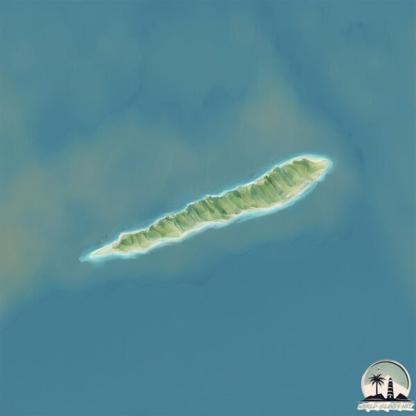
Cayman Brac Island
Welcome to Cayman Brac Island, a Tropical island in the Caribbean Sea, part of the majestic Atlantic Ocean. This guide offers a comprehensive overview of what makes Cayman Brac Island unique – from its geography and climate to its population, infrastructure, and beyond. Dive into the details:
- Geography and Size: Explore the island’s size and location.
- Climate and Weather: Weather patterns and temperature.
- Topography and Nature: Uncover the natural wonders of the island.
- Infrastructure and Travelling: Insights on reaching, staying, and making the most of your visit.
- News and Headlines: Latest News.
Geography and size of Cayman Brac Island
Size: 39.3 km²
Coastline: 43.3 km
Ocean: Atlantic Ocean
Sea: Caribbean Sea
Continent: North America
Cayman Brac Island is a Medium Island spanning 39 km² with a coastline of 43 km.
Archipel: Greater Antilles – A major island group in the Caribbean, including Cuba, Jamaica, Hispaniola, and Puerto Rico, known for their rich history and diverse cultures.
Tectonic Plate: Africa – One of the world’s largest tectonic plates, covering the African continent and parts of the surrounding oceans, known for its stability with some active rift zones.
The geographic heart of the island is pinpointed at these coordinates:
Latitude: 19.72084787 / Longitude: -79.79742899
Climate and weather of Cayman Brac Island
Climate Zone: Tropical
Climate Details: Tropical Savanna, Wet
Temperature: Hot
Climate Characteristics: Defined by distinct wet and dry seasons with high temperatures year-round. Pronounced rainfall occurs during the wet season, while the dry season is marked by drought.
Topography and nature of Cayman Brac Island
Timezone: UTC-05:00
Timezone places: America/New_York
Max. Elevation: 44 m
Mean Elevation: 21 m
Vegetation: Evergreen Broadleaf Forest
Tree Coverage: 33%
The mean elevation is 21 m. The highest elevation on the island reaches approximately 44 meters above sea level. The island is characterized by Plains: Flat, low-lying lands characterized by a maximum elevation of up to 200 meters. On islands, plains are typically coastal lowlands or central flat areas.
Dominating Vegetation: Evergreen Broadleaf Forest
Characterized by dense, lush canopies of broadleaf trees that retain their leaves year-round. These forests are typically found in tropical and subtropical regions and are known for their high biodiversity. Cayman Brac Island has a tree cover of 33 %.
Vegetation: 12 vegetation zones – Exceptionally Diverse Island
Islands with more than ten vegetation zones are among the most ecologically rich and varied in the world. These islands are akin to miniature continents, boasting an incredible array of ecosystems. The sheer range of habitats, from high peaks to deep valleys, rainforests to deserts, creates a mosaic of life that is unparalleled. They are crucial for conservation and ecological studies.
Infrastructure and Travelling to Cayman Brac Island
Does the island have a public airport? yes.
Cayman Brac Island has a public and scheduled airport. The following airports are located on this island: Charles Kirkconnell International Airport.
Does the island have a major port? yes.
Cayman Brac Island is home to a major port. The following ports are situated on the island: CAYMAN BRAC.
The mean population of Cayman Brac Island is 36 per km². Cayman Brac Island is Gently Populated. The island belongs to United Kingdom.
Continuing your journey, Little Cayman is the next notable island, situated merely km away.
Cayman Brac is The Island You Should Actually Visit in the Cayman Islands


United Kingdom is classified as Developed region: G7: Group of Seven – Major advanced economies, including Canada, France, Germany, Italy, Japan, the United Kingdom, and the United States. The level of income is High income: OECD.
News – Latest Updates and Headlines from Cayman Brac Island
Stay informed with the most recent news and important headlines from Cayman Brac Island. Here’s a roundup of the latest developments.
- Fact Check: Watch out for claim Thomas Massie exposed Stephen Miller funneling $890M through Cayman Islands - Yahoo News Canadaon 4 April 2026
Fact Check: Watch out for claim Thomas Massie exposed Stephen Miller funneling $890M through Cayman Islands Yahoo News Canada
- Easter camping in the Cayman Islands - Cayman Compasson 3 April 2026
Easter camping in the Cayman Islands Cayman Compass
- Appleby Cayman Islands appoints new managing partner - Cayman Compasson 2 April 2026
Appleby Cayman Islands appoints new managing partner Cayman Compass
- Cayman Islands recognised as key international reinsurance jurisdiction: SOA - Reinsurance Newson 27 March 2026
Cayman Islands recognised as key international reinsurance jurisdiction: SOA Reinsurance News
- Priestleys adds to its growing Cayman Islands legal team - Cayman Compasson 23 March 2026
Priestleys adds to its growing Cayman Islands legal team Cayman Compass
- Cayman’s first national park named on the Brac - Cayman Compasson 23 March 2026
Cayman’s first national park named on the Brac Cayman Compass
- Jawara Alleyne’s guide to the Cayman Islands - Financial Timeson 13 March 2026
Jawara Alleyne’s guide to the Cayman Islands Financial Times
- Cayman Islands - British Overseas Territory, Tax Haven, Caribbean - Britannicaon 12 March 2026
Cayman Islands - British Overseas Territory, Tax Haven, Caribbean Britannica
- Government targets 2027 for Cayman Islands AI legislation - Cayman Compasson 10 March 2026
Government targets 2027 for Cayman Islands AI legislation Cayman Compass
- Learning opportunities in the Cayman Islands - Cayman Compasson 4 March 2026
Learning opportunities in the Cayman Islands Cayman Compass
Please note: The data used here has been primarily extracted from satellite readings. Deviations from exact values may occur, particularly regarding the height of elevations and population density. Land area and coastline measurements refer to average values at mean high tide.